海拔
维基百科,自由的百科全书
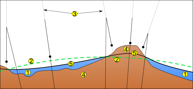
海拔(英语:altitude),对应英语术语还可翻译为高度或深度,这个术语的定义基于了所用语境(航空,几何,地理考察,体育,大气压力,等等)。作为一般性定义,高度就是一个点或物体与一个参考基准面之间通常在垂直或“向上”方向的距离测量。在“向下”方向的垂直距离测量一般称为深度。这个参考基准面通常是根据语境而变化的。这个术语最常用于一个位置距离海平面的高度,通常以平均海平面做标准来计算为平均海拔;在地理学中,更偏好对此使用术语相对高度(英语:elevation)。
各地水平原点
备注
![]() |
维基共享资源中相关的多媒体资源:海拔 |
参见
外部链接
- Altitude pressure calculator. Apex (altitude physiology expeditions). [2006-08-08]. (原始内容存档于2017-08-03).
- The Race to the Stratosphere. U.S. Centennial of Flight Commission. [25 January 2006]. (原始内容存档于2006年3月9日).
- Downloadable ETOPO2 Raw Data Database (2 minute grid) Archive.is的存档,存档日期2012-12-14
- Downloadable ETOPO5 Raw Data Database (5 minute grid) Archive.is的存档,存档日期2012-12-14
- Calculate true altitude with these JavaScript applications 页面存档备份,存于互联网档案馆
- Find the altitude of any place 页面存档备份,存于互联网档案馆
Text is available under the CC BY-SA 4.0 license; additional terms may apply.
Images, videos and audio are available under their respective licenses.
Cover photo is available under {{::mainImage.info.license.name || 'Unknown'}} license.
Credit:
(see original file).