File:Mazama_bathymetry_survey_map.jpg
维基百科,自由的 encyclopedia
此为最大尺寸。
Mazama_bathymetry_survey_map.jpg (600 × 345像素,文件大小:61 KB,MIME类型:image/jpeg)
| 描述Mazama bathymetry survey map.jpg |
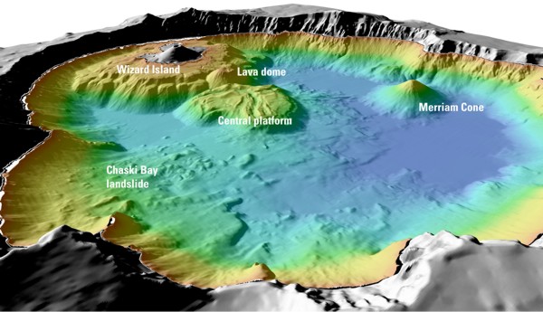
English: "Details of features beneath the surface of Crater Lake constructed using data from the 2000 bathymetry survey. Colors range from orange to blue with increasing water depth." |
| 来源 | "Mount Mazama and Crater Lake: Growth and Destruction of a Cascade Volcano" |
| 作者 | U.S. Geological Survey |
许可协议
| Public domainPublic domainfalsefalse |
|
Bahasa Indonesia ∙ català ∙ čeština ∙ Deutsch ∙ eesti ∙ English ∙ español ∙ français ∙ galego ∙ italiano ∙ Nederlands ∙ português ∙ polski ∙ sicilianu ∙ suomi ∙ Tiếng Việt ∙ Türkçe ∙ български ∙ македонски ∙ русский ∙ മലയാളം ∙ 한국어 ∙ 日本語 ∙ 中文 ∙ 中文(简体) ∙ 中文(繁體) ∙ العربية ∙ فارسی ∙ +/− |
原始上传日志
The original description page was here. All following user names refer to en.wikipedia.
- 2004-05-18 06:41 Mav 600×345× (62232 bytes) [[USGS]] image from [http://geopubs.wr.usgs.gov/fact-sheet/fs092-02/] <br><br>{{msg:PD}}
文件历史
点击某个日期/时间查看对应时刻的文件。
| 日期/时间 | 缩略图 | 大小 | 用户 | 备注 | |
|---|---|---|---|---|---|
| 当前 | 2009年7月13日 (一) 06:26 | | 600 × 345(61 KB) | ZabMilenko | {{Information |Description={{en|en:USGS image from [http://geopubs.wr.usgs.gov/fact-sheet/fs092-02/] en:Category:Images of Oregon}} |Source=Transferred from [http://en.wikipedia.org en.wikipedia]; transferred to Commons by [[User:ZabMilenko |
文件用途
以下页面使用本文件:
全域文件用途
以下其他wiki使用此文件:
- bh.wikipedia.org上的用途
- el.wikipedia.org上的用途
- en.wikipedia.org上的用途
- eo.wikipedia.org上的用途
- es.wikipedia.org上的用途
- fa.wikipedia.org上的用途
- it.wikipedia.org上的用途
- ja.wikipedia.org上的用途
- lv.wikipedia.org上的用途
- ms.wikipedia.org上的用途
- simple.wikipedia.org上的用途
- sl.wikipedia.org上的用途
- ur.wikipedia.org上的用途
- vi.wikipedia.org上的用途
- www.wikidata.org上的用途
元数据
此文件中包含有扩展的信息。这些信息可能是由数码相机或扫描仪在创建或数字化过程中所添加。
如果此文件的源文件已经被修改,一些信息在修改后的文件中将不能完全反映出来。
| _error | 0 |
|---|