File:Rajendra_territories_cl.png
维基百科,自由的 encyclopedia
Rajendra_territories_cl.png (650 × 464像素,文件大小:504 KB,MIME类型:image/png)
The factual accuracy of 此地图 or the file name is disputed.
Reason: No source for the actual historical boundaries. However discussion has been made in https://en.wikipedia.org/wiki/Talk:Chola_dynasty#Maps |  |
摘要
| 描述Rajendra territories cl.png |
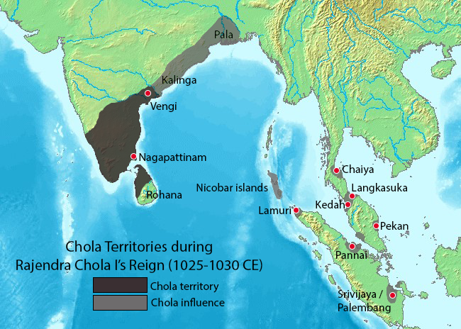
Map showing the extent of the Chola empire during Rajendra Chola I. Source of map: http://www2.demis.nl/mapserver/mapper.asp (mention : "Disclaimer: With this statement DEMIS BV grants you permission to freely copy the PNG images returned by our server and use them for your own purposes, including web pages. We would appreciate a reference to our server but such a reference is not required, nor do we take responsibility for the accuracy or quality of the maps". at http://www2.demis.nl/mapserver/DataSrc.htm) Modified by myself using Adobe Photoshop. Note: This file was imported to Commons by Nicke L on 25 June 2006, then updated based on https://commons.wikimedia.org/wiki/File:Rajendra_map_new.svg and https://en.wikipedia.org/wiki/Talk:Chola_dynasty#Maps by Verosaurus on 27 December 2022. Pegu isn't included in the influence area since the original map did not include that city. |
||||||||
| 来源 | Source of map: http://www2.demis.nl/mapserver/mapper.asp | ||||||||
| 作者 | User Venu62 on en.wikipedia | ||||||||
| 授权 (二次使用本文件) |
|
||||||||
| 其他版本 |
Originally from en.wikipedia; description page is (was) here
|

说明
此文件中描述的项目
描绘内容
GNU自由文档许可证1.2或更高版本 简体中文(已转写)
知识共享署名-相同方式共享3.0未本地化版本 简体中文(已转写)
文件历史
点击某个日期/时间查看对应时刻的文件。
| 日期/时间 | 缩略图 | 大小 | 用户 | 备注 | |
|---|---|---|---|---|---|
| 当前 | 2022年12月27日 (二) 21:44 | | 650 × 464(504 KB) | Verosaurus | Revised based on https://commons.wikimedia.org/wiki/File:Rajendra_map_new.svg and https://en.wikipedia.org/wiki/Talk:Chola_dynasty#Maps . Pegu isn't included since it's not on the original map, furthermore, it isn't mentioned in the Tanjore inscription. |
| 2006年6月25日 (日) 13:40 |  | 482 × 430(119 KB) | Nicke L | {{Information| |Description= == Summary == Map showing the extent of the Chola empire during Rajendra Chola I. Source of map: http://www2.demis.nl/mapserver/mapper.asp (mention : "Disclaimer: With this statement DEMIS BV grants you permission to freely c |
文件用途
以下页面使用本文件:
全域文件用途
以下其他wiki使用此文件:
- ast.wikipedia.org上的用途
- en.wikipedia.org上的用途
- es.wikipedia.org上的用途
- fr.wikipedia.org上的用途
- ko.wikipedia.org上的用途
- lt.wikipedia.org上的用途
- nl.wikipedia.org上的用途
- sq.wikipedia.org上的用途
- sv.wikipedia.org上的用途
- ta.wikipedia.org上的用途
- zh-yue.wikipedia.org上的用途
元数据
此文件中包含有扩展的信息。这些信息可能是由数码相机或扫描仪在创建或数字化过程中所添加。
如果此文件的源文件已经被修改,一些信息在修改后的文件中将不能完全反映出来。
| 水平分辨率 | 37.8 dpc |
|---|---|
| 垂直分辨率 | 37.8 dpc |