File:Thermohaline_Circulation_2.png
维基百科,自由的 encyclopedia
本预览的尺寸:800 × 502像素。 其他分辨率:320 × 201像素 | 640 × 401像素 | 1,100 × 690像素。
原始文件 (1,100 × 690像素,文件大小:122 KB,MIME类型:image/png)
摘要
| 描述Thermohaline Circulation 2.png |
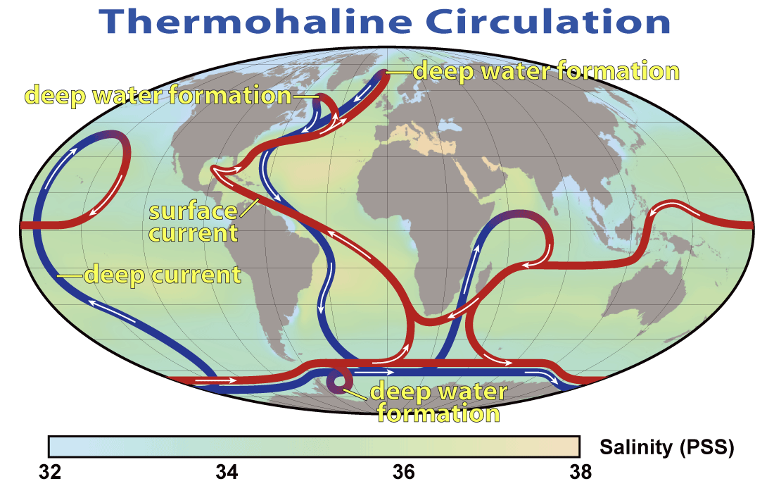
English: This map shows the pattern of thermohaline circulation also known as "meridional overturning circulation". This collection of currents is responsible for the large-scale exchange of water masses in the ocean, including providing oxygen to the deep ocean. The entire circulation pattern takes ~2000 years.
Deutsch: Thermohaline Zirkulation und die Entstehung von kaltem, dichtem Tiefenwasser im Nordmeer |
||||||
| 日期 | |||||||
| 来源 | NASA Earth Observatory | ||||||
| 作者 | Robert Simmon, NASA. Minor modifications by Robert A. Rohde also released to the public domain | ||||||
| 授权 (二次使用本文件) |
|
||||||
| 其他版本 |
 |


|
此meteorology图片可使用矢量图形重新创建为SVG文件。这具有很多好处;更多信息请参见共享资源:待清理媒体。如果存在此图片的SVG格式,请将其上传,然后将此模板替换为
{{vector version available|新图片名称}}。
建议您将SVG命名为“Thermohaline Circulation 2.svg”,这样在使用Vector version available(或Vva)模板时就不需要填写新图片名称参数。 |
说明
添加一行文字以描述该文件所表现的内容
此文件中描述的项目
描绘内容
29 3 2008
文件历史
点击某个日期/时间查看对应时刻的文件。
| 日期/时间 | 缩略图 | 大小 | 用户 | 备注 | |
|---|---|---|---|---|---|
| 当前 | 2008年3月29日 (六) 20:08 | | 1,100 × 690(122 KB) | Dragons flight | {{Information |Description=This map shows the pattern of w:thermohaline circulation also known as "meridional overturning circulation". This collection of currents is responsible for the large-scale exchange of water masses in the ocean, including p |
文件用途
以下4个页面使用本文件:
全域文件用途
以下其他wiki使用此文件:
- ar.wikipedia.org上的用途
- ast.wikipedia.org上的用途
- az.wikipedia.org上的用途
- ba.wikipedia.org上的用途
- bcl.wikipedia.org上的用途
- be.wikipedia.org上的用途
- bg.wikipedia.org上的用途
- bh.wikipedia.org上的用途
- bn.wikipedia.org上的用途
- bs.wikipedia.org上的用途
- bxr.wikipedia.org上的用途
- ca.wikipedia.org上的用途
- cdo.wikipedia.org上的用途
- cs.wikipedia.org上的用途
- da.wikipedia.org上的用途
- da.wikibooks.org上的用途
- de.wikipedia.org上的用途
- el.wikipedia.org上的用途
- en.wikipedia.org上的用途
- en.wikibooks.org上的用途
查看本文件的更多全域用途。