File:East-Hem_400ad.jpg
維基百科,自由的 encyclopedia
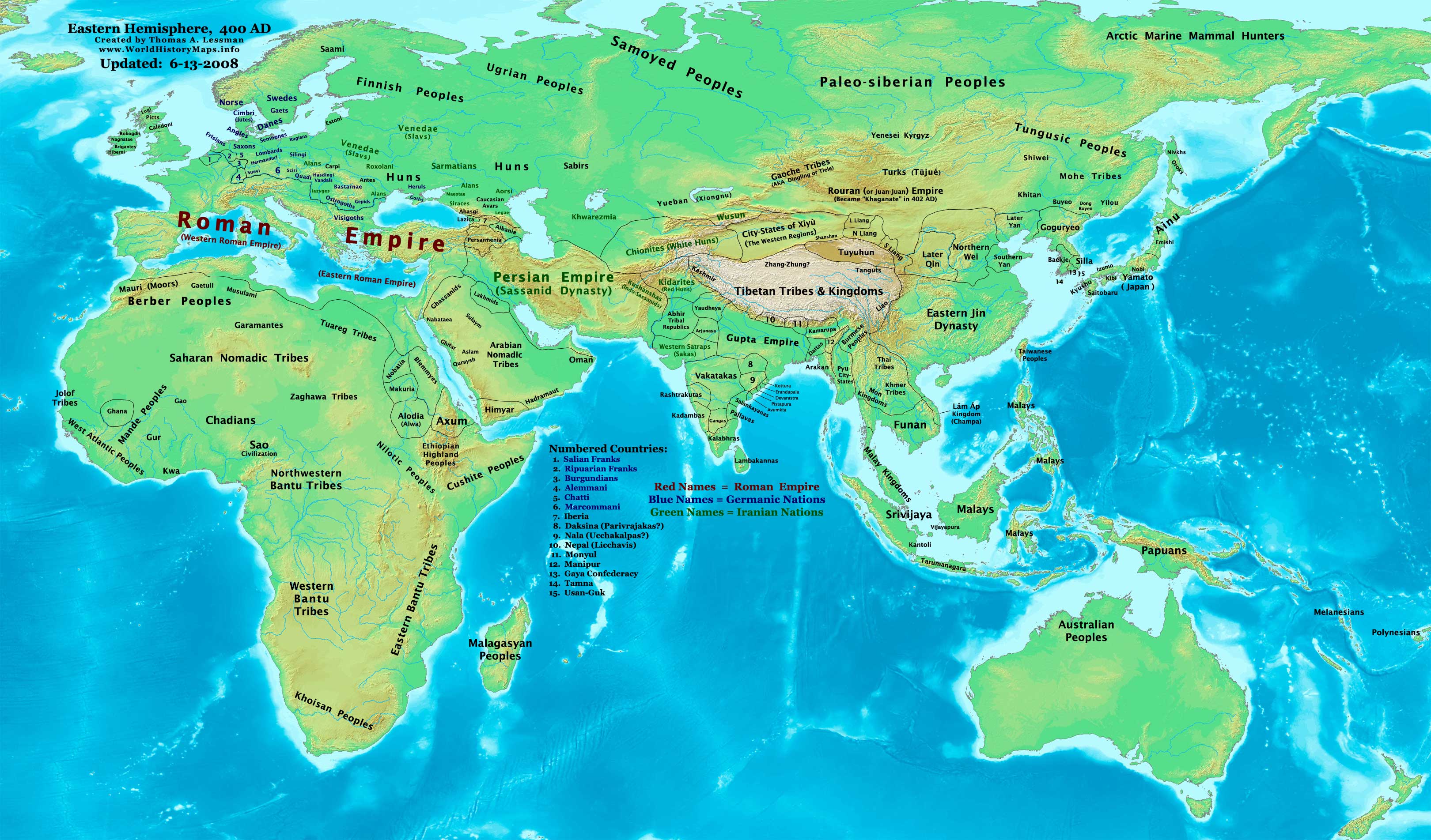
原始檔案 (3,240 × 1,903 像素,檔案大小:749 KB,MIME 類型:image/jpeg)

|
本圖片是以PNG、GIF或JPEG格式上傳。然而,其中包含的資料或訊息,應該重新建立成可縮放向量圖形(SVG)檔案,以更有效率或更準確的方式儲存。如有可能,請上傳本圖片的SVG格式版本。在上傳之後,請修改維基各姊妹計畫中所有使用舊版圖片的條目(列在圖像連結章節中),替換為新版圖片,並在舊圖片的描述頁中加入{{Vector version available|新圖片名稱.svg}}模板,同時移除本模板。
|
 | 這個file中的所有圖片名上傳在JPEG格式,即使它包含非照片數據。該信息可以以PNG或SVG格式更有效或更準確地存儲。 如果可能,請上傳此圖像的PNG或SVG版本,不含壓縮失真,源自非JPEG源(或移除現存的失真)。完成後,請使用{{Superseded|NewImage.ext}}標記JPEG版本並刪除此標記。此標籤不應應用於照片或掃描件。如需更多信息,請參閱{{BadJPEG}}。 |  |
| 描述East-Hem 400ad.jpg |
English: Eastern Hemisphere in 400 AD |
|||
| 來源 | self-made (For reference information, see the Map Source References section below.) | |||
| 作者 | Thomas Lessman (Contact!) | |||
| 授權許可 (重用此檔案) |
我,本作品的著作權持有者,決定用以下授權條款發佈本作品: 此檔案採用創用CC 姓名標示-相同方式分享 3.0 未在地化版本授權條款。
|
|||
| 其他版本 |
|
.jpg)
Map Summary
Original Source URL: http://www.thomaslessman.com/History/images/East-Hem_400ad.jpg.
This map of the Eastern Hemisphere in 400 AD was created by Thomas Lessman, based on information from the sources listed below. This map is free for educational use (see Permission info above). When using this map, please mention that it is available for free at www.WorldHistoryMaps.info.
Map Source References
- Remember, sources often conflict with each other. This map is only as accurate as the information that is available to me. To report any errors or to help further this work, please click here, or email Thomas Lessman at talessman@yis.us
Source References for information contained in this map:
Primary Sources for East-Hem_400ad.jpg:
- 1. The DK Atlas of World History, 2000 Edition (See specific references below).
- 2. WorldHistoryMaps.com's maps of the Countries of the World, 1-1-386 archive copy at the Wayback Machine.
- 3. Wikimedia's World Map 400 CE, made by User:Javierfv1212, and Wikipedia articles (noted below).
I - African Information
Note: Most of the African Information I have for 400 AD comes from The DK Atlas of World History map of The Development of Complex Societies in Africa; (Pg 160).
- (Bantus, Berber Tribes, Chadians, Cushites, Daamat, Garamantes, Gur, Khoisan Peoples, Kwa, Libyans, Mandes, Nilotic Peoples, West Atlantic Peoples)
II - Asian Information is derived from these sources:
- Arabian Tribal Locations are derived from this map of 5th century Arabia, from www.MidEastWeb.org.
- Caucasian borders are from the map of Europe in 400 AD on Euratlas.com.
- (Albania, Iberia, Lazica, and Persarmenia, etc.)
- China's Eastern Jin Dynasty borders are derived from:
- 1. The DK Atlas of World History map of The Later 16 Kingdoms period, c. 400 CE, (Pg 261)
- 2. The WorldHistoryMaps.com map of the Countries of the World, 1-1-386 archive copy at the Wayback Machine.
- Funan borders are derived from:
- 1. The DK Atlas of World History, 2000 Edition; map of The World in 250 CE, (Pg 46-47).
- 2. Wikipedia's article about Funan, along with this map of Funan in 001, uploaded by User:L_joo.
- Indian Information is derived from:
- 1. Comparison of WorldHistoryMaps.com's maps of the Countries of the World in 386 archive copy at the Wayback Machine and 420 CE. (Note: The 386 map is available for free on their sample page. The 420 CE map is available only to paid accounts.)
- 2. This map of Gupta Expansion[失效連結], from "The World: Grand Atlas of History" by SA Ebisa, put online by the Imperial Maps archive copy at the Wayback Machine website (in Spanish).
- 3. Any information missing from the maps listed above is covered in Wikipedia articles on the countries depicted.
- Japanese information is derived from the DK Atlas of World History, 2000 Edition; map of State Formation in Korea & Japan to 650 CE; (Pg 264)
- Kidarite and Kushansha borders are derived from the WorldHistoryMaps.com map of the Countries of the World in 386 CE archive copy at the Wayback Machine. (Note: These maps show Kidarites as Kingdom of Gandhara and Taxila.)
- Korean and Manchurian information comes from this map of the History_of_Korea-375.png, created by User:Historiographer.
- Malay Kingdoms and peoples are derived from The DK Atlas of World History, 2000 Edition; map of "Areas influenced by India in SE Asia to 650 CE"; (Pg 241)
- Rouran or Juan-Juan information is from the History & Commercial Atlas of China, map of Asia in 440 AD, available on Huhai.net, along with Wikipedia's article about the Rouran and its first two Khagans.
- Sassanid Persian Empire borders are derived from:
- 1. Eastern Sassanid borders are based on the WorldHistoryMaps.com map of the Countries of the World in 386 CE archive copy at the Wayback Machine.
- 2. Western Sassanid borders are based on the Euratlas.com map of Europe in 400 AD.
- Turks, Yueban, & Gaoche locations come from:
- 1. The History & Commercial Atlas of China, map of Asia in 440 AD, available on Huhai.net.
- 2. Wikipedia's articles about the Yueban state, the Dingling (aka Gaoche), and the Göktürks.
III - European Information is mostly derived from the Euratlas.com map of Europe in 400 AD.
IV - Australia, Siberia, & Other Fringe Information is derived from:
- 1. Wikimedia's map of the World Map 400 CE, made by User:Javierfv1212.
- 2. Comparison of The DK Atlas of World History maps of The World in 250 CE (Pg 47) and The World in 500 CE (Pg 51).
Note: Much of the information in this map was cross-checked with Bruce Gordon's Regnal Chronologies
Other Maps by Thomas Lessman
| Maps of the eastern hemisphere showing history
Bold dates are available on Wikimedia or Wikipedia. | ||
| Primeval | ||
| Ancient
|
·| 600 BC | 550 BC | 527 BC | 500 BC |
400 BC | ·| 1 AD | 50 AD | 100 AD | 200 AD | 300 AD | | |
| Medieval |
·| 500 AD | 565 AD | 600 AD | 700 AD | | |
| Modern |
·| 1500 AD | · * For historical maps of the whole world, | |
| history links talk edit view | ||
原始上傳日誌
- 2008-02-01 23:57 Talessman 3240×1903×8 (738603 bytes) Corrected borders of North China, southeast Asia, India, added more info for Siberia and Africa.
- 2007-12-25 01:31 Talessman 3240×1903×8 (729008 bytes) Corrected borders in central Asia and India, more info for Korea, etc.
- 2007-11-21 21:34 Talessman 3240×1903×8 (718510 bytes) Reverted to version as of 01:11, 19 November 2007 (Somehow I uploaded wrong version...)
- 2007-11-21 21:34 Talessman 3240×1903×8 (718510 bytes) Reverted to version as of 01:11, 19 November 2007 (Somehow I uploaded wrong version...)
- 2007-11-19 18:53 Talessman 3240×1903×8 (718510 bytes) Corrected minor spelling errors, added info for areas that were missing from previous version.
- 2007-11-19 01:11 Talessman 3240×1903×8 (718510 bytes) Updated information on fringe peoples, fixed Jin/Pyu/Tibetan borders, fixed Makuria/Nobatia/Alodia/Blemmyes borders, fixed Arabian borders, added Nepal.
- 2007-10-30 00:11 Talessman 3240×1903×8 (695017 bytes) Added updated info for Far Eastern regions
- 2007-10-01 22:17 Talessman 2880×1692×8 (550413 bytes) Author: Thomas A. Lessman. Source URL: http://www.ThomasLessman.com/History/images/East-Hem_400ad.jpg. Image was created by me (Thomas Lessman) based on historical information located on Wikipedia, as well as information from maps located in Wikipedia and
- 2007-09-12 21:47 Talessman 2880×1692×8 (533817 bytes) Author: Thomas A. Lessman. Source URL: http://www.ThomasLessman.com/History/images/East-Hem_400ad.jpg. Image was created by me (Thomas Lessman) based on historical information located on Wikipedia, as well as information from maps located in Wikipedia and
| 註解 InfoField | 該圖片含有註解:在維基媒體共享資源上查看註解 |
Western Roman Empire
Byzantine Empire
說明
在此檔案描寫的項目
描繪內容
檔案歷史
點選日期/時間以檢視該時間的檔案版本。
| 日期/時間 | 縮圖 | 尺寸 | 使用者 | 備註 | |
|---|---|---|---|---|---|
| 目前 | 2008年6月14日 (六) 00:02 | | 3,240 × 1,903(749 KB) | Talessman | {{Information |Description= |Source= |Date= |Author= |Permission= |other_versions= }} |
| 2008年6月14日 (六) 00:00 |  | 3,240 × 1,903(749 KB) | Talessman | ||
| 2008年5月9日 (五) 17:07 |  | 3,240 × 1,903(740 KB) | Talessman | {{Information |Description=Eastern Hemisphere in 400 AD. |Source=self-made |Author=User:Talessman |Permission={{self|cc-by-sa-3.0}} }} |
檔案用途
沒有使用此檔案的頁面。
全域檔案使用狀況
以下其他 wiki 使用了這個檔案:
- arz.wikipedia.org 的使用狀況
- be.wikipedia.org 的使用狀況
- bs.wikipedia.org 的使用狀況
- da.wikipedia.org 的使用狀況
- en.wikipedia.org 的使用狀況
- es.wikipedia.org 的使用狀況
- fi.wikipedia.org 的使用狀況
- frr.wikipedia.org 的使用狀況
- gl.wikipedia.org 的使用狀況
- hu.wikipedia.org 的使用狀況
- ko.wikipedia.org 的使用狀況
- lt.wikipedia.org 的使用狀況
- mk.wikipedia.org 的使用狀況
- my.wikipedia.org 的使用狀況
- pl.wikipedia.org 的使用狀況
- rue.wikipedia.org 的使用狀況
- ru.wikipedia.org 的使用狀況
- shn.wikipedia.org 的使用狀況
- sh.wikipedia.org 的使用狀況
- sv.wikipedia.org 的使用狀況
- sw.wikipedia.org 的使用狀況
- ta.wikipedia.org 的使用狀況
- tl.wikipedia.org 的使用狀況
- vi.wikipedia.org 的使用狀況
詮釋資料
此檔案中包含其他資訊,這些資訊可能是由數位相機或掃描器在建立或數位化過程中所新增的。若檔案自原始狀態已被修改,一些詳細資料可能無法完整反映出已修改的檔案。
| _error | 0 |
|---|