File:Europe_1815_map_de.png
維基百科,自由的 encyclopedia
預覽大小:800 × 526 像素。 其他解析度:320 × 211 像素 | 640 × 421 像素 | 1,024 × 674 像素 | 1,280 × 842 像素 | 2,284 × 1,503 像素。
原始檔案 (2,284 × 1,503 像素,檔案大小:1.07 MB,MIME 類型:image/png)
摘要
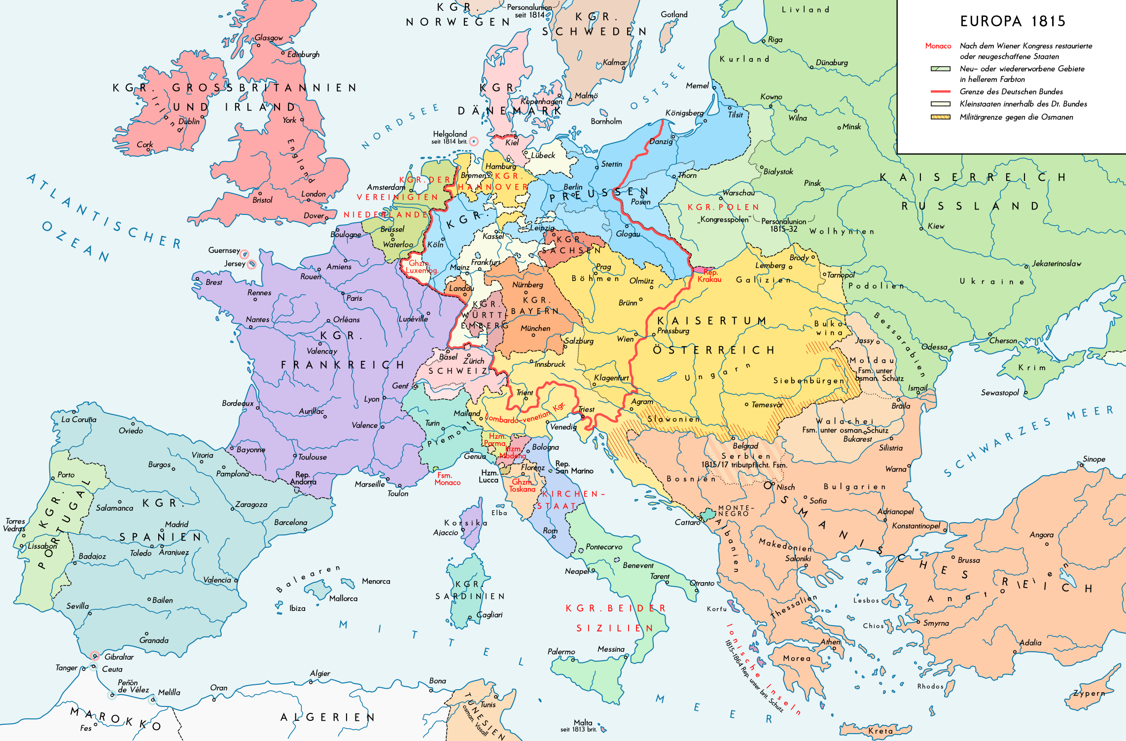
| 描述Europe 1815 map de.png |
English: Europe 1815. Political situation after the Congress of Vienna in June 1815. Please don't alter the map, when you think there something not written or depicted correctly. Leave a message at the talk page of the file. After a verificiation and a possible discussion, i will upload a new map version with all new changes. This prevents an unnecessary waste of disc space and ensure a good result, aesthetically and contentwise. - The author. Deutsch: Europa 1815. Politische Lage nach dem Wiener Kongress im Juni 1815. Bitte die Karte bei Änderungs- und Korrekturwünschen nicht selbst verändern, sondern eine Anmerkung im Diskussionsbereich der Bilddatei hinterlassen. Nach einer Prüfung und ggfs. Diskussion werden evtl. Änderungen von mir zusammengefasst eingearbeitet. Das vermeidet unnötige Speicherplatz-Verschwendung und gewährleistet ein ästhetisch ansprechendes und inhaltlich korrektes Ergebnis. - Der Urheber. |
| 日期 | |
| 來源 |
自己的作品. Source of Information: Historical atlases – Map "1815 - L'Europe apès le Congrès de Vienne" (Author unknown)(Link) – Ramsay Muir, George Philip (ed.): Philip's New School Atlas of Universal History, George Philip & Son, Ltd., London 1928 – Dr. Walter Leisering (ed.): Putzger Historischer Weltatlas, Cornelsen Verlag, Berlin 1992, ISBN 3-464-00176-8 – Bayerischer Schulbuch-Verlag (ed.): Großer Historischer Weltatlas, Dritter Teil, Neuzeit, Bayerischer Schulbuch-Verlag, München 1981, ISBN 3-7627-6021-7. – Prof. Dr. Hans-Erich Stier, Prof. Dr. Ernst Kirsten a. o. (ed.): Großer Atlas zur Weltgeschichte, Orbis Verlag, München 1990, ISBN 3-7627-6021-7 Other publications – Reinhard Stauber: Der Wiener Kongress, Böhlau Verlag, Wien/Köln/Weimar 2014, ISBN 978-3-8252-4095-0 – Thierry Lentz: 1815. Der Wiener Kongress und die Neugründung Europas, Siedler Verlag, München 2014, ISBN 978-3-8275-0027-4 |
| 作者 | Alexander Altenhof |
| 其他版本 |
|

Recompressed without quality loss with OptiPNG (1.36 MB > 1.06 MB)
授權條款
此檔案採用創用CC 姓名標示-相同方式分享 4.0 國際授權條款。
- 您可以自由:
- 分享 – 複製、發佈和傳播本作品
- 重新修改 – 創作演繹作品
- 惟需遵照下列條件:
- 姓名標示 – 您必須指名出正確的製作者,和提供授權條款的連結,以及表示是否有對內容上做出變更。您可以用任何合理的方式來行動,但不得以任何方式表明授權條款是對您許可或是由您所使用。
- 相同方式分享 – 如果您利用本素材進行再混合、轉換或創作,您必須基於如同原先的相同或兼容的條款,來分布您的貢獻成品。

|
本圖片是以PNG、GIF或JPEG格式上傳。然而,其中包含的資料或訊息,應該重新建立成可縮放向量圖形(SVG)檔案,以更有效率或更準確的方式儲存。如有可能,請上傳本圖片的SVG格式版本。在上傳之後,請修改維基各姊妹計畫中所有使用舊版圖片的條目(列在圖像連結章節中),替換為新版圖片,並在舊圖片的描述頁中加入{{Vector version available|新圖片名稱.svg}}模板,同時移除本模板。
|
說明
添加單行說明來描述出檔案所代表的內容
在此檔案描寫的項目
描繪內容
沒有維基數據項目的某些值
20 7 2016
檔案歷史
點選日期/時間以檢視該時間的檔案版本。
| 日期/時間 | 縮圖 | 尺寸 | 使用者 | 備註 | |
|---|---|---|---|---|---|
| 目前 | 2017年4月14日 (五) 23:37 | | 2,284 × 1,503(1.07 MB) | KaterBegemot | Minor changes |
| 2016年9月11日 (日) 21:51 |  | 2,284 × 1,503(1.35 MB) | KaterBegemot | Kingdom of Spain same green color like in the other maps | |
| 2016年9月11日 (日) 21:39 |  | 2,284 × 1,503(1.06 MB) | KaterBegemot | Deleted black border at Austrian part of the German Confederation border, P. of Monaco smaller, corrected border at Tarnopol area, changed spacing of K. of Netherlands text | |
| 2016年7月20日 (三) 11:28 |  | 2,284 × 1,503(1.06 MB) | KaterBegemot | {{Information |Description ={{en|1=Europe 1815. Political situation after the Congress of Vienna in June 1815.<br> ''Please don't alter the map, when you think there something not written or depicted correclty. Leave a mes... |
檔案用途
沒有使用此檔案的頁面。
全域檔案使用狀況
以下其他 wiki 使用了這個檔案:
- bg.wikipedia.org 的使用狀況
- de.wikipedia.org 的使用狀況
- lv.wikipedia.org 的使用狀況
- pt.wikipedia.org 的使用狀況
詮釋資料
此檔案中包含其他資訊,這些資訊可能是由數位相機或掃描器在建立或數位化過程中所新增的。若檔案自原始狀態已被修改,一些詳細資料可能無法完整反映出已修改的檔案。
| 水平解析度 | 70 dpi |
|---|---|
| 垂直解析度 | 70 dpi |
| 色彩空間 | 顏色未校準 |
| 影像寬度 | 2,284 px |
| 影像高度 | 1,503 px |
| 使用軟體 | Adobe Photoshop CC 2017 (Windows) |
| 數位化的日期時間 | 2017年4月15日 (六) 00:31 |
| 檔案修改日期時間 | 2017年4月15日 (六) 03:16 |
| 詮釋資料最後修改日期 | 2017年4月15日 (六) 03:16 |
| 原始文件唯一識別碼 | xmp.did:42cb4f16-85a2-0644-8c5d-9648733bc557 |