热门问题
时间线
聊天
视角
哥倫比亞河峽谷
来自维基百科,自由的百科全书

Remove ads
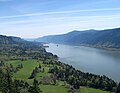
哥倫比亞河峽谷(英語:Columbia River Gorge)是位於美國太平洋西北地區哥倫比亞河的一個峽谷。峽谷最深處達到4,000英尺(1,200公尺),長度超過 80英里(130公里), 隨著哥倫比亞河蜿蜒穿過喀斯喀特山脈,是其北岸華盛頓州和南岸俄勒岡州的自然邊界。哥倫比亞河峽谷的起始點為Deschutes河與哥倫比亞河交匯處,向西一直到達波特蘭市區。哥倫比亞河峽谷是穿過喀斯喀特山脈、連接哥倫比亞高原(Columbia Plateau)和太平洋的唯一水運通道。

Remove ads
圖集
-
 Crown Point in the Columbia River Gorge, looking upstream from Chanticleer Point.
 -
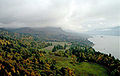 Columbia River Gorge, photographed from the southern edge of the Gifford Pinchot National Forest.
 -
 The view east towards The Dalles from Dog Mountain.
 -
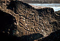 Native Indian petroglyphs in the Columbia River Gorge near The Dalles Dam.
 -
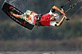 Kitesurfing on the Columbia River.
 -
 View of Columbia River Gorge from Cape Horn Trail, looking east toward Beacon Rock.
 -
 Columbia River Gorge, photographed from Crown point.
 -
 Triple Falls
 -
 Oneonta Creek


Remove ads
參考文獻
外部連結
- U.S. Forest Service(頁面存檔備份,存於網際網路檔案館) - Columbia River Gorge National Scenic Area
- Columbia River Gorge Commission(頁面存檔備份,存於網際網路檔案館)
- Columbia Gorge Magazine(頁面存檔備份,存於網際網路檔案館)
- Template:Oregon Encyclopedia
- Portland State University Columbia River Gorge National Scenic Area Collection—contains research material used to write the book Planning a New West: The Columbia River Gorge National Scenic Area
Template:Columbia River Template:Ice Age Floods Template:Oregon
Template:Protected Areas of Oregon
Wikiwand - on
Seamless Wikipedia browsing. On steroids.
Remove ads