File:Europe_1815_map_de.png
維基百科,自由的 encyclopedia
本预览的尺寸:800 × 526像素。 其他分辨率:320 × 211像素 | 640 × 421像素 | 1,024 × 674像素 | 1,280 × 842像素 | 2,284 × 1,503像素。
原始文件 (2,284 × 1,503像素,文件大小:1.07 MB,MIME类型:image/png)
摘要
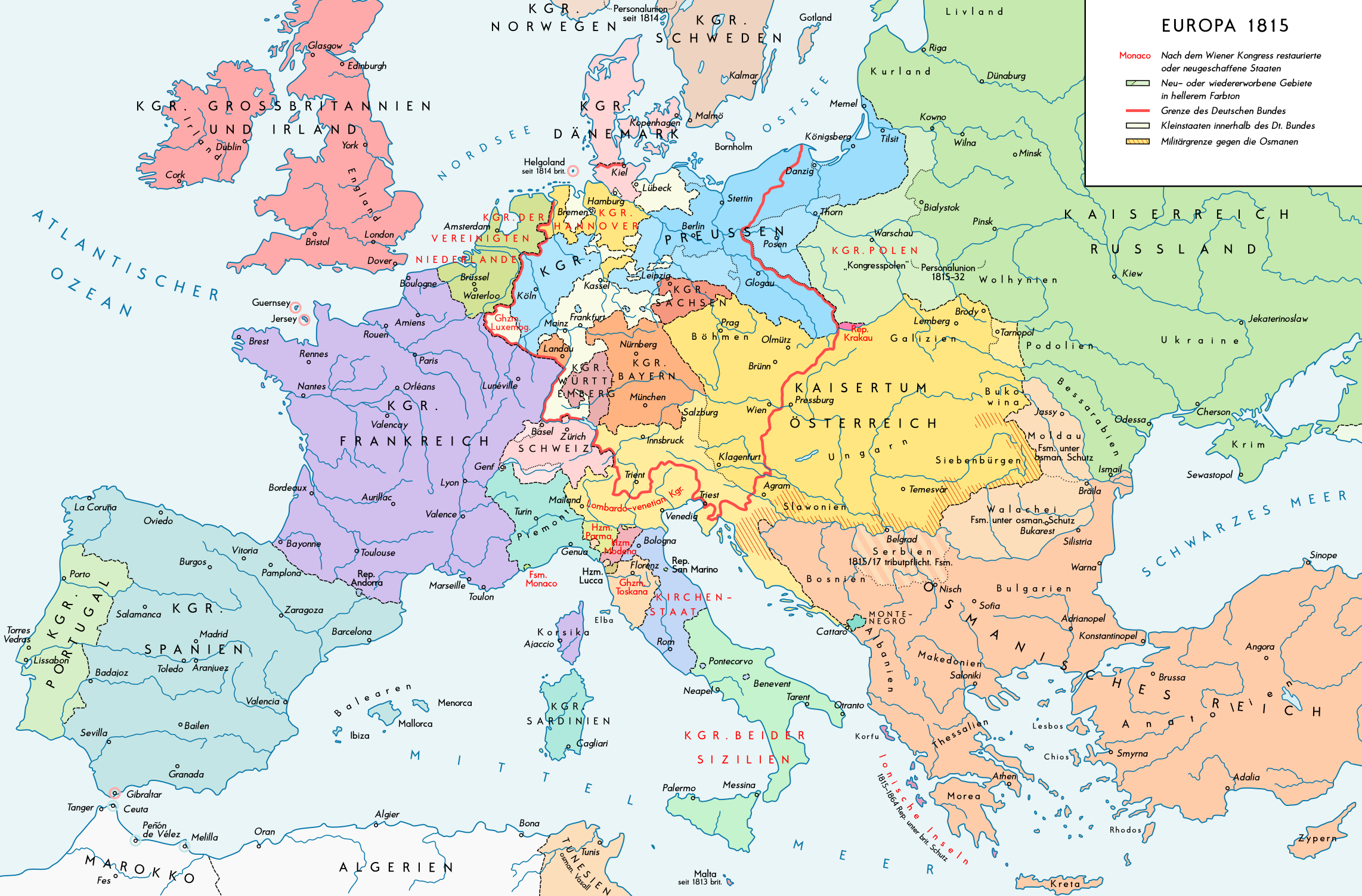
| 描述Europe 1815 map de.png |
English: Europe 1815. Political situation after the Congress of Vienna in June 1815. Please don't alter the map, when you think there something not written or depicted correctly. Leave a message at the talk page of the file. After a verificiation and a possible discussion, i will upload a new map version with all new changes. This prevents an unnecessary waste of disc space and ensure a good result, aesthetically and contentwise. - The author. Deutsch: Europa 1815. Politische Lage nach dem Wiener Kongress im Juni 1815. Bitte die Karte bei Änderungs- und Korrekturwünschen nicht selbst verändern, sondern eine Anmerkung im Diskussionsbereich der Bilddatei hinterlassen. Nach einer Prüfung und ggfs. Diskussion werden evtl. Änderungen von mir zusammengefasst eingearbeitet. Das vermeidet unnötige Speicherplatz-Verschwendung und gewährleistet ein ästhetisch ansprechendes und inhaltlich korrektes Ergebnis. - Der Urheber. |
| 日期 | |
| 来源 |
自己的作品. Source of Information: Historical atlases – Map "1815 - L'Europe apès le Congrès de Vienne" (Author unknown)(Link) – Ramsay Muir, George Philip (ed.): Philip's New School Atlas of Universal History, George Philip & Son, Ltd., London 1928 – Dr. Walter Leisering (ed.): Putzger Historischer Weltatlas, Cornelsen Verlag, Berlin 1992, ISBN 3-464-00176-8 – Bayerischer Schulbuch-Verlag (ed.): Großer Historischer Weltatlas, Dritter Teil, Neuzeit, Bayerischer Schulbuch-Verlag, München 1981, ISBN 3-7627-6021-7. – Prof. Dr. Hans-Erich Stier, Prof. Dr. Ernst Kirsten a. o. (ed.): Großer Atlas zur Weltgeschichte, Orbis Verlag, München 1990, ISBN 3-7627-6021-7 Other publications – Reinhard Stauber: Der Wiener Kongress, Böhlau Verlag, Wien/Köln/Weimar 2014, ISBN 978-3-8252-4095-0 – Thierry Lentz: 1815. Der Wiener Kongress und die Neugründung Europas, Siedler Verlag, München 2014, ISBN 978-3-8275-0027-4 |
| 作者 | Alexander Altenhof |
| 其他版本 |
|

Recompressed without quality loss with OptiPNG (1.36 MB > 1.06 MB)
许可协议
本文件采用知识共享署名-相同方式共享 4.0 国际许可协议授权。
- 您可以自由地:
- 共享 – 复制、发行并传播本作品
- 修改 – 改编作品
- 惟须遵守下列条件:
- 署名 – 您必须对作品进行署名,提供授权条款的链接,并说明是否对原始内容进行了更改。您可以用任何合理的方式来署名,但不得以任何方式表明许可人认可您或您的使用。
- 相同方式共享 – 如果您再混合、转换或者基于本作品进行创作,您必须以与原先许可协议相同或相兼容的许可协议分发您贡献的作品。

|
此map图片可使用矢量图形重新创建为SVG文件。这具有很多好处;更多信息请参见共享资源:待清理媒体。如果存在此图片的SVG格式,请将其上传,然后将此模板替换为
{{vector version available|新图片名称}}。
建议您将SVG命名为“Europe 1815 map de.svg”,这样在使用Vector version available(或Vva)模板时就不需要填写新图片名称参数。 |
说明
添加一行文字以描述该文件所表现的内容
此文件中描述的项目
描繪內容
某些值没有维基数据项目
20 7 2016
文件历史
点击某个日期/时间查看对应时刻的文件。
| 日期/时间 | 缩略图 | 大小 | 用户 | 备注 | |
|---|---|---|---|---|---|
| 当前 | 2017年4月14日 (五) 23:37 | | 2,284 × 1,503(1.07 MB) | KaterBegemot | Minor changes |
| 2016年9月11日 (日) 21:51 |  | 2,284 × 1,503(1.35 MB) | KaterBegemot | Kingdom of Spain same green color like in the other maps | |
| 2016年9月11日 (日) 21:39 |  | 2,284 × 1,503(1.06 MB) | KaterBegemot | Deleted black border at Austrian part of the German Confederation border, P. of Monaco smaller, corrected border at Tarnopol area, changed spacing of K. of Netherlands text | |
| 2016年7月20日 (三) 11:28 |  | 2,284 × 1,503(1.06 MB) | KaterBegemot | {{Information |Description ={{en|1=Europe 1815. Political situation after the Congress of Vienna in June 1815.<br> ''Please don't alter the map, when you think there something not written or depicted correclty. Leave a mes... |
文件用途
没有页面链接到本图像。
全域文件用途
以下其他wiki使用此文件:
- bg.wikipedia.org上的用途
- de.wikipedia.org上的用途
- lv.wikipedia.org上的用途
- pt.wikipedia.org上的用途
元数据
此文件中包含有扩展的信息。这些信息可能是由数码相机或扫描仪在创建或数字化过程中所添加。
如果此文件的源文件已经被修改,一些信息在修改后的文件中将不能完全反映出来。
| 水平分辨率 | 70 dpi |
|---|---|
| 垂直分辨率 | 70 dpi |
| 色彩空间 | 未标定 |
| 图像宽度 | 2,284 px |
| 图像高度 | 1,503 px |
| 使用软件 | Adobe Photoshop CC 2017 (Windows) |
| 数字化日期时间 | 2017年4月15日 (六) 00:31 |
| 文件修改日期时间 | 2017年4月15日 (六) 03:16 |
| 元数据最后修改日期 | 2017年4月15日 (六) 03:16 |
| 原始文件唯一ID | xmp.did:42cb4f16-85a2-0644-8c5d-9648733bc557 |