File:OttomanEmpireIn1683tr.png
維基百科,自由的 encyclopedia
本预览的尺寸:637 × 599像素。 其他分辨率:255 × 240像素 | 510 × 480像素 | 816 × 768像素 | 1,088 × 1,024像素 | 1,966 × 1,850像素。
原始文件 (1,966 × 1,850像素,文件大小:327 KB,MIME类型:image/png)
摘要
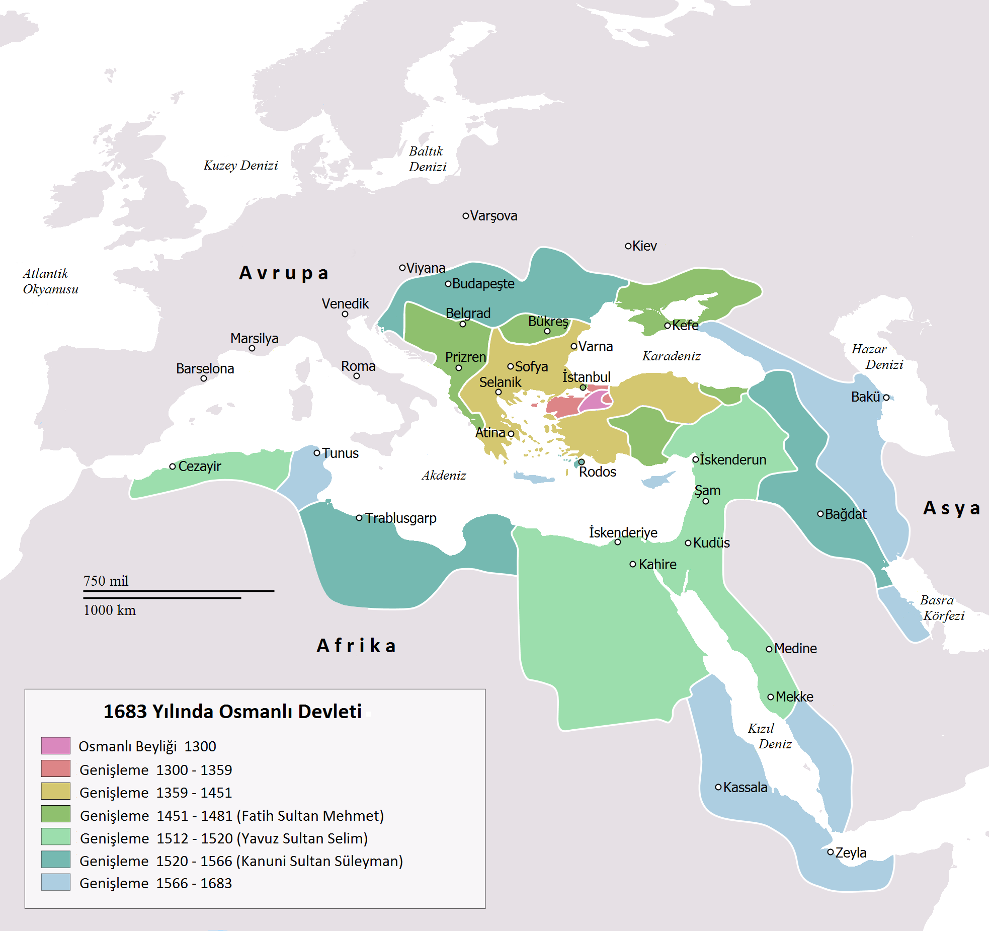
| 描述OttomanEmpireIn1683tr.png |
English: Map depicting the Ottoman Empire at its greatest extent, in 1683.
Türkçe: 1683 yılına gelindiğinde Osmanlı İmparatorluğu haritası |
| 日期 | |
| 来源 | Self drawn, mainly based on Robert Mantran (ed.), Histoire de l'Empire Ottoman, Paris: Fayard (1989), also en:List of Ottoman Empire dominated territories, Image:Ottoman 1683.png, [1], and [2]. Background map modified from Image:A large blank world map with oceans marked in blue.svg. |
| 作者 | Atilim Gunes Baydin yapımı, Osmanlı98 Türkçeye çevirdi. |
| 其他版本 |
[编辑]
|


许可协议
| Public domainPublic domainfalsefalse |
| 我,本作品著作权人,释出本作品至公有领域。这适用于全世界。 在一些国家这可能不合法;如果是这样的话,那么: 我无条件地授予任何人以任何目的使用本作品的权利,除非这些条件是法律规定所必需的。 |
说明
添加一行文字以描述该文件所表现的内容
此文件中描述的项目
描繪內容
著作权持有者释出至公有领域 简体中文(已转写)
7 2 2010
文件历史
点击某个日期/时间查看对应时刻的文件。
| 日期/时间 | 缩略图 | 大小 | 用户 | 备注 | |
|---|---|---|---|---|---|
| 当前 | 2016年11月14日 (一) 22:15 | | 1,966 × 1,850(327 KB) | Gündoğdu | New version.High image quality |
| 2010年2月28日 (日) 16:23 |  | 637 × 599(101 KB) | Osmanlı98 | Cezayir=Trablus | |
| 2010年2月7日 (日) 13:04 |  | 637 × 599(100 KB) | Osmanlı98 | {{Information |Description={{en|1=Map depicting the Ottoman Empire at its greatest extent, in 1683.}} {{tr|1=1683 yılına gelindiğinde Osmanlı İmparatorluğu haritası}} |Source=Self drawn, mainly based on ''Robert Mantran (ed.), Histoire de l'Empire |
文件用途
没有页面链接到本图像。
全域文件用途
以下其他wiki使用此文件:
- az.wikipedia.org上的用途
- tr.wikipedia.org上的用途
- ug.wikipedia.org上的用途
元数据
此文件中包含有扩展的信息。这些信息可能是由数码相机或扫描仪在创建或数字化过程中所添加。
如果此文件的源文件已经被修改,一些信息在修改后的文件中将不能完全反映出来。
| 水平分辨率 | 37.8 dpc |
|---|---|
| 垂直分辨率 | 37.8 dpc |