Portal:Geography
Wikipedia portal for content related to Geography / From Wikipedia, the free encyclopedia
Portal maintenance status: (February 2020)
|
Other vital articles |
|---|
More featured biographies |
|---|
The Geography Portal

Geography (from Ancient Greek γεωγραφία geōgraphía; combining gê 'Earth' and gráphō 'write') is the study of the lands, features, inhabitants, and phenomena of Earth. Geography is an all-encompassing discipline that seeks an understanding of Earth and its human and natural complexities—not merely where objects are, but also how they have changed and come to be. While geography is specific to Earth, many concepts can be applied more broadly to other celestial bodies in the field of planetary science. Geography has been called "a bridge between natural science and social science disciplines."
Origins of many of the concepts in geography can be traced to Greek Eratosthenes of Cyrene, who may have coined the term "geographia" (c. 276 BC – c. 195/194 BC). The first recorded use of the word γεωγραφία was as the title of a book by Greek scholar Claudius Ptolemy (100 – 170 AD). This work created the so-called "Ptolemaic tradition" of geography, which included "Ptolemaic cartographic theory." However, the concepts of geography (such as cartography) date back to the earliest attempts to understand the world spatially, with the earliest example of an attempted world map dating to the 9th century BCE in ancient Babylon. The history of geography as a discipline spans cultures and millennia, being independently developed by multiple groups, and cross-pollinated by trade between these groups. The core concepts of geography consistent between all approaches are a focus on space, place, time, and scale.
Today, geography is an extremely broad discipline with multiple approaches and modalities. There have been multiple attempts to organize the discipline, including the four traditions of geography, and into branches. Techniques employed can generally be broken down into quantitative and qualitative approaches, with many studies taking mixed-methods approaches. Common techniques include cartography, remote sensing, interviews, and surveying. (Full article...)
 Featured article - load new batch
![Image 1Mauna Kea in December 2007, with its seasonal snow cap visibleMauna Kea (/ˌmɔːnə ˈkeɪə/ or /ˌmaʊnə ˈkeɪə/; Hawaiian: [ˈmɐwnə ˈkɛə]; abbreviation for Mauna a Wākea) is an inactive shield volcano on the island of Hawaiʻi. Its peak is 4,207.3 m (13,803 ft) above sea level, making it the highest point in Hawaii and second-highest peak of an island on Earth. The peak is about 38 m (125 ft) higher than Mauna Loa, its more massive neighbor. Mauna Kea is unusually topographically prominent for its height: its wet prominence is fifteenth in the world among mountains, at 4,205 m (13,796 ft); its dry prominence is 9,330 m (30,610 ft). This dry prominence is greater than Mount Everest's height above sea level of 8,848.86 m (29,032 ft), and some authorities have labeled Mauna Kea the tallest mountain in the world, from its underwater base. Mauna Kea is ranked 8th by topographic isolation.It is about one million years old and thus passed the most active shield stage of life hundreds of thousands of years ago. In its current post-shield state, its lava is more viscous, resulting in a steeper profile. Late volcanism has also given it a much rougher appearance than its neighboring volcanoes due to construction of cinder cones, decentralization of its rift zones, glaciation on its peak, and weathering by the prevailing trade winds. Mauna Kea last erupted 6,000 to 4,000 years ago and is now thought to be dormant. (Full article...)](//upload.wikimedia.org/wikipedia/en/d/d2/Blank.png) Image 1
Image 1 Mauna Kea in December 2007, with its seasonal snow cap visible
Mauna Kea (/ˌmɔːnə ˈkeɪə/ or /ˌmaʊnə ˈkeɪə/; Hawaiian: [ˈmɐwnə ˈkɛə]; abbreviation for Mauna a Wākea) is an inactive shield volcano on the island of Hawaiʻi. Its peak is 4,207.3 m (13,803 ft) above sea level, making it the highest point in Hawaii and second-highest peak of an island on Earth. The peak is about 38 m (125 ft) higher than Mauna Loa, its more massive neighbor. Mauna Kea is unusually topographically prominent for its height: its wet prominence is fifteenth in the world among mountains, at 4,205 m (13,796 ft); its dry prominence is 9,330 m (30,610 ft). This dry prominence is greater than Mount Everest's height above sea level of 8,848.86 m (29,032 ft), and some authorities have labeled Mauna Kea the tallest mountain in the world, from its underwater base. Mauna Kea is ranked 8th by topographic isolation.
It is about one million years old and thus passed the most active shield stage of life hundreds of thousands of years ago. In its current post-shield state, its lava is more viscous, resulting in a steeper profile. Late volcanism has also given it a much rougher appearance than its neighboring volcanoes due to construction of cinder cones, decentralization of its rift zones, glaciation on its peak, and weathering by the prevailing trade winds. Mauna Kea last erupted 6,000 to 4,000 years ago and is now thought to be dormant. (Full article...)- Image 2
General Gregor MacGregor (24 December 1786 – 4 December 1845) was a Scottish soldier, adventurer, and confidence trickster who attempted from 1821 to 1837 to draw British and French investors and settlers to "Poyais", a fictional Central American territory that he claimed to rule as "Cazique". Hundreds invested their savings in supposed Poyaisian government bonds and land certificates, while about 250 emigrated to MacGregor's invented country in 1822–23 to find only an untouched jungle; more than half of them died. Seen as a contributory factor to the "Panic of 1825", MacGregor's Poyais scheme has been called one of the most brazen confidence tricks in history.
From the Clan Gregor, MacGregor was an officer in the British Army from 1803 to 1810; he served in the Peninsular War. He joined the republican side in the Venezuelan War of Independence in 1812, quickly became a general and, over the next four years, operated against the Spanish on behalf of both Venezuela and its neighbour New Granada. His successes included a difficult month-long fighting retreat through northern Venezuela in 1816. He captured Amelia Island in 1817 under a mandate from revolutionary agents to conquer Florida from the Spanish, and there proclaimed a short-lived "Republic of the Floridas". He then oversaw two calamitous operations in New Granada during 1819 that each ended with his abandoning British volunteer troops under his command. (Full article...) - Image 3
 Sunset on Ganoga Lake
Ganoga Lake is a natural lake in Colley Township in southeastern Sullivan County in Pennsylvania, United States. Known as Robinson's Lake and Long Pond for most of the 19th century, the lake was purchased by the Ricketts family in the early 1850s and became part of R. Bruce Ricketts' extensive holdings in the area after the American Civil War. The lake is one of the highest in Pennsylvania, which led Ricketts to name it Highland Lake by 1874 and rename it Ganoga Lake in 1881; Pennsylvania senator Charles R. Buckalew suggested the name Ganoga from the Seneca language word for "water on the mountain".
The Ricketts built a stone house on the lake shore by 1852 or 1855; this served as a hunting lodge and tavern. In 1873 a large wooden addition was built north of the stone house, which became a hotel known as the North Mountain House. The hotel had one of the first summer schools in the United States in 1876 and 1877. A branch railroad line to the lake served the hotel and also hauled ice cut from the lake for refrigeration. The hotel closed in 1903, though the house remained the Ricketts family summer home. After the death of R. Bruce Ricketts in 1918, his heirs sold much of his 80,000 acres (32,000 ha) to the state for Pennsylvania State Game Lands and Ricketts Glen State Park. The state tried to purchase the lake in 1957, but was outbid by a group of investors who turned the land around it into a private housing development; as such it is "off limits" to the public. (Full article...) - Image 4
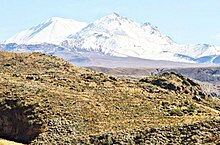 Tutupaca viewed from a southern direction.
Tutupaca is a volcano in the region of Tacna in Peru. It is part of the Peruvian segment of the Central Volcanic Zone, one of several volcanic belts in the Andes. Tutupaca consists of three overlapping volcanoes formed by lava flows and lava domes made out of andesite and dacite, which grew on top of older volcanic rocks. The highest of these is usually reported to be 5,815 metres (19,078 ft) tall and was glaciated in the past.
Several volcanoes in Peru have been active in recent times, including Tutupaca. Their volcanism is caused by the subduction of the Nazca Plate beneath the South America Plate. One of these volcanoes collapsed in historical time, probably in 1802, generating a large debris avalanche with a volume likely exceeding 0.6–0.8 cubic kilometres (0.14–0.19 cu mi) and a pyroclastic flow. The associated eruption was among the largest in Peru for which there are historical records. The volcano became active about 700,000 years ago, and activity continued into the Holocene, but whether there were historical eruptions was initially unclear; some eruptions were instead attributed to the less eroded Yucamane volcano. The Peruvian government plans to monitor the volcano for future activity. Tutupaca features geothermal manifestations with fumaroles and hot springs. (Full article...) - Image 5
 View of Barren Island from Dead Horse Bay
Barren Island is a peninsula and former island on the southeast shore of Brooklyn in New York City. Located on Jamaica Bay, it was geographically part of the Outer Barrier island group on the South Shore of Long Island. The island was occupied by the Lenape Native Americans prior to the arrival of Dutch settlers in the 17th century. Its name is a corruption of Beeren Eylandt, the Dutch-language term for "Bears' Island".
Barren Island remained sparsely inhabited before the 19th century, mainly because of its relative isolation from the rest of the city. Starting in the 1850s, the island was developed as an industrial complex with fish rendering plants and other industries, and also as an ethnically diverse community of up to 1,500 residents. Between the mid-19th century and 1934, the island housed industrial plants that processed the carcasses of the city's dead horses, converting them into a variety of industrial products. This activity led to the still-extant waterbody on the island's western shore becoming nicknamed "Dead Horse Bay". A garbage incinerator, which became the subject of numerous complaints because of its odor, operated on the island from the 1890s to 1921. (Full article...) - Image 6
The House of Plantagenet (/plænˈtædʒənət/ plan-TAJ-ə-nət) was a royal house which originated in the French County of Anjou. The name Plantagenet is used by modern historians to identify four distinct royal houses: the Angevins, who were also counts of Anjou; the main line of the Plantagenets following the loss of Anjou; and the Houses of Lancaster and York, two of the Plantagenets cadet branches. The family held the English throne from 1154, with the accession of Henry II, until 1485, when Richard III died.
Under the Plantagenets, England was transformed, although this was only partly intentional. The Plantagenet kings were often forced to negotiate compromises such as Magna Carta, which constrained royal power in return for financial and military support. The king was no longer just the most powerful man in the nation, holding the prerogative of judgement, feudal tribute and warfare, but had defined duties to the realm, underpinned by a sophisticated justice system. A distinct national identity was shaped by their conflict with the French, Scots, Welsh and Irish, as well as by the establishment of Middle English as the primary language. (Full article...) - Image 7

Japan is an island country in East Asia. It is in the northwest Pacific Ocean and is bordered on the west by the Sea of Japan, extending from the Sea of Okhotsk in the north toward the East China Sea, Philippine Sea, and Taiwan in the south. Japan is a part of the Ring of Fire, and spans an archipelago of 14,125 islands, with the four main islands being Hokkaido, Honshu (the "mainland"), Shikoku, and Kyushu. Tokyo is the country's capital and largest city, followed by Yokohama, Osaka, Nagoya, Sapporo, Fukuoka, Kobe, and Kyoto.
The Japanese archipelago has been inhabited since the Upper Paleolithic (30,000 BC). Between the fourth and ninth centuries AD, the kingdoms of the region became unified under an emperor and the imperial court based in Heian-kyō. Beginning in the 12th century, political power was held by a series of military dictators (shōgun) and feudal lords (daimyō), and enforced by a class of warrior nobility (samurai). After a century-long period of civil war, the country was reunified in 1603 under the Tokugawa shogunate, which enacted an isolationist foreign policy. In 1854, a United States fleet forced Japan to open trade to the West, which led to the end of the shogunate and the restoration of imperial power in 1868. In the Meiji period, the Empire of Japan adopted a Western-modeled constitution, and pursued a program of industrialization and modernization. Amidst a rise in militarism and overseas colonization, Japan invaded China in 1937 and entered World War II as an Axis power in 1941. After suffering defeat in the Pacific War and two atomic bombings, Japan surrendered in 1945 and came under a seven-year Allied occupation, during which it adopted a new constitution. (Full article...) - Image 8
 Column of Armenian deportees guarded by gendarmes in Harput vilayet
The Armenian genocide was the systematic destruction of the Armenian people and identity in the Ottoman Empire during World War I. Spearheaded by the ruling Committee of Union and Progress (CUP), it was implemented primarily through the mass murder of around one million Armenians during death marches to the Syrian Desert and the forced Islamization of others, primarily women and children.
Before World War I, Armenians occupied a somewhat protected, but subordinate, place in Ottoman society. Large-scale massacres of Armenians had occurred in the 1890s and 1909. The Ottoman Empire suffered a series of military defeats and territorial losses—especially during the 1912–1913 Balkan Wars—leading to fear among CUP leaders that the Armenians would seek independence. During their invasion of Russian and Persian territory in 1914, Ottoman paramilitaries massacred local Armenians. Ottoman leaders took isolated instances of Armenian resistance as evidence of a widespread rebellion, though no such rebellion existed. Mass deportation was intended to permanently forestall the possibility of Armenian autonomy or independence. (Full article...) - Image 9
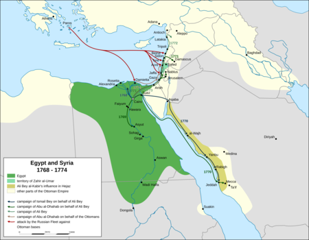
Extent of Ali Bey and Zahir's territory between 1768 and 1774 and Russian naval movements in the Levant, based on the accounts of Sauveur Lusignan, a contemporary historian
Beirut was twice occupied during the Russo-Turkish War of 1768–1774 by squadrons of the Imperial Russian Navy's Mediterranean Fleet, first in June 1772 and second from October 1773 to early 1774, as part of its Levant campaign. Russia's main objective in this campaign was to assist local forces led by Egypt's autonomous ruler, Ali Bey al-Kabir, who was in open rebellion against the Ottoman Empire.
Russia, led by Catherine the Great, was pressing the Ottomans in Europe. Ali took advantage of the Empire's preoccupation with Russia to declare Egypt's independence; in 1771 he sent an army led by Muhammad Bey Abu al-Dhahab to occupy Ottoman territory in the Levant. Abu al-Dhahab unexpectedly returned to challenge Ali for control of Egypt. Ali requested Russian military assistance against both his rival and the Ottomans. When this aid, in the form of a small Russian squadron, arrived in the region, Ali had already fled Egypt and taken refuge in Acre, the power base of his ally, Zahir al-Umar. After helping repel an Ottoman offensive on Sidon, the Russian squadron sailed for Beirut. They bombarded the town in June 1772 and occupied it from June 23 to 28. (Full article...) - Image 10

Micronations and the Search for Sovereignty is a 2021 book by Australian constitutional law specialists Harry Hobbs and George Williams about micronations and their legal status. Written from an academic perspective, it is one of few works on micronational movements and the earliest-published book to focus largely on the legal aspect of micronations. The book concerns the definition of statehood, the place of micronations within international law, people's motivations for declaring them, the micronational community and the ways by which such entities mimic sovereign states. In 2022 Hobbs and Williams published a book for a broader audience, How to Rule Your Own Country: The Weird and Wonderful World of Micronations. (Full article...) - Image 11
 Fanno Creek in Greenway Park, Beaverton
Fanno Creek is a 15-mile (24 km) tributary of the Tualatin River in the U.S. state of Oregon. Part of the drainage basin of the Columbia River, its watershed covers about 32 square miles (83 km2) in Multnomah, Washington, and Clackamas counties, including about 7 square miles (18 km2) within the Portland city limits.
From its headwaters in the Tualatin Mountains (West Hills) in southwest Portland, the creek flows generally west and south through the cities of Portland, Beaverton, Tigard and Durham, and unincorporated areas of Washington County. It enters the Tualatin River about 9 miles (14 km) above the Tualatin's confluence with the Willamette River at West Linn. (Full article...) - Image 12

A map of Resolution Guyot's bathymetric relief
Resolution Guyot (formerly known as Huevo) is a guyot (tablemount) in the underwater Mid-Pacific Mountains in the Pacific Ocean. It is a circular flat mountain, rising 500 metres (1,600 ft) above the seafloor to a depth of about 1,320 metres (4,330 ft), with a 35-kilometre-wide (22 mi) summit platform. The Mid-Pacific Mountains lie west of Hawaii and northeast of the Marshall Islands, but at the time of its formation, the guyot was located in the Southern Hemisphere.
The guyot was probably formed by a hotspot in today's French Polynesia before plate tectonics shifted it to its present-day location. The Easter, Marquesas, Pitcairn and Society hotspots, among others, may have been involved in the formation of Resolution Guyot. Volcanic activity has been dated to have occurred 107–129 million years ago and formed a volcanic island that was subsequently flattened by erosion. Carbonate deposition commenced, forming an atoll-like structure and a carbonate platform. (Full article...) - Image 13
 Looking south across the reserve, with reed beds in the foreground
Ham Wall is an English wetland National Nature Reserve (NNR) 4 kilometres (2.5 mi) west of Glastonbury on the Somerset Levels. It is managed by the Royal Society for the Protection of Birds (RSPB). Since the last Ice Age, decomposing plants in the marshes of the Brue valley in Somerset have accumulated as deep layers of peat that were commercially exploited on a large scale in the twentieth century. Consumer demand eventually declined, and in 1994 the landowners, Fisons, gave their old workings to what is now Natural England, who passed the management of the 260 hectares (640 acres) Ham Wall section to the RSPB.
The Ham Wall reserve was constructed originally to provide reed bed habitat for the Eurasian bittern, which at the time was at a very low population level in the UK. The site is divided into several sections with independently controllable water levels, and machinery and cattle are used to maintain the quality of the reed beds. There are important breeding populations of wetland birds including the rare little bittern and great white egret, and the area hosts several other uncommon animals and plants. The RSPB works with other organisations as part of the Avalon Marshes Partnership to coordinate conservation issues across the Somerset Levels. (Full article...) - Image 14

The orca (Orcinus orca), or killer whale, is a toothed whale that is the largest member of the oceanic dolphin family. It is the only extant species in the genus Orcinus. Orcas are recognizable by their black-and-white patterned body. A cosmopolitan species, they are found in diverse marine environments, from Arctic to Antarctic regions to tropical seas.
Orcas are apex predators with a diverse diet. Individual populations often specialize in particular types of prey. This includes a variety of fish, sharks, rays, and marine mammals such as seals and other dolphins and whales. They are highly social; some populations are composed of highly stable matrilineal family groups (pods). Their sophisticated hunting techniques and vocal behaviors, often specific to a particular group and passed along from generation to generation, are considered to be manifestations of animal culture. (Full article...) - Image 15
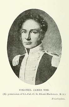 The frontispiece of the 1920 edition of Tod's Annals and Antiquities of Rajast'han
Lieutenant-Colonel James Tod (20 March 1782 – 18 November 1835) was an officer of the British East India Company and an Oriental scholar. He combined his official role and his amateur interests to create a series of works about the history and geography of India, and in particular the area then known as Rajputana that corresponds to the present day state of Rajasthan, and which Tod referred to as Rajast'han.
Tod was born in London and educated in Scotland. He joined the East India Company as a military officer and travelled to India in 1799 as a cadet in the Bengal Army. He rose quickly in rank, eventually becoming captain of an escort for an envoy in a Sindian royal court. After the Third Anglo-Maratha War, during which Tod was involved in the intelligence department, he was appointed Political Agent for some areas of Rajputana. His task was to help unify the region under the control of the East India Company. During this period Tod conducted most of the research that he would later publish. Tod was initially successful in his official role, but his methods were questioned by other members of the East India Company. Over time, his work was restricted and his areas of oversight were significantly curtailed. In 1823, owing to declining health and reputation, Tod resigned his post as Political Agent and returned to England. (Full article...)
![Image 1Mauna Kea in December 2007, with its seasonal snow cap visibleMauna Kea (/ˌmɔːnə ˈkeɪə/ or /ˌmaʊnə ˈkeɪə/; Hawaiian: [ˈmɐwnə ˈkɛə]; abbreviation for Mauna a Wākea) is an inactive shield volcano on the island of Hawaiʻi. Its peak is 4,207.3 m (13,803 ft) above sea level, making it the highest point in Hawaii and second-highest peak of an island on Earth. The peak is about 38 m (125 ft) higher than Mauna Loa, its more massive neighbor. Mauna Kea is unusually topographically prominent for its height: its wet prominence is fifteenth in the world among mountains, at 4,205 m (13,796 ft); its dry prominence is 9,330 m (30,610 ft). This dry prominence is greater than Mount Everest's height above sea level of 8,848.86 m (29,032 ft), and some authorities have labeled Mauna Kea the tallest mountain in the world, from its underwater base. Mauna Kea is ranked 8th by topographic isolation.It is about one million years old and thus passed the most active shield stage of life hundreds of thousands of years ago. In its current post-shield state, its lava is more viscous, resulting in a steeper profile. Late volcanism has also given it a much rougher appearance than its neighboring volcanoes due to construction of cinder cones, decentralization of its rift zones, glaciation on its peak, and weathering by the prevailing trade winds. Mauna Kea last erupted 6,000 to 4,000 years ago and is now thought to be dormant. (Full article...)](./File:Blank.png)


.svg)


 Vital article

Related portals
Get involved
 |
Here are some tasks awaiting attention:
|
Selected pictures
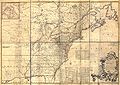 Image 1Author: John Mitchell; scan: Library of Congress, Geography and Map Division.The Mitchell Map is the most comprehensive map of eastern North America made during the colonial era. Measuring about 6.5 ft (2.0 m) wide by 4.5 ft (1.4 m) high, it was produced by John Mitchell in 1757 in eight separate sheets. The map was used during the Treaty of Paris for defining the boundaries of the United States, and remains important today for resolving border disputes.
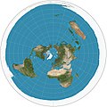 Image 2Map: Strebe, using GeocartThe azimuthal equidistant projection is an azimuthal map projection in which all points on the map are both proportionately correct distances from the center point and at the correct azimuth (direction) from the center point. Distances and directions to all places, however, are true only from the center point of projection. This projection has been used for the flag of the United Nations, for the USGS National Atlas of the United States of America, and for large-scale mapping of Micronesia, among others.
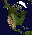 Image 3Photo: NASAA composite satellite image of the continent of North America in orthographic projection. North America occupies the northern portion of the landmass generally known as the Americas, with its southern border at the Darién watershed along the Colombia–Panama border. The vast majority of North America rests on the North American Plate, while small parts of California and western Mexico rest on the Pacific Plate; Central America and the Caribbean islands rest on the Caribbean Plate.
 Image 4Credit: Martin WaldseemüllerThe Waldseemüller map is a map drawn by German cartographer Martin Waldseemüller originally published in April 1507. It was one of the first maps to chart latitude and longitude precisely, the first map to use the name "America", and the first to depict the Americas as separate from Asia.
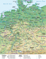 Image 5Map credit: Lencer and NordNordWestA general map, showing the geography of Germany, the seventh largest country in Europe and the second most populous. Located in Central Europe, Germany is second only to Russia in the number of borders it shares with other European countries (9).
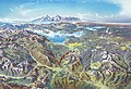 Image 6Map credit: Heinrich C. BerannYellowstone National Park is an American national park located mostly in Wyoming and extending into Montana and Idaho. It was established by the U.S. Congress and signed into law by President Ulysses S. Grant on March 1, 1872. Yellowstone was the first national park in the U.S. and is also widely held to be the first national park in the world. The park is known for its wildlife and its many geothermal features, especially the Old Faithful geyser, one of its most popular landmarks. It has many types of ecosystems, but the subalpine forest is the most abundant. The park is part of the South Central Rockies forests ecoregion. In 1978, Yellowstone was named a World Heritage Site by UNESCO.
This picture is a stylized panoramic map of Yellowstone National Park as viewed from the northeast, created in 1991 by Austrian painter and cartographer Heinrich C. Berann for the National Park Service. Yellowstone Lake and the Grand Canyon of the Yellowstone are in the center, while Old Faithful is visible on the right, next to a brown building representing the Old Faithful Inn. Jackson Lake and the peaks of the Teton Range are depicted in the background.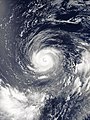 Image 7Typhoon Noru was the second-longest lasting tropical cyclone of the northwest Pacific Ocean on record. The fifth named storm of the 2017 Pacific typhoon season, it formed on July 19 and reached peak intensity on July 31 with 175 km/h (110 mph) 10-minute sustained winds. By this time, as shown in this satellite image, the typhoon was located south of Iwo Jima, and had taken on annular characteristics, with a symmetric ring of deep convection surrounding a 30 km (19 mi) well defined eye and fairly uniform cloud top temperatures. Traveling northwestward over an area of low ocean heat content, the eye became enlarged and ragged as the system weakened. By the time Noru made landfall over Wakayama Prefecture, Japan, on August 7, it had been downgraded to a severe tropical storm. It then dissipated over the Sea of Japan on August 9 as an extratropical cyclone.
 Image 8Map: Strebe, using GeocartA gnomonic projection of a portion of the northern hemisphere, centered on the geographic North Pole. Such projections display all great circles as straight lines, resulting in any line segment on a gnomonic map showing the shortest route between the segment's two endpoints.
 Image 9A world map entitled Nova totius terrarum orbis tabula Amstelodami, created in 1689 by Gerard van Schagen. This map, created in Amsterdam, measures 48.3 by 56.0 centimetres (19.0 by 22.0 in) in size and was made using copper engraving.
 Image 10Image: Chris RywaltAn animation showing the unfolding of a Dymaxion map, a projection of a world map onto the surface of a polyhedron (in this case, an icosahedron) and then flattened to form a two-dimensional map which retains most of the relative proportional integrity of the globe map. This type of map was invented by Buckminster Fuller and is one of several of his inventions to use the name Dymaxion.
 Image 11Photograph: Maull & Fox; restoration: Adam CuerdenFanny Bullock Workman (1859–1925) was an American geographer, cartographer, explorer, travel writer, and mountaineer. Together with her husband, William Hunter Workman, she traveled by bicycle through Switzerland, France, Italy, Spain, Algeria and India; after taking up climbing in the Himalayas, she set a women's altitude record on Pinnacle Peak, reaching 23,000 feet (7,000 m). She published eight travel books, with particular focus on the lives of women in the countries she visited, and championed women's rights and women's suffrage.
 Image 12Map: Strebe, using the Geocart map projection softwareA map of the world using the Natural Earth projection, a pseudocylindrical projection which is neither conformal nor equal-area. The projection was designed by Tom Patterson, an American cartographer with the National Park Service who has developed several open-source tools and base maps for cartographers.
This map is a derivative of NASA's Blue Marble summer month composite, with oceans lightened to enhance legibility and contrast. Image 13Map: Strebe, using GeocartThe Mollweide projection is an equal-area, pseudocylindrical map projection generally used for global maps of the world or night sky. The projection was first published by mathematician and astronomer Karl Mollweide of Leipzig in 1805 but reinvented and popularized in 1857 by Jacques Babinet. The projection trades accuracy of angle and shape for accuracy of proportions in area, and as such is used where that property is needed, such as maps depicting global distributions.
 Image 14Map: Strebe, using GeocartThe Albers projection is a conic, equal area map projection, named after Heinrich C. Albers, that uses two standard parallels. Although scale and shape are not preserved, distortion is minimal between the standard parallels. This map is used by such agencies as the United States Geological Survey, the United States Census Bureau, and the governments of British Columbia and Yukon.
 Image 15Map: Strebe, using GeocartThe Tobler hyperelliptical projection is a family of equal-area pseudocylindrical map projections first described by Waldo R. Tobler in 1973. The imagery used for the map is derived from NASA's Blue Marble summer months composite, with oceans lightened to enhance legibility and contrast.


Featured biography

Edward Drinker Cope (July 28, 1840 – April 12, 1897) was an American zoologist, paleontologist, comparative anatomist, herpetologist, and ichthyologist. Born to a wealthy Quaker family, he distinguished himself as a child prodigy interested in science, publishing his first scientific paper at the age of 19. Though his father tried to raise Cope as a gentleman farmer, he eventually acquiesced to his son's scientific aspirations.
Cope had little formal scientific training, and he eschewed a teaching position for field work. He made regular trips to the American West, prospecting in the 1870s and 1880s, often as a member of U.S. Geological Survey teams. A personal feud between Cope and paleontologist Othniel Charles Marsh led to a period of intense fossil-finding competition now known as the Bone Wars. Cope's financial fortunes soured after failed mining ventures in the 1880s, forcing him to sell off much of his fossil collection. He experienced a resurgence in his career toward the end of his life before dying on April 12, 1897. (Full article...)Did you know
- ... that glaciation in Wisconsin 17 thousand years ago helped create its unique geography?
- ... that Johann Reinhold Forster's 1778 book Observations Made During a Voyage Round the World has been described as "the beginning of modern geography"?
Places around you
Top 10 WikiProject Geography Popular articles of the month
- Image 1

A map of the United States showing its 50 states, federal district and five inhabited territories. Alaska, Hawaii, and the territories are shown at different scales, and the Aleutian Islands and the uninhabited northwestern Hawaiian Islands are omitted from this map.
The United States of America is a federal republic consisting of 50 states, a federal district (Washington, D.C., the capital city of the United States), five major territories, and various minor islands. Both the states and the United States as a whole are each sovereign jurisdictions. The Tenth Amendment to the United States Constitution allows states to exercise all powers of government not delegated to the federal government. Each state has its own constitution and government, and all states and their residents are represented in the federal Congress, a bicameral legislature consisting of the Senate and the House of Representatives. Each state is represented by two senators, while representatives are distributed among the states in proportion to the most recent constitutionally mandated decennial census. Additionally, each state is entitled to select a number of electors to vote in the Electoral College, the body that elects the president of the United States, equal to the total of representatives and senators in Congress from that state. The federal district does not have representatives in the Senate, but has a non-voting delegate in the House, and it is also entitled to electors in the Electoral College. Congress can admit more states, but it cannot create a new state from territory of an existing state or merge two or more states into one without the consent of all states involved, and each new state is admitted on an equal footing with the existing states. (Full article...) - Image 2Generation Z (often shortened to Gen Z), colloquially known as Zoomers, is the demographic cohort succeeding Millennials and preceding Generation Alpha. Researchers and popular media use the mid-to-late 1990s as starting birth years and the early 2010s as ending birth years. Most members of Generation Z are the children of Generation X or older Millennials. (Full article...)
- Image 3
 The Blue Marble, Apollo 17, December 1972
Earth is the third planet from the Sun and the only astronomical object known to harbor life. This is enabled by Earth being a water world, the only one in the Solar System sustaining liquid surface water. Almost all of Earth's water is contained in its global ocean, covering 70.8% of Earth's crust. The remaining 29.2% of Earth's crust is land, most of which is located in the form of continental landmasses within Earth's land hemisphere. Most of Earth's land is somewhat humid and covered by vegetation, while large sheets of ice at Earth's polar deserts retain more water than Earth's groundwater, lakes, rivers and atmospheric water combined. Earth's crust consists of slowly moving tectonic plates, which interact to produce mountain ranges, volcanoes, and earthquakes. Earth has a liquid outer core that generates a magnetosphere capable of deflecting most of the destructive solar winds and cosmic radiation. (Full article...) - Image 4

Google Maps is a web mapping platform and consumer application offered by Google. It offers satellite imagery, aerial photography, street maps, 360° interactive panoramic views of streets (Street View), real-time traffic conditions, and route planning for traveling by foot, car, bike, air (in beta) and public transportation. , Google Maps was being used by over one billion people every month around the world. (Full article...) - Image 5Millennials, also known as Generation Y (often shortened to Gen Y), are the demographic cohort following Generation X and preceding Generation Z. Researchers and popular media use the early 1980s as starting birth years and the mid-1990s to early 2000s as ending birth years, with the generation typically being defined as people born from 1981 to 1996. Most Millennials are the children of Baby Boomers and older Generation X. In turn Millennials are often the parents of Generation Alpha. (Full article...)
- Image 6

Hong Kong is a special administrative region of the People's Republic of China. With 7.4 million residents of various nationalities in a 1,104-square-kilometre (426 sq mi) territory, Hong Kong is one of the most densely populated territories in the world. (Full article...) - Image 7Generation X (often shortened to Gen X) is the demographic cohort following the Baby Boomers and preceding Millennials. Researchers and popular media often use the mid-1960s as its starting birth years and the late 1970s as its ending birth years, with the generation being generally defined as people born from 1965 to 1980. By this definition and U.S. Census data, there are 65.2 million Gen Xers in the United States as of 2019. Most of Generation X are the children of the Silent Generation and early Baby Boomers; Xers are also often the parents of Millennials and Generation Z. (Full article...)
- Image 8
 River Thames and Tower Bridge with The Shard and Southwark (left), and Tower of London and City of London (right)
London is the capital and largest city of both England and the United Kingdom, with a population of around 8.8 million, and its metropolitan area is the largest in Western Europe, with a population of 14.9 million. It stands on the River Thames in south-east England at the head of a 50-mile (80 km) estuary down to the North Sea and has been a major settlement for nearly two millennia. The City of London, its ancient core and financial centre, was founded by the Romans as Londinium and retains its medieval boundaries. The City of Westminster, to the west of the City of London, has for centuries hosted the national government and parliament. In the 19th century, London grew rapidly, becoming the world's largest city at the time, as it expanded and absorbed the surrounding county of Middlesex, and parts of Surrey and Kent. In 1965 it was combined with parts of Essex and Hertfordshire to create the administrative area of Greater London, which is governed by 33 local authorities and the Greater London Authority. (Full article...) - Image 9

England is a country that is part of the United Kingdom. The country is located on the island of Great Britain, of which it covers roughly 62%, and over 100 smaller adjacent islands. It has land borders with Scotland to the north and Wales to the west, and is otherwise surrounded by the North Sea to the east, the English Channel to the south, the Celtic Sea to the south-west, and the Irish sea to the west. Continental Europe lies to the south-east, and Ireland to the west. The population was 56,490,048 at the 2021 census. London is both the largest city and the capital. (Full article...) - Image 10
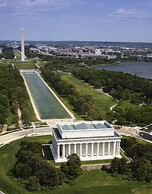
Washington, D.C., formally the District of Columbia and commonly called Washington or D.C., is the capital city and federal district of the United States. The city is on the Potomac River, across from Virginia, and shares land borders with Maryland to its north and east. Washington, D.C., was named for George Washington, a Founding Father and the first president of the United States. The district is named for Columbia, the female personification of the nation. (Full article...)

.jpg)

.jpeg)


Featured pictures


Main articles
 Categories
Associated Wikimedia
The following Wikimedia Foundation sister projects provide more on this subject:
-
 Commons
Free media repository -
 Wikibooks
Free textbooks and manuals -
 Wikidata
Free knowledge base -
 Wikinews
Free-content news -
 Wikiquote
Collection of quotations -
 Wikisource
Free-content library -
 Wikiversity
Free learning tools -
 Wikivoyage
Free travel guide -
 Wiktionary
Dictionary and thesaurus


