Fitxer:Outre-mer_en.png
From Wikipedia, the free encyclopedia
Mida d'aquesta previsualització: 800 × 400 píxels. Altres resolucions: 320 × 160 píxels | 640 × 320 píxels | 1.480 × 740 píxels.
Fitxer original (1.480 × 740 píxels, mida del fitxer: 54 Ko, tipus MIME: image/png)
| Aquest fitxer i la informació mostrada a continuació provenen del dipòsit multimèdia lliure Wikimedia Commons. |
Resum
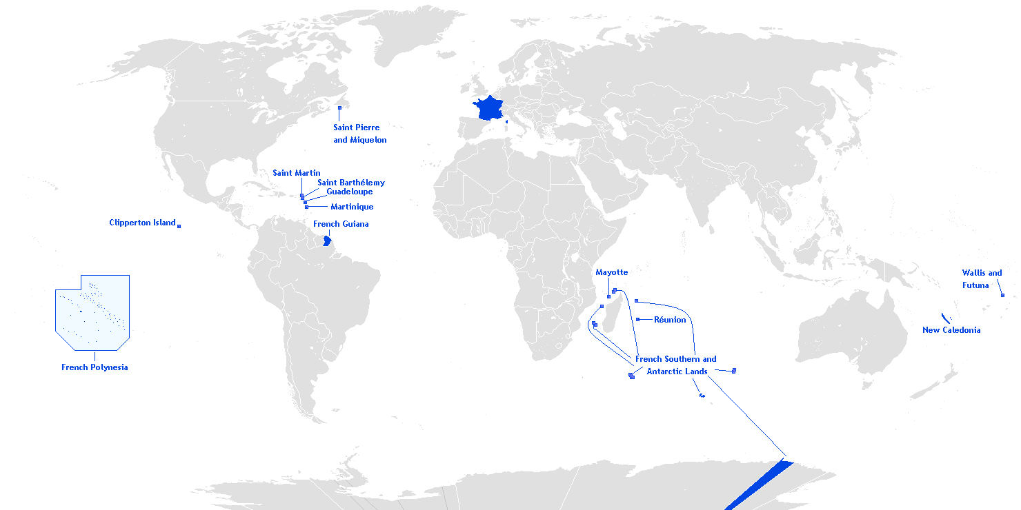
English: This is a translation from esperanto (by Hoshie) into english of User:Manchot sanguinaire's map of French Overseas départements, regions, collectivités, and territories, which is at Image:Outre-mer eo.png. The translations of the names into english are the names used in the CIA World Factbook. I also also added the five Îles Éparses that surround Madagascar. The source for their placement on the map is the CIA Factbook map of the area, which is here on Commons at Image:Iles Eparses-CIA WFB Map.png. The placement of Adélie Land is based upon Image:Antarctica territorial claims.png by User:Astrokey44. Since the original map is GFDL, this one is too.

|
Aquesta imatge (de tipus locator map) s'hauria de tornar a crear utilitzant gràfics vectorials com ara un fitxer SVG. Això té diversos avantatges; en trobareu més informació a Commons:Media for cleanup. Si ja disposeu d'una versió d'aquesta imatge en format SVG, us preguem que la pengeu; després, reemplaceu aquesta plantilla amb la plantilla {{Vector version available|nom nou de la imatge.svg}} en aquesta imatge.
|
Llicència
Hoshie, el titular dels drets d'autor d'aquest treball, el public sota la següent llicència:

|
S'autoritza la còpia, la distribució i la modificació d'aquest document sota els termes de la llicència de documentació lliure GNU versió 1.2 o qualsevol altra versió posterior que publiqui la Free Software Foundation; sense seccions invariants, ni textos de portada, ni textos de contraportada. S'inclou una còpia d'aquesta llicència en la secció titulada GNU Free Documentation License.http://www.gnu.org/copyleft/fdl.htmlGFDLGNU Free Documentation Licensetruetrue |
| Aquest fitxer està subjecte a la llicència de Creative Commons Reconeixement i Compartir Igual 3.0 No adaptada. | ||
| Reconeixement: Hoshie | ||
| ||
| Aquest avís de llicència s'ha afegit a aquest fitxer d'acord amb l'actualització de la llicència GFDL.http://creativecommons.org/licenses/by-sa/3.0/CC BY-SA 3.0Creative Commons Attribution-Share Alike 3.0truetrue |
Llegendes
Afegeix una explicació d'una línia del que representa aquest fitxer
Map of France's overseas possessions as of 2020
Fransız deniz aşırı toprakları
Elements representats en aquest fitxer
representa l'entitat
Historial del fitxer
Cliqueu una data/hora per veure el fitxer tal com era aleshores.
(les més noves | les més antigues) Mostra (10 posteriors | 10 anteriors) (10 | 20 | 50 | 100 | 250 | 500)
| Data/hora | Miniatura | Dimensions | Usuari/a | Comentari | |
|---|---|---|---|---|---|
| actual | 22:27, 27 març 2018 | | 1.480 × 740 (54 Ko) | Maphobbyist | Upload |
| 11:12, 28 feb 2016 |  | 1.480 × 740 (54 Ko) | Kontrollstellekundl | Polynesia colour | |
| 15:15, 24 jul 2013 |  | 1.480 × 740 (44 Ko) | DrKay | remove dark grey areas in Antartica, Dniestr, Kosovo, Palestine, etc. | |
| 22:41, 12 feb 2012 |  | 1.480 × 740 (75 Ko) | Spesh531 | +south sudan, antarctic territories, other lands, change color of land, fixed boudaries, added accents on e in R e union and Saint Barth e lemy, fixed islands in French Polynesia | |
| 05:12, 17 des 2007 |  | 1.432 × 742 (58 Ko) | Rosss | More accurate shape for French Polynesia | |
| 04:44, 22 abr 2007 |  | 1.432 × 742 (39 Ko) | Kelvinc | fixed shading of antarctica east of adelie land | |
| 11:59, 17 abr 2007 |  | 1.432 × 742 (26 Ko) | Tene~commonswiki | Optimised (0) | |
| 16:14, 5 març 2007 |  | 1.432 × 742 (60 Ko) | Hoshie | added Antarctica itself to the image and marked the French claim. The position of St.-Barth and St.-Martin has been fixed | |
| 20:26, 4 març 2007 |  | 1.357 × 628 (53 Ko) | Hoshie | removed labels for the Iles Eparses, since they are a part of the TAAF; see http://www.taaf.fr/rubriques/iles/iles_introduction.htm | |
| 09:11, 2 març 2007 |  | 1.357 × 628 (54 Ko) | Hoshie | fixed map to include St.-Martin and St.-Barth. |
(les més noves | les més antigues) Mostra (10 posteriors | 10 anteriors) (10 | 20 | 50 | 100 | 250 | 500)
Ús del fitxer
Les 3 pàgines següents utilitzen aquest fitxer:
Ús global del fitxer
Utilització d'aquest fitxer en altres wikis:
- Utilització a af.wikipedia.org
- Utilització a ar.wikipedia.org
- Utilització a as.wikipedia.org
- Utilització a az.wikipedia.org
- Utilització a bcl.wikipedia.org
- Utilització a be.wikipedia.org
- Utilització a da.wikipedia.org
- Utilització a de.wikipedia.org
- Utilització a el.wikipedia.org
- Utilització a en.wikipedia.org
- Portal:France/Geography
- Portal:France/Administrative divisions
- Template:Infobox European Parliament constituency
- Overseas Territories of France (European Parliament constituency)
- Template:Infobox European Parliament constituency/doc
- Overseas France
- Template:Infobox European Parliament constituency/sandbox
- Utilització a eo.wikipedia.org
- Utilització a es.wikipedia.org
- Utilització a et.wikipedia.org
- Utilització a eu.wikipedia.org
Vegeu més usos globals d'aquest fitxer.
Metadades
Aquest fitxer conté informació addicional, probablement afegida per la càmera digital o l'escàner utilitzat per a crear-lo o digitalitzar-lo. Si s'ha modificat posteriorment, alguns detalls poden no reflectir les dades reals del fitxer modificat.
| Resolució horitzontal | 37,8 ppc |
|---|---|
| Resolució vertical | 37,8 ppc |
Obtingut de «https://ca.wikipedia.org/wiki/Fitxer:Outre-mer_en.png»