Argyll and Bute
Unitary Authority in Schottland Aus Wikipedia, der freien Enzyklopädie
Unitary Authority in Schottland Aus Wikipedia, der freien Enzyklopädie
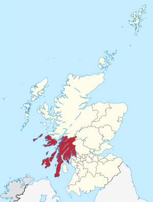
Argyll and Bute (gälisch: Earra-Ghàidheal agus Bòd) ist eine von 32 Council Areas in Schottland. Sie grenzt an Highland, Perth and Kinross, Stirling und West Dunbartonshire. Die östliche Grenze verläuft durch den Loch Lomond. Der Verwaltungssitz ist in Lochgilphead.
| Argyll and Bute Earra-Ghàidheal agus Bòd | |
|---|---|
 | |
| Verwaltungssitz | Lochgilphead |
| Fläche | 6.909 km² (2.) |
| Einwohner | 88.166[1] (26.) |
| ISO 3166-2 | GB-AGB |
| ONS-Code | 00QD |
| Website | www.argyll-bute.gov.uk |
Der größte Teil des Verwaltungsbezirks gehörte einst zur traditionellen Grafschaft Argyll, mit Ausnahme der Region Morvern nördlich von Mull, das heute zu Highland gehört. Der Bezirk umfasst auch die im Firth of Clyde liegende Isle of Bute, die zur traditionellen Grafschaft Bute gehörte sowie den westlichen Teil der traditionellen Grafschaft Dunbartonshire.
Seit den Lokalwahlen 2017 setzt sich der 36 Sitze umfassende Council von Argyll and Bute wie folgt zusammen:[2]
| Partei | Sitze |
|---|---|
| Scottish National Party | 11 |
| Unabhängig | 10 |
| Liberal Democrats | 9 |
| Scottish Conservatives | 6 |
Seit 1967 besteht eine Partnerschaft mit dem Landkreis Amberg-Sulzbach in Bayern.
Seamless Wikipedia browsing. On steroids.
Every time you click a link to Wikipedia, Wiktionary or Wikiquote in your browser's search results, it will show the modern Wikiwand interface.
Wikiwand extension is a five stars, simple, with minimum permission required to keep your browsing private, safe and transparent.
