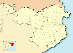
Cantallops
Municipality in Catalonia, Spain From Wikipedia, the free encyclopedia
Cantallops is a municipality in the comarca of the Alt Empordà in Girona, Catalonia, Spain. It is situated below the Albera Range, and is linked to La Jonquera by the GI-601 road.
Cantallops | |
|---|---|
 Entrance to the village | |
| Coordinates: 42°25′28″N 2°55′34″E | |
| Country | |
| Community | |
| Province | Girona |
| Comarca | Alt Empordà |
| Government | |
| • Mayor | Joan Sabartés Olivet (2015)[1] |
| Area | |
| • Total | 19.6 km2 (7.6 sq mi) |
| Elevation | 200 m (700 ft) |
| Population (2018)[3] | |
| • Total | 313 |
| • Density | 16/km2 (41/sq mi) |
| Demonym(s) | Cantallobenc, cantallobenca |
| Website | www |
The town originated around the ancient Cantallops castle, documented since the 13th century. Currently, only partial remains remain, a fragment of the wall and a single tower that, in the 19th century, was converted into a bell tower of the parochial church of Sant Esteve.[4]
Demography
| 1900 | 1930 | 1950 | 1970 | 1986 | 2007 |
|---|---|---|---|---|---|
| 731 | 571 | 461 | 414 | 259 | 295 |
References
External links
Wikiwand in your browser!
Seamless Wikipedia browsing. On steroids.
Every time you click a link to Wikipedia, Wiktionary or Wikiquote in your browser's search results, it will show the modern Wikiwand interface.
Wikiwand extension is a five stars, simple, with minimum permission required to keep your browsing private, safe and transparent.


