File:ICE_Network.png
De Wikipedia, l'encyclopédie encyclopedia
Taille de cet aperçu : 444 × 599 pixels. Autres résolutions : 178 × 240 pixels | 355 × 480 pixels | 569 × 768 pixels | 1 200 × 1 620 pixels.
Fichier d’origine (1 200 × 1 620 pixels, taille du fichier : 582 kio, type MIME : image/png)
Ce fichier et sa description proviennent de Wikimedia Commons.

|
Cette image (de type transport map) devrait être recréée dans un format vectoriel, en tant que fichier SVG. Cela offrirait plusieurs avantages : voir Commons:Media for cleanup pour plus d'informations. Si une version SVG de cette image est déjà disponible, merci de bien vouloir l'envoyer. Après cela, remplacez ce modèle par {{vector version available|nouveau nom d'image.svg}}.
|
Description
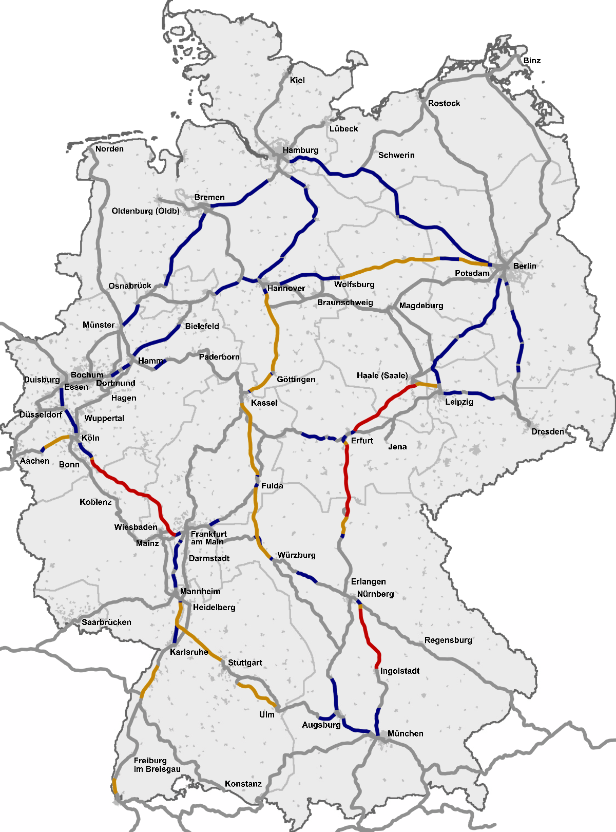
Deutsch (de): Deutsches ICE-Netz
English (en): The InterCityExpress (ICE) network in Germany
Esperanto (eo): Reto de ICE en Germanio
español (es): Red InterCityExpress (ICE) en Alemania
italiano (it): La rete degli InterCityExpress (ICE) in Germania
français (fr): Réseau ICE allemand
Nederlands (nl): Duitse ICE-net
slovenčina (sk): Sieť ICE vlakov v Nemeckej spolkovej republike
polski (pl): Sieć pociągów ICE w Niemczech
čeština (cs): Síť vysokorychlostních vlaků ICE v Německu
română (ro): Reteaua InterCityExpress (ICE) in Germania
한국어 (ko): 독일 ICE 선로망 최고속도 표
suomi (fi): InterCityExpress (ICE) -verkko Saksassa
русский (ru): Сеть железнодорожных путей InterCityExpress (ICE) в Германии
中文 (zh): 城际特快列车 InterCityExpress (ICE) 在德国的铁路网
українська (uk): Мережа залізничних колій InterCityExpress (ICE) у Німеччині
Ελληνικά (el): Το σιδηροδρομικό δίκτυο της υπερταχείας InterCityExpress (ICE) στην Γερμανία
Source
Based on a map from OpenGeoDB, data from DB timetables, OpenRailwayMap and a map from ice-fanpage.de and DB releases like this.
Voir aussi
Voir aussi 
|
Conditions d’utilisation
This image was generated with OpenGeoDB. The information there is placed in the public domain, images generated from OpenGeoDB are derivative works without passing the threshold of creativity, they are therefore also public domain.
| Public domainPublic domainfalsefalse |
| Ce document n'est pas soumis au droit d'auteur et est donc dans le domaine public, car il est composé exclusivement d'informations qui sont dans le domaine public et ne contient aucune modification qui en ferait une œuvre originale. |
Légendes
Réseau InterCityExpress (ICE) allemand
The InterCityExpress (ICE) network map in Germany
ICE-Streckennetz mit Geschwindigkeitsangaben (Stand 2023)
Red InterCityExpress (ICE) en Alemania
image/png
Historique du fichier
Cliquer sur une date et heure pour voir le fichier tel qu'il était à ce moment-là.
(les plus récentes | les plus anciennes) Voir (10 plus récentes | 10 plus anciennes) (10 | 20 | 50 | 100 | 250 | 500)
| Date et heure | Vignette | Dimensions | Utilisateur | Commentaire | |
|---|---|---|---|---|---|
| actuel | 29 décembre 2022 à 11:18 | | 1 200 × 1 620 (582 kio) | DerBaomeister | Addition of line between Osnabrück and Löhne |
| 29 décembre 2022 à 10:48 |  | 1 200 × 1 620 (582 kio) | DerBaomeister | Addition of line between Berlin and Rostock | |
| 29 décembre 2022 à 04:15 |  | 1 200 × 1 620 (579 kio) | DerBaomeister | Addition of two lines and Potsdam | |
| 29 décembre 2022 à 02:59 |  | 1 200 × 1 620 (578 kio) | DerBaomeister | Second general revision of map with addition of new high-speed line between Wendlingen and Ulm | |
| 1 novembre 2022 à 04:37 |  | 1 200 × 1 620 (589 kio) | DerBaomeister | Small addition of stop in Coburg | |
| 27 octobre 2022 à 14:40 |  | 1 200 × 1 620 (589 kio) | DerBaomeister | Minor corrections | |
| 18 octobre 2022 à 22:19 |  | 1 200 × 1 620 (589 kio) | DerBaomeister | Improvements around Stuttgart; removal of one line | |
| 10 octobre 2022 à 02:17 |  | 1 200 × 1 620 (590 kio) | DerBaomeister | Some improvements | |
| 27 août 2022 à 18:16 |  | 1 200 × 1 620 (592 kio) | DerBaomeister | Further extension of international ICE/ECE lines | |
| 13 août 2022 à 19:34 |  | 1 200 × 1 620 (582 kio) | DerBaomeister | Extension of international ICE lines |
(les plus récentes | les plus anciennes) Voir (10 plus récentes | 10 plus anciennes) (10 | 20 | 50 | 100 | 250 | 500)
Utilisation du fichier
La page suivante utilise ce fichier :
Usage global du fichier
Les autres wikis suivants utilisent ce fichier :
- Utilisation sur bar.wikipedia.org
- Utilisation sur ca.wikipedia.org
- Utilisation sur cs.wikipedia.org
- Utilisation sur da.wikipedia.org
- Utilisation sur de.wikipedia.org
- Utilisation sur el.wikipedia.org
- Utilisation sur en.wikipedia.org
- Utilisation sur es.wikipedia.org
- Utilisation sur fi.wikipedia.org
- Utilisation sur fy.wikipedia.org
- Utilisation sur hu.wikipedia.org
- Utilisation sur it.wikipedia.org
- Utilisation sur ja.wikipedia.org
- Utilisation sur ko.wikipedia.org
- Utilisation sur lad.wikipedia.org
- Utilisation sur lb.wikipedia.org
- Utilisation sur ms.wikipedia.org
- Utilisation sur nl.wikipedia.org
- Utilisation sur nn.wikipedia.org
- Utilisation sur no.wikipedia.org
- Utilisation sur pl.wikipedia.org
- Utilisation sur ro.wikipedia.org
- Utilisation sur ru.wikipedia.org
- Utilisation sur sh.wikipedia.org
- Utilisation sur simple.wikipedia.org
- Utilisation sur sk.wikipedia.org
- Utilisation sur sr.wikipedia.org
- Utilisation sur uk.wikipedia.org
- Utilisation sur zh.wikipedia.org
Ce document provient de « https://fr.wikipedia.org/wiki/Fichier:ICE_Network.png ».