Bestand:India_railways1909a.jpg
Uit Wikipedia, de vrije encyclopedia
Oorspronkelijk bestand (1.322 × 1.103 pixels, bestandsgrootte: 336 kB, MIME-type: image/jpeg)
| Dit is een bestand van Wikimedia Commons. Onderstaande beschrijving komt van de beschrijving van het bestand daar. |
Beschrijving
| BeschrijvingIndia railways1909a.jpg |
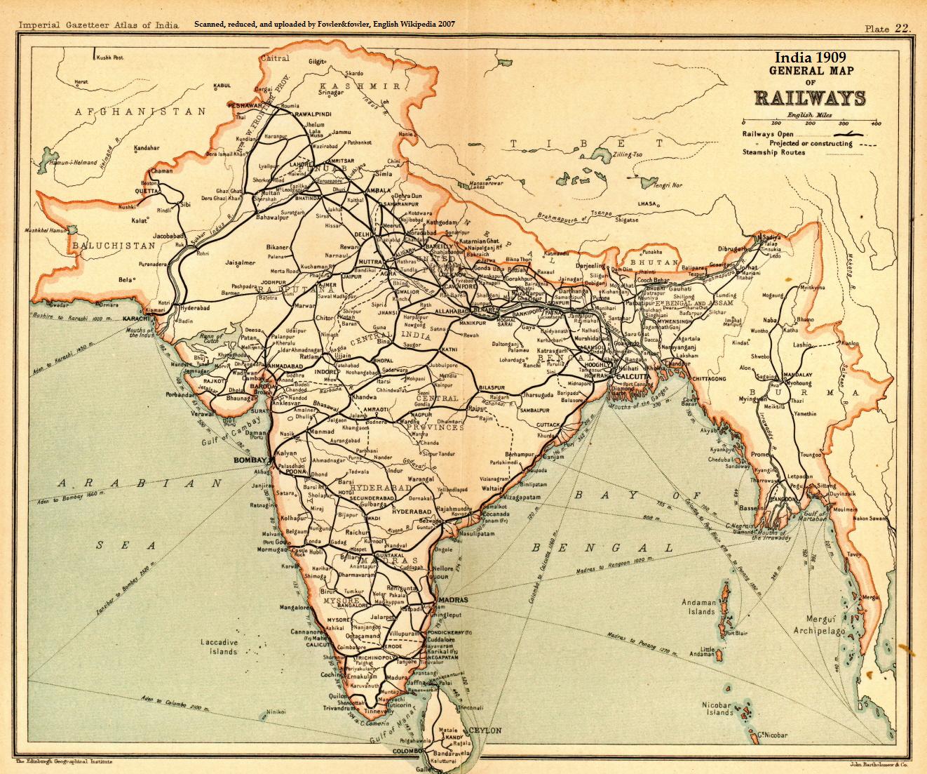
English: A general map of Indian railways, 1909. Scanned and reduced from personal copy of Imperial Gazetteer of India, volume 25
(Atlas), Oxford University Press, 1909, by Fowler&fowler«Talk» 05:05, 18 September 2007 (UTC) |
|||||||||
| Datum | ||||||||||
| Bron | Imperial Gazetteer of India, 1909 | |||||||||
| Maker |
John Bartholomew and Company/Edinburgh Geographical Institute |
|||||||||
| Geotemporal data | ||||||||||
| Bounding box |
|
|||||||||
| Georeferencing | View the georeferenced map in the Wikimaps Warper | |||||||||
Licentie
| Public domainPublic domainfalsefalse |
Dit artistieke werk gecreëerd door de Britse regering bevindt zich in het publiek domein.
Dit is vanwege een van de volgende redenen:
HMSO heeft verklaard dat het vervallen van Crown Copyrights wereldwijd van toepassing is (ref: HMSO Email Reply) Deutsch ∙ English ∙ Español ∙ français ∙ italiano ∙ Nederlands ∙ polski ∙ português ∙ sicilianu ∙ slovenščina ∙ suomi ∙ Türkçe ∙ македонски ∙ русский ∙ українська ∙ മലയാളം ∙ 한국어 ∙ 日本語 ∙ 简体中文 ∙ 繁體中文 ∙ العربية ∙ +/− |
 |
Oorspronkelijk uploadlogboek
- 2007-09-18 05:05 Fowler&fowler 1322×1103× (344309 bytes) Scanned and reduced from personal copy of Imperial Gazetteer of India, volume 25 (Atlas), Oxford University Press, 1909, by ~~~~ {{PD-US-1923-abroad}}
Bestandsgeschiedenis
Klik op een datum/tijd om het bestand te zien zoals het destijds was.
| Datum/tijd | Miniatuur | Afmetingen | Gebruiker | Opmerking | |
|---|---|---|---|---|---|
| huidige versie | 24 okt 2010 19:32 | | 1.322 × 1.103 (336 kB) | File Upload Bot (Magnus Manske) | {{BotMoveToCommons|en.wikipedia|year={{subst:CURRENTYEAR}}|month={{subst:CURRENTMONTHNAME}}|day={{subst:CURRENTDAY}}}} {{Information |Description={{en|Scanned and reduced from personal copy of Imperial Gazetteer of India, volume 25 (Atlas), Oxford Unive |
Bestandsgebruik
Dit bestand wordt op de volgende pagina gebruikt:
Globaal bestandsgebruik
De volgende andere wiki's gebruiken dit bestand:
- Gebruikt op ar.wikipedia.org
- Gebruikt op ast.wikipedia.org
- Gebruikt op as.wikipedia.org
- Gebruikt op bn.wikipedia.org
- Gebruikt op ca.wikipedia.org
- Gebruikt op de.wikipedia.org
- Gebruikt op en.wikipedia.org
- Rail transport in India
- History of rail transport
- Indian Railways
- North Western Railway zone
- History of science and technology on the Indian subcontinent
- Economic history of India
- Northern Railway zone
- North Central Railway zone
- North Eastern Railway zone
- Kathgodam
- Thar Express
- British Raj
- User:Fowler&fowler
- User:Fowler&fowler/Short History Indian Independence Movement
- Economy of India under the British Raj
- History of the British Raj
- User talk:Nichalp/Archive66
- Portal:Trains/Did you know/February 2009
- History of Bareilly
- Economic history of Pakistan
- Indian reunification
- Talk:British Raj/Archive 8
- Palwal railway station
- Rail transport in Haryana
- User:Feroze Ahmad 2/sandbox4
- User:AustinJAragon/sandbox
- User:Frank.p873/sandbox
- User:Efrain805/British Raj
- User:AustinJAragon/British Raj railway section
- User:Falcaorib/India and Pakistan
- Gebruikt op es.wikipedia.org
Globaal gebruik van dit bestand bekijken.
Metadata
Dit bestand bevat metadata met EXIF-informatie, die door een fotocamera, scanner of fotobewerkingsprogramma toegevoegd kan zijn.
| Omschrijving afbeelding | LEAD Technologies Inc. V1.01 |
|---|---|
| Horizontale resolutie | 300 dpi |
| Verticale resolutie | 300 dpi |
| Y- en C-positionering | Gecositueerd |
| Exif-versie | 2.2 |
| Kleurruimte | sRGB |