படிமம்:Pre_Historic_Mid_Krishna-Tungabhadra_Valley_sites.jpg
From Wikipedia, the free encyclopedia
இந்த முன்னோட்டத்தின் அளவு: 726 × 600 படப்புள்ளிகள் . மற்ற பிரிதிறன்கள்: 291 × 240 படப்புள்ளிகள் | 581 × 480 படப்புள்ளிகள் | 929 × 768 படப்புள்ளிகள் | 1,239 × 1,024 படப்புள்ளிகள் | 2,338 × 1,932 படப்புள்ளிகள் .
மூலக்கோப்பு (2,338 × 1,932 படவணுக்கள், கோப்பின் அளவு: 876 KB, MIME வகை: image/jpeg)
| இது விக்கிமீடியா பொதுக்கோப்பகத்தில் இருக்கும் ஒரு கோப்பாகும். இக்கோப்பைக் குறித்து அங்கே காணப்படும் படிம விளக்கப் பக்கத்தை இங்கே கீழே காணலாம்.
|

|
This historical map image could be re-created using vector graphics as an SVG file. This has several advantages; see Commons:Media for cleanup for more information. If an SVG form of this image is available, please upload it and afterwards replace this template with
{{vector version available|new image name}}.
It is recommended to name the SVG file “Pre Historic Mid Krishna-Tungabhadra Valley sites.svg”—then the template Vector version available (or Vva) does not need the new image name parameter. |
 | This historical map image was uploaded in the JPEG format even though it consists of non-photographic data. This information could be stored more efficiently or accurately in the PNG or SVG format. If possible, please upload a PNG or SVG version of this image without compression artifacts, derived from a non-JPEG source (or with existing artifacts removed). After doing so, please tag the JPEG version with {{Superseded|NewImage.ext}} and remove this tag. This tag should not be applied to photographs or scans. If this image is a diagram or other image suitable for vectorisation, please tag this image with {{Convert to SVG}} instead of {{BadJPEG}}. If not suitable for vectorisation, use {{Convert to PNG}}. For more information, see {{BadJPEG}}. |  |
சுருக்கம்
| விளக்கம்Pre Historic Mid Krishna-Tungabhadra Valley sites.jpg |
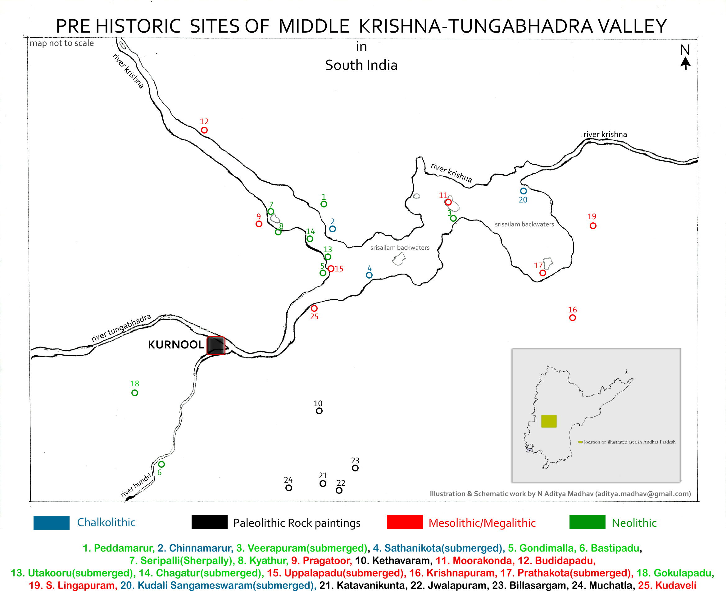
English: Pre Historic Mid Krishna-Tungabhadra Valley sites are:
1. Peddamarur, 2. Chinnamarur, 3. Veerapuram(submerged), 4. Sathanikota(submerged), 5. Gondimalla, 6. Bastipadu, 7. Seripalli(Sherpally), 8. Kyathur, 9. Pragatoor, 10. Kethavaram, 11. Moorakonda, 12. Budidapadu, 13. Utakooru(submerged), 14. Chagatur(submerged), 15. Uppalapadu(submerged), 16. Krishnapuram, 17. Prathakota(submerged), 18. Gokulapadu, 19. S. Lingapuram, 20. Kudali Sangameswaram(submerged), 21. Katavanikunta, 22. Jwalapuram, 23. Billasargam, 24. Muchatla, 25. Kudaveli Note: The map is created for information and educational purposes. People using the map outside Wikipedia projects are requested to attribute it properly. |
| நாள் | |
| மூலம் | சொந்த முயற்சி |
| ஆசிரியர் | Adityamadhav83 |
Data collected from Department of Archaeology and Museums, Hyderabad, Andhra Pradesh and Journals on Proto Historic culture and settlements in Andhra Pradesh.
அனுமதி
இந்த ஆக்கத்தின் காப்புரிமையாளரான நான் இதனைப் பின்வரும் உரிமத்தின் கீழ் வெளியிடுகின்றேன்:
இந்த கோப்பு Creative Commons Attribution-Share Alike 3.0 Unported உரிமத்தின் கீழ் உள்ளது.
- நீங்கள் சுதந்திரமாக:
- பகிர்ந்து கொள்ள – வேலையை நகலெடுக்க, விநியோகிக்க மற்றும் அனுப்ப
- மீண்டும் கலக்க – வேலைக்கு பழகிக்கொள்ள.
- கீழ்க்காணும் விதிகளுக்கு ஏற்ப,
- பண்புக்கூறுகள் – நீங்கள் பொருத்தமான உரிமையை வழங்க வேண்டும், உரிமத்திற்கான இணைப்பை வழங்க வேண்டும் மற்றும் மாற்றங்கள் செய்யப்பட்டிருந்தால் குறிப்பிட வேண்டும். நீங்கள் ஏற்புடைய எந்த முறையிலும் அவ்வாறு செய்யலாம், ஆனால் எந்த வகையிலும் உரிமதாரர் உங்களை அல்லது உங்கள் பயன்பாட்டிற்கு ஒப்புதல் அளிக்கும் படி பரிந்துரைக்க கூடாது.
- அதே மாதிரி பகிர் – நீங்கள் ரீமிக்ஸ் செய்தாலோ, உருமாற்றம் செய்தாலோ அல்லது பொருளை உருவாக்கினாலோ, உங்கள் பங்களிப்புகளை அல்லது இணக்கமான உரிமம் கீழ் அசலாக விநியோகிக்க வேண்டும்.
Captions
Add a one-line explanation of what this file represents
Items portrayed in this file
சித்தரிப்பில் உள்ளது
some value
copyright status ஆங்கிலம்
copyrighted ஆங்கிலம்
27 ஏப்பிரல் 2013
source of file ஆங்கிலம்
original creation by uploader ஆங்கிலம்
கோப்பின் வரலாறு
குறித்த நேரத்தில் இருந்த படிமத்தைப் பார்க்க அந்நேரத்தின் மீது சொடுக்கவும்.
| நாள்/நேரம் | நகம் அளவு சிறுபடம் | அளவுகள் | பயனர் | கருத்து | |
|---|---|---|---|---|---|
| தற்போதைய | 06:55, 10 மே 2013 | | 2,338 × 1,932 (876 KB) | Adityamadhav83 | Location in Andhra Pradesh state included in the illustration |
| 19:31, 26 ஏப்பிரல் 2013 |  | 2,338 × 1,932 (848 KB) | Adityamadhav83 | User created page with UploadWizard |
கோப்பு பயன்பாடு
பின்வரும் 3 பக்கங்கள் இணைப்பு இப் படிமத்துக்கு இணைக்கபட்டுள்ளது(ளன):
கோப்பின் முழுமையான பயன்பாடு
கீழ்கண்ட மற்ற விக்கிகள் இந்த கோப்பை பயன்படுத்துகின்றன:
- ar.wikipedia.org-திட்டத்தில் இதன் பயன்பாடு
- bn.wikipedia.org-திட்டத்தில் இதன் பயன்பாடு
- ca.wikipedia.org-திட்டத்தில் இதன் பயன்பாடு
- de.wikipedia.org-திட்டத்தில் இதன் பயன்பாடு
- en.wikipedia.org-திட்டத்தில் இதன் பயன்பாடு
- es.wikipedia.org-திட்டத்தில் இதன் பயன்பாடு
- fr.wikipedia.org-திட்டத்தில் இதன் பயன்பாடு
- kn.wikipedia.org-திட்டத்தில் இதன் பயன்பாடு
- mr.wikipedia.org-திட்டத்தில் இதன் பயன்பாடு
- pa.wikipedia.org-திட்டத்தில் இதன் பயன்பாடு
- pnb.wikipedia.org-திட்டத்தில் இதன் பயன்பாடு
- si.wikipedia.org-திட்டத்தில் இதன் பயன்பாடு
- sr.wikipedia.org-திட்டத்தில் இதன் பயன்பாடு
- te.wikipedia.org-திட்டத்தில் இதன் பயன்பாடு
- tr.wikipedia.org-திட்டத்தில் இதன் பயன்பாடு
- ur.wikipedia.org-திட்டத்தில் இதன் பயன்பாடு
- zh.wikipedia.org-திட்டத்தில் இதன் பயன்பாடு
மேனிலைத் தரவு
இந்தக் கோப்பு கூடுதலான தகவல்களைக் கொண்டுளது, இவை பெரும்பாலும் இக்கோப்பை உருவாக்கப் பயன்படுத்திய எண்ணிம ஒளிப்படக்கருவி அல்லது ஒளிவருடியால் சேர்க்கப்பட்டிருக்கலாம். இக்கோப்பு ஏதாவது வகையில் மாற்றியமைக்கப்பட்டிருந்தால் இத்தகவல்கள் அவற்றைச் சரிவர தராமல் இருக்கலாம்.
| திசை | வழமையான |
|---|---|
| கிடை நுணுக்கம் | 200 dpi |
| நிலைக்குத்து நுணுக்கம் | 200 dpi |
| பயன்படுத்தப்பட்ட மென்பொருள் | Adobe Photoshop 7.0 |
| கோப்பு மாற்ற நாள் நேரம் | 12:20, 10 மே 2013 |
| நிற வெளி | அளவு திருத்தப்படாதது |
"https://ta.wikipedia.org/wiki/படிமம்:Pre_Historic_Mid_Krishna-Tungabhadra_Valley_sites.jpg" இலிருந்து மீள்விக்கப்பட்டது