File:Plan_Odendaal.png
维基百科,自由的 encyclopedia
此为最大尺寸。
Plan_Odendaal.png (418 × 418像素,文件大小:33 KB,MIME类型:image/png)

|
此map图片可使用矢量图形重新创建为SVG文件。这具有很多好处;更多信息请参见共享资源:待清理媒体。如果存在此图片的SVG格式,请将其上传,然后将此模板替换为
{{vector version available|新图片名称}}。
建议您将SVG命名为“Plan Odendaal.svg”,这样在使用Vector version available(或Vva)模板时就不需要填写新图片名称参数。 |
摘要
| 描述Plan Odendaal.png |
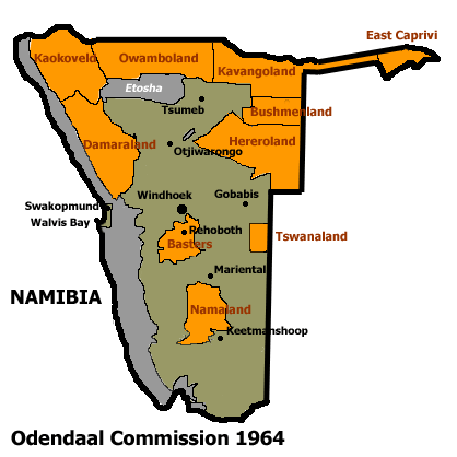
Español: Bantustanes en el territorio de Namibia con Damaraland al noroeste del país
English: This map shows the Odendaal Commission Plan for Namibia of 1964. The plan divided Namibia into Bantustans or Homelands. |
||||||||
| 日期 | |||||||||
| 来源 |
本文件缺少来源信息。
请编辑本文件的说明并提供来源。 |
||||||||
| 作者 | Bries | ||||||||
| 授权 (二次使用本文件) |
|
||||||||
| 其他版本 | French version : Image:Plan_Odendaal-fr.png |

说明
添加一行文字以描述该文件所表现的内容
此文件中描述的项目
描绘内容
GNU自由文档许可证1.2或更高版本 简体中文(已转写)
知识共享署名-相同方式共享3.0未本地化版本 简体中文(已转写)
21 4 2005
文件历史
点击某个日期/时间查看对应时刻的文件。
| 日期/时间 | 缩略图 | 大小 | 用户 | 备注 | |
|---|---|---|---|---|---|
| 当前 | 2023年11月25日 (六) 22:00 | | 418 × 418(33 KB) | LoomCreek | Transparency |
| 2005年4月21日 (四) 07:40 |  | 418 × 418(15 KB) | Bries | This map shows the Odendaal Commission Plan for Namibia of 1964. The plan divided Namibia into ''Bantustans'' or ''Homelands''. I have created the map for the Wikipedia community. Category:Maps of Namibia {{GFDL}} |
文件用途
全域文件用途
以下其他wiki使用此文件:
- af.wikipedia.org上的用途
- ar.wikipedia.org上的用途
- ast.wikipedia.org上的用途
- bn.wikipedia.org上的用途
- ca.wikipedia.org上的用途
- Bantustan
- Hereros
- Resolució 301 del Consell de Seguretat de les Nacions Unides
- Resolució 309 del Consell de Seguretat de les Nacions Unides
- Resolució 310 del Consell de Seguretat de les Nacions Unides
- Resolució 319 del Consell de Seguretat de les Nacions Unides
- Resolució 323 del Consell de Seguretat de les Nacions Unides
- Resolució 342 del Consell de Seguretat de les Nacions Unides
- Resolució 366 del Consell de Seguretat de les Nacions Unides
- ckb.wikipedia.org上的用途
- de.wikipedia.org上的用途
- en.wikipedia.org上的用途
- South West Africa
- History of Namibia
- Bantustan
- Kaokoland
- Bushmanland (South West Africa)
- Hereroland
- Ovamboland
- Damaraland
- Tswanaland
- Kavangoland
- Rehoboth (homeland)
- Namaland
- East Caprivi
- Fox Odendaal
- Diocese of Namibia
- United Nations Security Council Resolution 301
- Land reform in Namibia
- Aminuis
- Constance Kgosiemang
- es.wikipedia.org上的用途
查看此文件的更多全域用途。
元数据
此文件中包含有扩展的信息。这些信息可能是由数码相机或扫描仪在创建或数字化过程中所添加。
如果此文件的源文件已经被修改,一些信息在修改后的文件中将不能完全反映出来。
| 使用软件 | Adobe Photoshop 22.5 (Windows) |
|---|---|
| 数字化日期时间 | 2023年11月25日 (六) 11:29 |
| 文件修改日期时间 | 2023年11月25日 (六) 11:50 |
| 原始数据最后修改日期 | 2023年11月25日 (六) 11:50 |
| 原始文件唯一ID | xmp.did:7c8f4e4e-7830-374b-b711-2ab639de85e8 |
| 水平分辨率 | 28.35 dpc |
| 垂直分辨率 | 28.35 dpc |