File:Aerial_view_of_the_Central_Intelligence_Agency_headquarters,_Langley,_Virginia_-_Corrected.tif
維基百科,自由的 encyclopedia

此TIF文件的JPG预览的大小:769 × 600像素。 其他分辨率:308 × 240像素 | 615 × 480像素 | 984 × 768像素 | 1,280 × 999像素 | 2,560 × 1,997像素 | 6,133 × 4,785像素。
原始文件 (6,133 × 4,785像素,文件大小:140.71 MB,MIME类型:image/tiff)
摘要
| Aerial view of the Central Intelligence Agency headquarters, Langley, Virginia
( |
|||||||||||||||||||||||||||
|---|---|---|---|---|---|---|---|---|---|---|---|---|---|---|---|---|---|---|---|---|---|---|---|---|---|---|---|
| 作者 |
creator QS:P170,Q5044454 |
||||||||||||||||||||||||||
| 标题 |
Aerial view of the Central Intelligence Agency headquarters, Langley, Virginia |
||||||||||||||||||||||||||
| 描绘地点 | Central Intelligence Agency headquarters | ||||||||||||||||||||||||||
| 日期 | 在1980年到2006年之间 | ||||||||||||||||||||||||||
| 表现形式 | 1 transparency : color | ||||||||||||||||||||||||||
| 尺寸 | 4 x 5 in. or smaller. | ||||||||||||||||||||||||||
| 藏于 |
institution QS:P195,Q131454 |
||||||||||||||||||||||||||
| 现存地点 |
Prints and Photographs Division http://hdl.loc.gov/loc.pnp/pp.print |
||||||||||||||||||||||||||
| 备注 |
|
||||||||||||||||||||||||||
| 来源 |
|
||||||||||||||||||||||||||
| 授权 (二次使用本文件) |
Rights Advisory: No known restrictions on publication. | ||||||||||||||||||||||||||
| 其他版本 |
|
||||||||||||||||||||||||||


| 38° 57′ 18.43″ 北, 77° 08′ 24.34″ 西 | 在以下服务上查看本图像和附近其他图像: OpenStreetMap |
许可协议
| Public domainPublic domainfalsefalse |
| 本作品来自Library of Congress旗下的Carol M. Highsmith Archive收藏。根据图书馆说明,使用该作品没有已知版权限制。 Carol M. Highsmith has stipulated that her photographs are in the public domain. Photographs of sculpture or other works of art may be restricted by the copyright of the artist; see Commons:FOP US#Artworks and sculptures for more information. |
 |
说明
添加一行文字以描述该文件所表现的内容
此文件中描述的项目
描繪內容
38°57'18.43"N, 77°8'24.36"W
image/tiff
147,545,326 字节
4,785 像素
6,133 像素
1
文件历史
点击某个日期/时间查看对应时刻的文件。
| 日期/时间 | 缩略图 | 大小 | 用户 | 备注 | |
|---|---|---|---|---|---|
| 当前 | 2017年4月22日 (六) 18:13 | 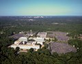 | 6,133 × 4,785(140.71 MB) | Falcorian | User created page with UploadWizard |
文件用途
没有页面链接到本图像。
元数据
此文件中包含有扩展的信息。这些信息可能是由数码相机或扫描仪在创建或数字化过程中所添加。
如果此文件的源文件已经被修改,一些信息在修改后的文件中将不能完全反映出来。
| 图像标题 | Aerial view of the Central Intelligence Agency headquarters. |
|---|---|
| 作者 | Photographer: Carol M. Highsmith |
| 纬度 | 38°57′18.43″N |
| 经度 | 77°8′24.34″W |
| 宽度 | 6,133 px |
| 高度 | 4,785 px |
| 每色彩组分位数 |
|
| 压缩方案 | Deflate(Adobe) |
| 像素构成 | RGB |
| 色彩组分数 | 3 |
| 每带行数 | 16 |
| 水平分辨率 | 240 dpi |
| 垂直分辨率 | 240 dpi |
| 数据排布 | 大块格式 |
| 使用软件 | Adobe Photoshop Lightroom 5.7.1 (Windows) |
| 文件修改日期时间 | 2017年4月22日 (六) 08:46 |
| Exif版本 | 2.3 |
| 数字化日期时间 | 2011年8月17日 (三) 15:55 |
| GPS标签版本 | 0.0.2.2 |