File:Baltic_Sea_Map-Masry.PNG
From Wikipedia, the free encyclopedia
Tamañu d'esta previsualización: 560 × 600 pixels. Otres resoluciones: 224 × 240 pixels | 448 × 480 pixels | 717 × 768 pixels | 956 × 1024 pixels | 1500 × 1606 pixels.
Ficheru orixinal (1500 × 1606 píxels, tamañu de ficheru: 663 kB, triba MIME: image/png)
Esti ficheru ye de Wikimedia Commons y puen usalu otros proyeutos. La descripción de la páxina de descripción del ficheru s'amuesa darréu.
| DescripciónBaltic Sea Map-Masry.PNG |
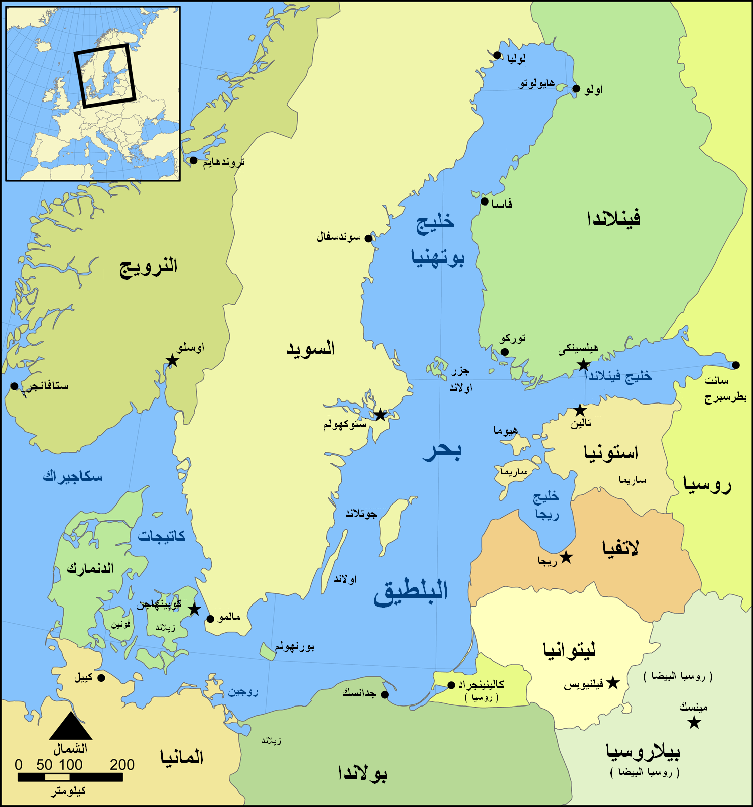
English: This is a map of the Baltic Sea, Arabic/Masry version |
| Data | |
| Fonte | Trabayu propiu (based on Baltic Sea map.png by NormanEinstein) |
| Autor | NormanEinstein (derivative work: Ramsis II) |
| Otres versiones |
[editar]
|


Yo, el titular de los drechos d'autor d'esta obra, la espublizo baxo la siguiente llicencia:

|
Autorízase la copia, distribución y/o cambéu d'esti documentu baxo los términos de la Llicencia de documentación llibre GNU, versión 1.2 o cualesquier otra que nel futuru espublice la Free Software Foundation; ensin seiciones invariables, testos de portada, nin testos de contraportada. S'inclúi una copia de la llicencia na seición titulada GNU Free Documentation License.http://www.gnu.org/copyleft/fdl.htmlGFDLGNU Free Documentation Licensetruetrue |
| Esti ficheru ta disponible baxo la llicencia Creative Commons Reconocimientu-Compartir igual 3.0 xenérica. | ||
| ||
| Esta etiqueta de llicencia s'amestó a esti ficheru como parte del anovamientu de la llicencia GFDL.http://creativecommons.org/licenses/by-sa/3.0/CC BY-SA 3.0Creative Commons Attribution-Share Alike 3.0truetrue |
| Esta ye una imaxe retocada, lo que significa que foi modificada dixitalmente de la so versión orixinal. Modificaciones: masry Translation. La orixinal pue vese equí: ArchipelagoSeaInBalticSea.png:
|
Rexistru de xubíes orixinal
This image is a derivative work of the following images:
- File:ArchipelagoSeaInBalticSea.png licensed with GFDL, GFDL
- 2008-08-14T10:17:42Z Suncheng125 1500x1606 (798387 Bytes) {{Information |Description=This is a map of the [[Baltic Sea]] with the [[Archipelago Sea]] marked. It is a slightly modified version of the file "Baltic Sea map.png". |Source=English Wikipedia |Date=August 8th, 2008 |Author=
Uploaded with derivativeFX
Pies
Añade una explicación corta acerca de lo que representa este archivo
Elementos representados en este archivo
representa a
Algún valor sin elemento de Wikidata
21 xnt 2009
tipo de archivo español
image/png
suma de verificación español
ba58174ac7973acad426b4e96c9a992667e85553
tamaño de los datos español
679 125 Byte
1606 píxel
1500 píxel
Historial del ficheru
Calca nuna fecha/hora pa ver el ficheru como taba daquella.
| Data/Hora | Miniatura | Dimensiones | Usuariu | Comentariu | |
|---|---|---|---|---|---|
| actual | 02:18 21 xnt 2009 | | 1500 × 1606 (663 kB) | Ramsis II | {{Information |Description=This is a map of the Baltic Sea with the Archipelago Sea marked. It is a slightly modified version of the file "Baltic Sea map.png". |Source=*File:ArchipelagoSeaInBalticSea.png |Date=2009-07-21 02:17 (UTC) |Author= |
Usu del ficheru
Nun hai páxines qu'usen esti ficheru.
Usu global del ficheru
Estes otres wikis usen esti ficheru:
- Usu en ar.wikipedia.org
- Usu en arz.wikipedia.org
- Usu en pl.wiktionary.org
- Usu en so.wikipedia.org