Файл:Map_Burgundian_Netherlands_1477-en.png
From Wikipedia, the free encyclopedia
Арыгінальны файл (1 123 × 1 249 кропак, аб’ём файла: 825 KB, тып MIME: image/png)
Гэты файл з на Вікісховішчы і можа выкарыстоўвацца іншымі праектамі. Апісанне на яго старонцы ў Wikimedia Commons прыведзена ніжэй.
Тлумачэнне
| АпісаннеMap Burgundian Netherlands 1477-en.png |
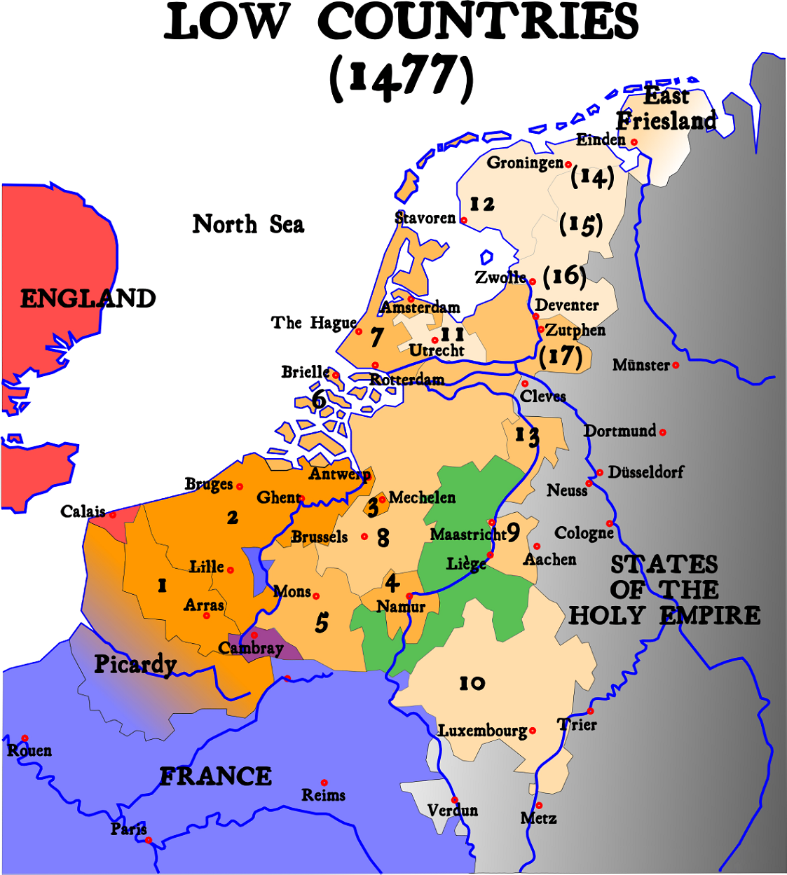
English: Map of Burgundian Netherlands (the Low Countries) in 1477.
Nederlands: Kaart van de Bourgondische Nederlanden (de Lage Landen) in 1477. |
| Крыніца |
English version of Image:1477 Pays-bas bourguignons.svg (see legend there)
|
| Аўтар | Denis Jacquerye |
| Іншыя версіі |
[правіць]
|


Key
- In orange, the acquisitions of the dukes of Burgundy and of Charles V.
- 1384 : Artois (5), Flanders (9), Mechelen (15)
- 1427 : Namur (8)
- 1428 : Hainaut (6), Zeeland (10), Holland (7)
- 1430 : Brabant (1), Limburg (3)
- 1443 : Luxemburg (4)
- Under Charles V
- Utrecht (17), West and East Friesland (13), Guelders (2)
- Provinces which were lost and regained: Groningen (14), Overijssel (16), Zutphen (11)
- Picardy was lost to France in 1477.
- In Green, the independent fiefdom of Liège
- In Red, England
- In Blue, France
- In Black, The other nations of the Holy Roman Empire
The 17 Provinces
|

|
This historical map image could be re-created using vector graphics as an SVG file. This has several advantages; see Commons:Media for cleanup for more information. If an SVG form of this image is available, please upload it and afterwards replace this template with
{{vector version available|new image name}}.
It is recommended to name the SVG file “Map Burgundian Netherlands 1477-en.svg”—then the template Vector version available (or Vva) does not need the new image name parameter. |
Белым на севере отмечены страны вышедшие из состава семнадцати провинций и образовавшие республику семи провинций
Ліцэнзіяванне
- Вы можаце свабодна:
- дзяліцца творам – капіраваць, распаўсюджваць і перадаваць гэты твор.
- ствараць вытворныя творы – адаптаваць гэты твор
- Пры выкананні наступных умоў:
- атрыбуцыя – вы павінны пазначыць аўтарства гэтага твора, даць спасылку на ліцэнзію і пазначыць ці рабіў аўтар якія-небудзь змены. Гэта можна рабіць кожным зразумелым чынам, але не так, каб наводзіць па думку, што ліцэнзіят падтрымлівае вас або выкарыстанне вамі гэтага твора.
- распаўсюджванне на тых жа ўмовах – If you alter, transform, or build upon this work, you must distribute the resulting work under the same license as the original.

|
Textual information (e.g. timestamp) once visible in the image itself has been moved into the image metadata and/or image description page. This makes the image easier to reuse and more language-neutral, and makes the text easier to process and search for. Commons discourages placing visible textual information in images. All licenses accepted on Commons permit this type of modification as a derivative work.
If attribution information were removed and the image is not public domain, replace this tag with {{Attribution metadata from licensed image}}.
беларуская (тарашкевіца) | català | Deutsch | English | español | فارسی | français | galego | magyar | italiano | македонски | മലയാളം | português | русский | sicilianu | slovenščina | svenska | Indonesia | 中文 | +/− |
Назвы
Элементы, адлюстраваныя на гэтым файле
адлюстроўвае
image/png
Гісторыя файла
Націснуць на даце з часам, каб паказаць файл, якім ён тады быў.
| Дата і час | Драбніца | Памеры | Удзельнік | Тлумачэнне | |
|---|---|---|---|---|---|
| актуальн. | 10:20, 21 чэрвеня 2023 | | 1 123 × 1 249 (825 KB) | Artanisen | Higher quality (same map) |
| 07:31, 1 лютага 2007 |  | 591 × 657 (142 KB) | Dcoetzee | Remove watermark and pngcrush | |
| 17:14, 9 студзеня 2005 |  | 591 × 657 (175 KB) | Moyogo | ||
| 21:26, 25 снежня 2004 |  | 520 × 578 (146 KB) | Moyogo | Map of the Low Countries in 1477 |
Выкарыстанне файла
Наступная 1 старонка выкарыстоўвае гэты файл:
Глабальнае выкарыстанне файла
Гэты файл выкарыстоўваецца ў наступных вікі:
- Выкарыстанне ў an.wikipedia.org
- Выкарыстанне ў ar.wikipedia.org
- Выкарыстанне ў bg.wikipedia.org
- Выкарыстанне ў ca.wikipedia.org
- Выкарыстанне ў cs.wikipedia.org
- Выкарыстанне ў da.wikipedia.org
- Выкарыстанне ў de.wikipedia.org
- Выкарыстанне ў el.wikipedia.org
- Выкарыстанне ў en.wikipedia.org
- Выкарыстанне ў et.wikipedia.org
- Выкарыстанне ў eu.wikipedia.org
- Выкарыстанне ў fa.wikipedia.org
- Выкарыстанне ў fi.wikipedia.org
- Выкарыстанне ў fr.wikipedia.org
- Выкарыстанне ў gag.wikipedia.org
- Выкарыстанне ў gl.wikipedia.org
- Выкарыстанне ў he.wikipedia.org
- Выкарыстанне ў hi.wikipedia.org
- Выкарыстанне ў id.wikipedia.org
- Выкарыстанне ў io.wikipedia.org
- Выкарыстанне ў it.wikipedia.org
Паказаць глабальнае выкарыстанне гэтага файла.
Метаданыя
У файле ёсць дадатковыя звесткі, магчыма, дададзеныя лічбавай фотакамерай ці сканерам, з якіх гэты файл паходзіць. Калі арыгінальны файл быў зменены, то частка гэтых звестак магла страціць актуальнасць у дачыненні да змененага файла.
| Гарызантальная раздзяляльнасць | 47,24 dpc |
|---|---|
| Вертыкальная раздзяляльнасць | 47,24 dpc |