Файл:Dasht-e_Kavir.jpg
From Wikipedia, the free encyclopedia
Оригинален файл (5822 × 5820 пиксела, големина на файла: 3,5 МБ, MIME-тип: image/jpeg)
| Този файл е от Общомедия и може да се използва от други проекти.
Следва информация за файла, достъпна през оригиналната му описателна страница. |
Резюме
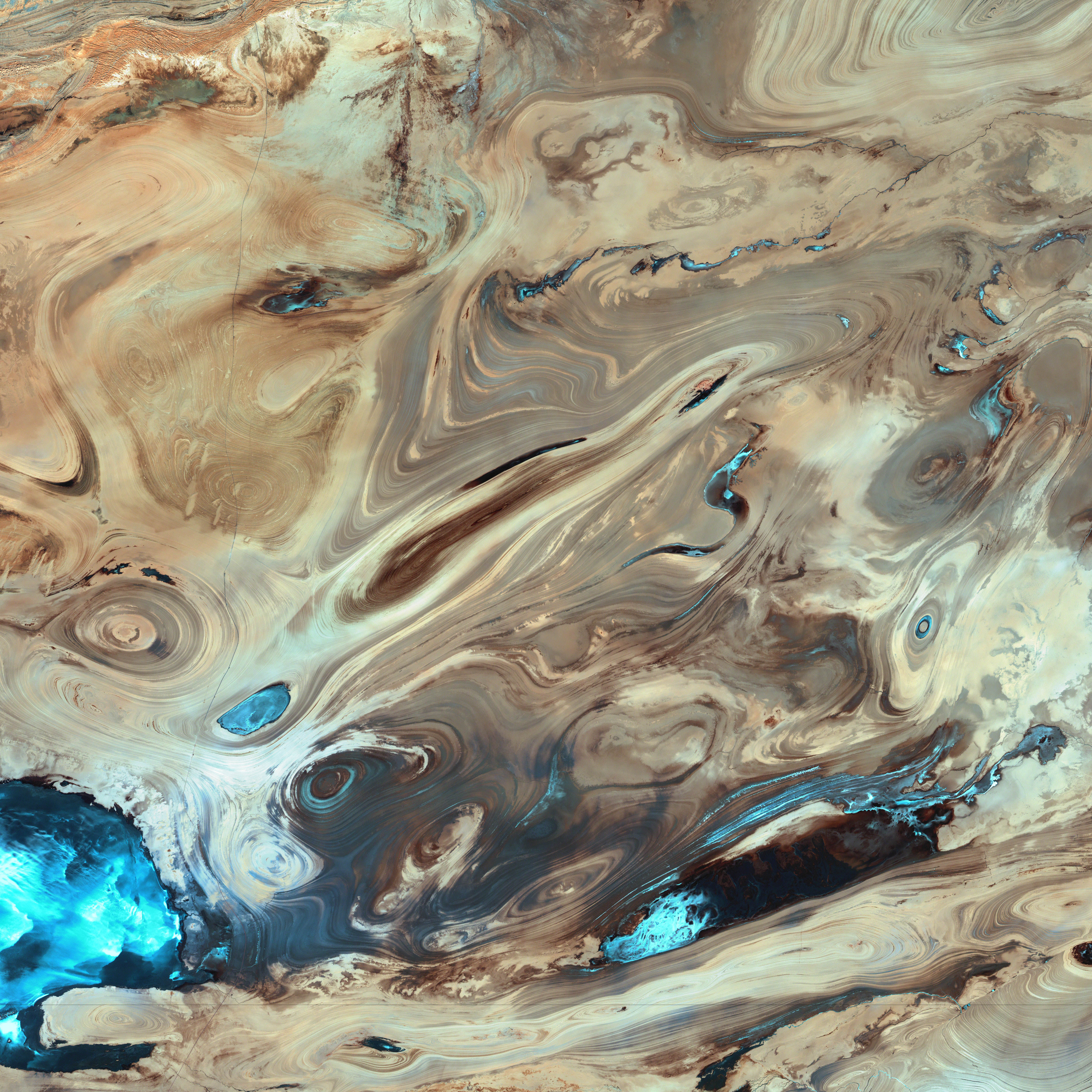
| ОписаниеDasht-e Kavir.jpg |
English: A satellite picture of the Dasht-e Kavir desert in Iran.
The patterns you see are formed by different geological layers that have been eroded over thousands of years by wind and sometimes (but not often) rain. The patterns are formed from either horizontal geological layers cut through by topographic changes, or geological formations (folds, domes, etc) in relatively flat terrain. Most of the colours are due to chemical differences in the rocks, whilst the intense blue colours could be due to a range of materials, possibly salt deposits, possibly vegetation, depending on which area of the EM spectrum is represented by blue. I suspect (but don't know, the satellite bands to displayed colours are not mentioned) that the blue colours are salt deposits, but they could equally be other materials too. To be certain, knowledge of the bands to display colours is essential. The black line running horizontally across the image is a sensor drop-out and the data for that line or lines has been irrevocably lost. The linear (but not straight) line running vertically down the middle left is a road. USGS/NASA description: The Dasht-e Kevir, or Great Salt Desert, is the largest desert in Iran. It is primarily uninhabited wasteland, composed of mud and salt marshes covered with crusts of salt that protect the meager moisture from completely evaporating. This image was acquired by Landsat 7’s Enhanced Thematic Mapper plus (ETM+) sensor on October 24, 2000. This is a false-color composite image made using infrared, green, and red wavelengths. The image has also been sharpened using the sensor’s panchromatic band.فارسی: تصویر ماهوارهای از دشت کویر ایران. اکثر رنگهای موجود در نگاره و تفاوتهای شیدهای مختلف، به دلایل اختلافهای ترکیبات شیمیایی مواد تشکیل دهنده صخرهها و تپهها است که در کنار یکدیگر جلوهگر شدهاند. رنگهای تند آبی احتمالاً ناشی از رسوب نمکهای باقی مانده از رستنیها و گیاهان کویری است. البته این استنتاج بستگی مستقیم به طیف الکترومغناطیسی دارد که با رنگ آبی نمایش داده شدهاست. |
| Дата | |
| Източник | NASA Earth Observatory. |
| Автор | USGS EROS Data Center Satellite Systems Branch. |
| Object location | 34° 45′ 18,82″ N, 54° 51′ 45,1″ E | View this and other nearby images on: OpenStreetMap |
|---|
(centre of image)
Лицензиране
| Public domainPublic domainfalsefalse |
| This file is in the public domain in the United States because it was solely created by NASA. NASA copyright policy states that "NASA material is not protected by copyright unless noted". (See Template:PD-USGov, NASA copyright policy page or JPL Image Use Policy.) | ||
 |
Warnings:
|
| Public domainPublic domainfalsefalse |
Това изображение е обществено достояние. Защото съдържа материал разработен от Юнайтид стейтс джиолоджикал сървей, агенция на Интериорният департамент на САЩ. За повече информация, вижте the official USGS copyright policy.
Bahasa Indonesia ∙ català ∙ čeština ∙ Deutsch ∙ eesti ∙ English ∙ español ∙ français ∙ galego ∙ italiano ∙ Nederlands ∙ português ∙ polski ∙ sicilianu ∙ suomi ∙ Tiếng Việt ∙ Türkçe ∙ български ∙ македонски ∙ русский ∙ മലയാളം ∙ 한국어 ∙ 日本語 ∙ 中文 ∙ 中文(简体) ∙ 中文(繁體) ∙ العربية ∙ فارسی ∙ +/− |
|
| Annotations InfoField | This image is annotated: View the annotations at Commons |
sensor drop-out
section of road
Описания
Items portrayed in this file
изобразен обект
Commons quality assessment английски
Wikimedia Commons featured picture английски
24 октомври 2000
coordinates of depicted place английски
34°45'18.821"N, 54°51'45.101"E
media type английски
image/jpeg
История на файла
Избирането на дата/час ще покаже как е изглеждал файлът към онзи момент.
| Дата/Час | Миникартинка | Размер | Потребител | Коментар | |
|---|---|---|---|---|---|
| текуща | 20:39, 18 януари 2006 | | 5822 × 5820 (3,5 МБ) | David.Monniaux | ran it through jpegtran to output optimized, non-progressive jpeg |
| 20:09, 18 януари 2006 |  | 5822 × 5820 (3,66 МБ) | Palladinus | Dasht-e Kavir desert in Iran |
Използване на файла
Следната страница използва следния файл:
Глобално използване на файл
Този файл се използва от следните други уикита:
- Употреба в als.wikipedia.org
- Употреба в ar.wikipedia.org
- Употреба в azb.wikipedia.org
- Употреба в az.wikipedia.org
- Употреба в be.wikipedia.org
- Употреба в bs.wikipedia.org
- Употреба в ca.wikipedia.org
- Употреба в cs.wikipedia.org
- Употреба в de.wikipedia.org
- Употреба в en.wikipedia.org
- Употреба в es.wikipedia.org
- Употреба в es.wikibooks.org
- Употреба в es.wikisource.org
- Употреба в et.wikipedia.org
- Употреба в eu.wikipedia.org
- Употреба в fa.wikipedia.org
- دشت کویر
- ویکیپدیا:انتخاب نگاره هفته/سال ۲۰۱۱/هفته ۱
- ویکیپدیا:انتخاب نگاره هفته/سال ۲۰۱۱/هفته ۱/کویر مرکزی ایران
- ویکیپدیا:نگارههای برگزیده/پدیدههای طبیعی
- ویکیپدیا:نگارههای برگزیده/علمی/زمینشناسی
- ویکیپدیا:گزیدن نگاره برگزیده/فوریه-۲۰۱۲
- ویکیپدیا:نگاره روز/ژوئن ۲۰۱۲
- ویکیپدیا:گزیدن نگاره برگزیده/Dasht-e Kavir.jpg
- الگو:نر/2012-06-21
- الگو:نر محافظت شده/2012-06-21
- بحث کاربر:Alborzagros/بایگانی ۵
- درگاه:علوم زمین/نگاره برگزیده/۲
- درگاه:علوم زمین/نگاره برگزیده
- تصویربرداری ماهوارهای
- Употреба в fr.wikipedia.org
- Употреба в gd.wikipedia.org
- Употреба в gl.wikipedia.org
- Употреба в hr.wikipedia.org
- Употреба в id.wikipedia.org
- Употреба в incubator.wikimedia.org
Преглед на глобалната употреба на файла.
Метаданни
Файлът съдържа допълнителни данни, обикновено добавяни от цифровите апарати или скенери. Ако файлът е редактиран след създаването си, то някои параметри може да не съответстват на текущото изображение.
| _error | 0 |
|---|