File:East-Hem_1000bc.jpg
From Wikipedia, the free encyclopedia
Fitxer original (3.240 × 1.903 píxels, mida del fitxer: 1,43 Mo, tipus MIME: image/jpeg)
| Aquest fitxer i la informació mostrada a continuació provenen del dipòsit multimèdia lliure Wikimedia Commons. |

|
Aquesta imatge (de tipus historical map) s'hauria de tornar a crear utilitzant gràfics vectorials com ara un fitxer SVG. Això té diversos avantatges; en trobareu més informació a Commons:Media for cleanup. Si ja disposeu d'una versió d'aquesta imatge en format SVG, us preguem que la pengeu; després, reemplaceu aquesta plantilla amb la plantilla {{Vector version available|nom nou de la imatge.svg}} en aquesta imatge.
|
 | Aquesta imatge, o les imatges d'aquest article o categoria, ha estat carregada en format JPEG. Tanmateix, conté informació que es podria emmagatzemar més eficaçment o més acuradament en el format PNG o SVG. Si és possible, us preguem que carregueu una versió PNG o SVG d'aquesta imatge sense algoritmes de compressió, derivada d'una font no JPEG o sense codificació de compressió. |  |
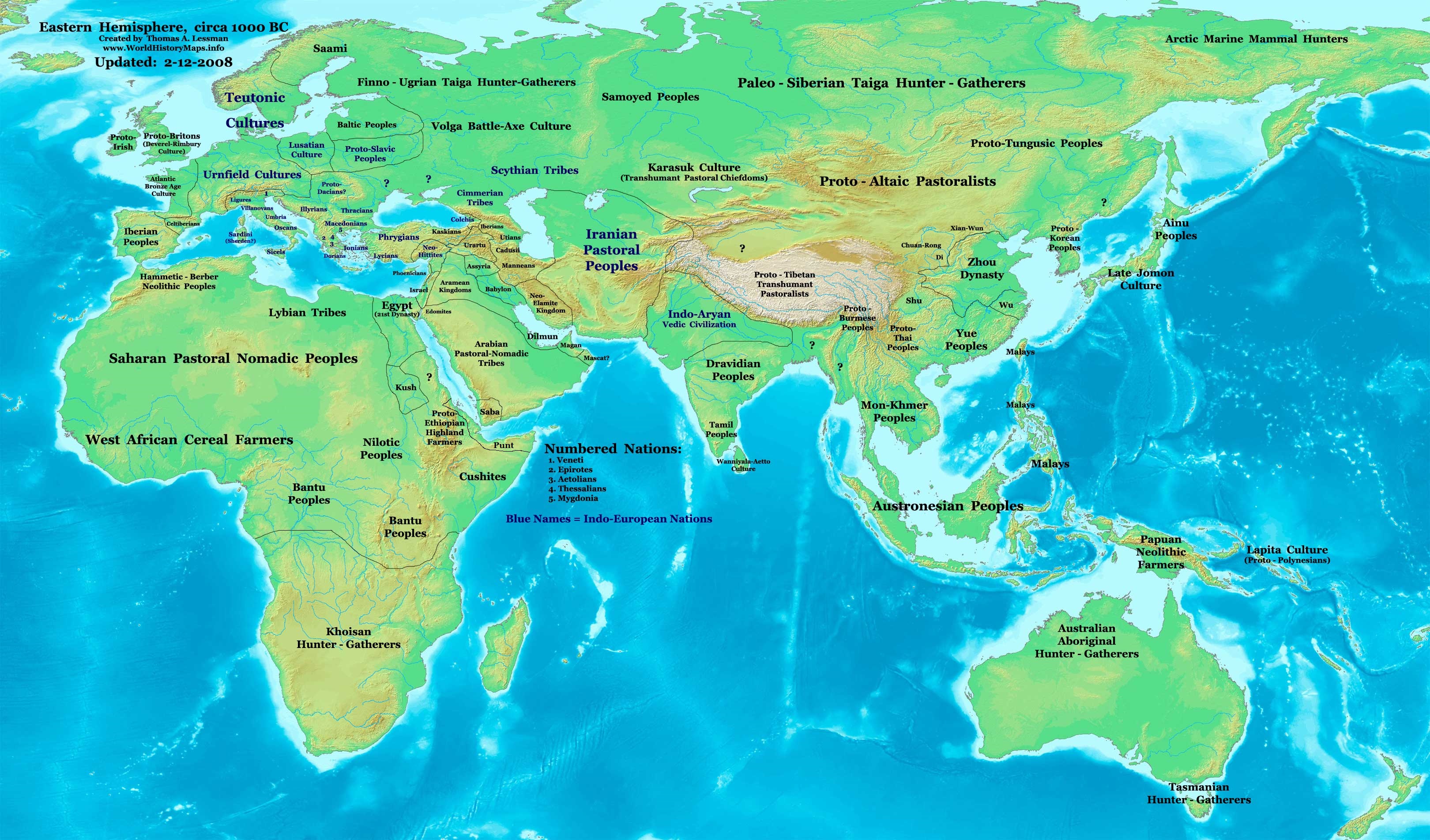
| DescripcióEast-Hem 1000bc.jpg | Eastern Hemisphere in 1000 BC. |
| Font | self-made (For reference information, see below) |
| Autor | Thomas Lessman (Contact!) |
| Altres versions | see East-Hem_1000bc.jpg file history on Wikipedia. |
Llicència
- Sou lliure de:
- compartir – copiar, distribuir i comunicar públicament l'obra
- adaptar – fer-ne obres derivades
- Amb les condicions següents:
- reconeixement – Heu de donar la informació adequada sobre l'autor, proporcionar un enllaç a la llicència i indicar si s'han realitzat canvis. Podeu fer-ho amb qualsevol mitjà raonable, però de cap manera no suggereixi que l'autor us dóna suport o aprova l'ús que en feu.
- compartir igual – Si modifiqueu, transformeu, o generareu amb el material, haureu de distribuir les vostres contribucions sota una llicència similar o una de compatible com l'original
Map Summary
Original Source URL: http://www.thomaslessman.com/History/images/East-Hem_1000bc.jpg.
This map of the Eastern Hemisphere in 1000 BC was created by Thomas Lessman, based on information from the sources listed below. This map is free for educational use (see Permission info above). When using this map, please mention that it is available for free at www.WorldHistoryMaps.info.
Map Source References
- Remember, sources often conflict with each other. This map is only as accurate as the information that is available to me. To report any errors or to help further this work, please click here, or email Thomas Lessman at talessman@yis.us
References for information contained in this map:
1. Some info derive from the map of the World 1000 BCE, created by User:Briangotts..
2. Zhou (China) borders derive partially from the Huhai.net map of China: 11th to 9th centuries BC.
3. Some information derives from DK Atlas of World History, 2000 edition.
4. Other information is based on various Wikipedia articles and google searches dealing with nations depicted in this map.
Other Maps by Thomas Lessman
| Maps of the eastern hemisphere showing history
Bold dates are available on Wikimedia or Wikipedia. | ||
| Primeval | ||
| Ancient
|
·| 600 BC | 550 BC | 527 BC | 500 BC |
400 BC | ·| 1 AD | 50 AD | 100 AD | 200 AD | 300 AD | | |
| Medieval |
·| 500 AD | 565 AD | 600 AD | 700 AD | | |
| Modern |
·| 1500 AD | · * For historical maps of the whole world, | |
| history links talk edit view | ||
| Anotacions InfoField | Aquesta imatge té anotacions: Vegeu-les a Commons |


Llegendes
Elements representats en aquest fitxer
representa l'entitat
Algun valor sense element de Wikidata
Historial del fitxer
Cliqueu una data/hora per veure el fitxer tal com era aleshores.
| Data/hora | Miniatura | Dimensions | Usuari/a | Comentari | |
|---|---|---|---|---|---|
| actual | 13:13, 28 set 2023 | | 3.240 × 1.903 (1,43 Mo) | Notradeuussrs | added Punt |
| 09:15, 9 maig 2008 |  | 3.240 × 1.903 (720 Ko) | Talessman | {{Information |Description='''Eastern Hemisphere in 1000 BC'''. |Source=self-made (For reference information, see below) |Author=Thomas Lessman (Contact!) |Date= |Location= |Permission={{self|cc-by-sa-3.0}} |othe |
Ús del fitxer
No hi ha pàgines que utilitzin aquest fitxer.
Ús global del fitxer
Utilització d'aquest fitxer en altres wikis:
- Utilització a ar.wikipedia.org
- Utilització a en.wikipedia.org
- Chaldea
- 1st millennium BC
- 2nd millennium BC
- 10th century BC
- 1000s BC (decade)
- Indo-Iranians
- Late Bronze Age collapse
- User:Talessman/Maps
- User talk:Talessman/Maps
- List of political entities in the 10th century BC
- User:Benjamin Trovato/sandbox
- Transjordan (region)
- User:Falcaorib/Ancient East Hemisphere
- Utilització a fr.wikipedia.org
- Utilització a gl.wikipedia.org
- Utilització a hy.wikipedia.org
- Utilització a hyw.wikipedia.org
- Utilització a ro.wikipedia.org
- Utilització a sv.wikipedia.org
- Utilització a tr.wikipedia.org
Metadades
Aquest fitxer conté informació addicional, probablement afegida per la càmera digital o l'escàner utilitzat per a crear-lo o digitalitzar-lo. Si s'ha modificat posteriorment, alguns detalls poden no reflectir les dades reals del fitxer modificat.
| Orientació | Normal |
|---|