File:Frisiae-edited.jpg
From Wikipedia, the free encyclopedia
Fitxer original (2.878 × 2.225 píxels, mida del fitxer: 1,71 Mo, tipus MIME: image/jpeg)
| Aquest fitxer i la informació mostrada a continuació provenen del dipòsit multimèdia lliure Wikimedia Commons. |
Resum
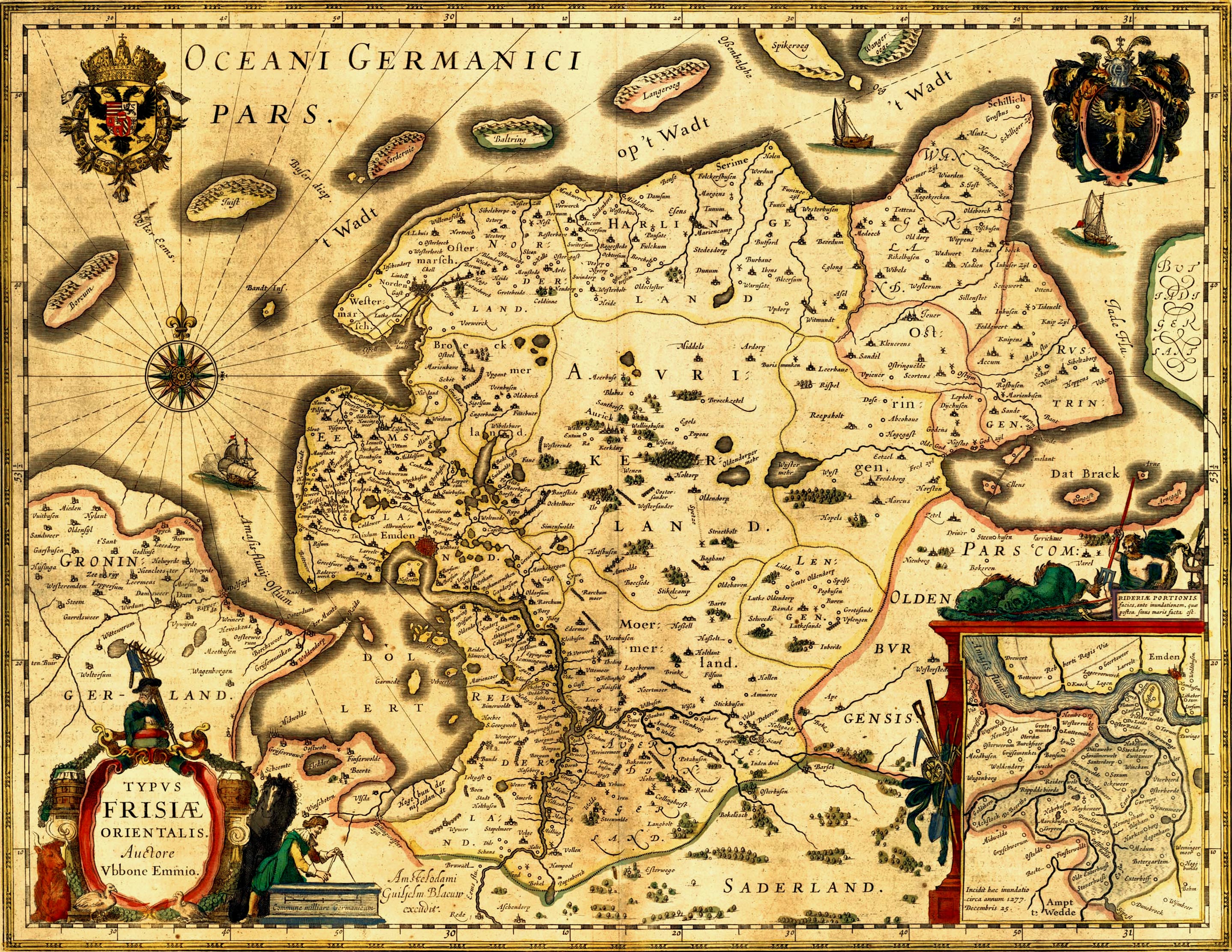
| DescripcióFrisiae, about 1600, by Ubbo Emmius.jpg |
Deutsch: Alte Karte von Ostfriesland. English: Old map of East Frisia. Plattdüütsch: aulte landkoort vun Oostfreesland Español: mapa antigua de Frisia oriental |
|||||||||||||||||||||||
| Data |
cap a 1600 date QS:P,+1600-00-00T00:00:00Z/9,P1480,Q5727902 |
|||||||||||||||||||||||
| Font | http://www.library.ucla.edu/yrl/reference/maps/blaeu/frisiae.jpg (deprecated link) | |||||||||||||||||||||||
| Creador |
creator QS:P170,Q399131 |
|||||||||||||||||||||||
| Permís (Com reutilitzar aquest fitxer) |
public domain because of age | |||||||||||||||||||||||
| Georeferencing | View the georeferenced map in the Wikimaps Warper | |||||||||||||||||||||||
| Altres versions |

Note: The colors may be adjusted again in the future. I did it on a TFT. ^.^ A 500dpi TIFF version can be ordered here: http://www.library.ucla.edu/yrl/reference/maps/blaeu/germania.htm (deprecated link) |
|||||||||||||||||||||||
.jpg)
| Public domainPublic domainfalsefalse |
|
Aquest material està en domini públic als Estats Units i als altres països on el dret d'autor s'estén per 70 anys (o menys) després de la mort de l'autor.
| |
| Aquest fitxer està identificat com a lliure de restriccions conegudes sota la llei de drets d'autor, inclosos els drets veïns. | |
https://creativecommons.org/publicdomain/mark/1.0/PDMCreative Commons Public Domain Mark 1.0falsefalse
Llegendes
Elements representats en aquest fitxer
representa l'entitat
image/jpeg
Historial del fitxer
Cliqueu una data/hora per veure el fitxer tal com era aleshores.
| Data/hora | Miniatura | Dimensions | Usuari/a | Comentari | |
|---|---|---|---|---|---|
| actual | 00:03, 17 gen 2007 | | 2.878 × 2.225 (1,71 Mo) | Enricopedia | {{Information |Description= {{de|Alte Karte von Ostfriesland.}}{{en|Old map of East Frisia.}} |Source= http://www.library.ucla.edu/yrl/reference/maps/blaeu/frisiae.jpg |Date=14th century |Author=[[:de:Ubbo Emmius|Ub |
Ús del fitxer
No hi ha pàgines que utilitzin aquest fitxer.
Ús global del fitxer
Utilització d'aquest fitxer en altres wikis:
- Utilització a azb.wikipedia.org
- Utilització a da.wikipedia.org
- Utilització a de.wikipedia.org
- 1600
- Jadebusen
- Ostfriesland
- Dollart
- Norderney
- Cirksena
- Norden (Ostfriesland)
- Wittmund
- Bockhorn (Friesland)
- Arngast
- Sande (Friesland)
- Rüstringen
- Leybucht
- Harlebucht
- Geschichte Ostfrieslands
- Heppens
- Schwarzes Brack
- Neustadtgödens
- Auricherland
- Wikipedia:WikiProjekt Ostfriesland/Kartenzimmer
- Diskussion:Ostfriesland/Archiv/1
- Grafschaft Ostfriesland
- Steinhaus Bunderhee
- Antoniflut
- Diskussion:Norderney/Archiv/1
- Ostfriesland zur Zeit des Dreißigjährigen Krieges
- Wikipedia Diskussion:Hauptseite/Artikel des Tages/Archiv/Vorschläge/2010/1
- Wikipedia Diskussion:Hauptseite/Archiv/2010/Januar
- Portal:Ostfriesland/Ausgezeichnet
- Portal:Ostfriesland/EA
- Itzendorf
- Mariensiel
- Wikipedia Diskussion:WikiProjekt Ostfriesland/Archiv/2010
- Bucht von Sielmönken
- Maadebucht
- Herrlichkeit Gödens
- Crildumer Bucht
- Ellenser Damm
- Wikipedia Diskussion:Hauptseite/Artikel des Tages/Archiv/Vorschläge/2014/Q2
- Wikipedia:Hauptseite/Archiv/20. April 2014
- Hilgenrieder Bucht
- Vorlage:Navigationsleiste Meeresbuchten und ehemalige Meeresbuchten auf der Ostfriesischen Halbinsel
- Benutzer:GregorHelms/Falstertief
- Utilització a de.wikisource.org
- Utilització a en.wikipedia.org
Vegeu més usos globals d'aquest fitxer.