Fitxer:Manhattan_1931.jpg
From Wikipedia, the free encyclopedia
Fitxer original (1.467 × 1.044 píxels, mida del fitxer: 282 Ko, tipus MIME: image/jpeg)
| Aquest fitxer i la informació mostrada a continuació provenen del dipòsit multimèdia lliure Wikimedia Commons. |
Resum
| DescripcióManhattan 1931.jpg |
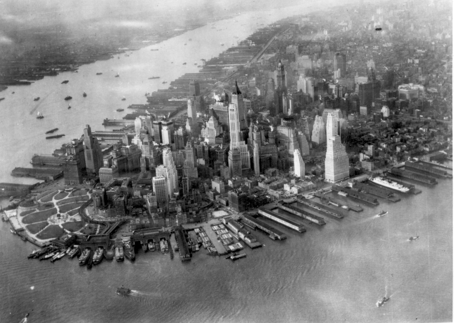
English: Aerial view of the tip of Manhattan, New York, United States ca. 1931. Note that the Cities Service Building (now known as the American International Building or 70 Pine Street), which would become lower Manhattan's tallest building in 1932, is only partially completed.
Français : Vue aérienne de la pointe de Manhattan, à New York, aux États Unis, prise vers 1931. Noter le Cities Service Building (American International Building, 70 Pine Street) qui devait devenir le bâtiment le plus haut de l'île en 1932, et qui est en construction.
Deutsch: Luftbild der Spitze Manhattans, New York, Vereinigte Staaten um 1932. Erwähnenswert ist, dass das Cities Service Building (mittlerweile als American International Building oder 70 Pine Street bekannt), welches das höchste Gebäude von Lower Manhattan 1932 wurde, noch nicht vollständig erbaut worden ist.
Suomi: Ilmakuva Manhattanista (New York, USA) noin vuodelta 1931
Shqip: Pamje e majës të Manhattan-it, New York, Shtetet e Bashkuara nga ajri afërsisht në vitin 1931. Shëno që ndërtesa Cities Service Building (e njohur poashtu si American International Building), e cila do të bëhet ndërtesa më e lartë e Lower Manhattan-it në vitin 1932, është e kompletuar vetëm pjesërisht. |
| Data |
cap a 1931 date QS:P,+1931-00-00T00:00:00Z/9,P1480,Q5727902 |
| Font |
U.S. National Archives Original file: american_cities_047.jpg |
| Autor | DesconegutUnknown author |
| Altres versions |
|

|
Aquesta imatge va ser escollida imatge del dia el 14 April 2005. La seva descripció va ser la següent: Altres idiomes:
Cymraeg: Ynys Manhattan, Efrog Newydd, UDA. (1942) Deutsch: Luftbild von Manhattan, New York, 1942 English: Aerial view of the tip of Manhattan, New York, 1942 Français : Vue aérienne de Manhattan, New York, 1942. Galego: Nova York Norsk bokmål: Flybilde av Manhattan i New York i 1942. Polski: Zdjęcie lotnicze Manhattanu (Nowy Jork, 1942) Português: Vista aérea da ponta de Manhattan, Nova Iorque, 1942 Slovenščina: Panoramski pogled na Manhattan, New York, 1942 Suomi: Ilmakuva Manhattanin niemestä 1942 Svenska: Flygbild över Manhattan, New York - 1942 Беларуская: Манхэтан (Ню-Ёрк) з вышыні. Українська: Вигляд Манхеттона з повітря ไทย: มุมมองทางอากาศจากปลายสุดเกาะแมนฮัตตัน, นครนิวยอร์ก ค.ศ. ๑๙๔๒ 日本語: マンハッタンの航空写真(1942年・ニューヨーク) |
Llicència
| Public domainPublic domainfalsefalse |
Aquesta obra és en el domini públic als Estats Units perquè és una obra del govern federal dels Estats Units sota els termes del Títol 17, Capítol 1, Secció 105 del Codi dels EUA. Vegeu drets d'autor.
Nota: Això només s'aplica a obres del Govern Federal i no a les dels estats individuals ni cap altra subdivisió administrativa. Aquesta plantilla tampoc no s'aplica a dissenys de segells de correus publicats pel Servei Postal dels Estats Units des de 1978 (vegeu 206.02(b) of Compendium II: Copyright Office Practices).
|
 | |
| Aquest fitxer està identificat com a lliure de restriccions conegudes sota la llei de drets d'autor, inclosos els drets veïns. | ||
https://creativecommons.org/publicdomain/mark/1.0/PDMCreative Commons Public Domain Mark 1.0falsefalse
Registre original de càrregues
| date/time | username | resolution | size | edit summary |
|---|---|---|---|---|
| 2005-03-05T04:13:17Z | User:Apollomelos | 1467×1044 | 282.21Kb | {{PD}} |
| Anotacions InfoField | Aquesta imatge té anotacions: Vegeu-les a Commons |
90 Broad Street, Stone & Webster Building
104 Broad Street
76 Beaver Street, 11 Hanover Square
100 Maiden Lane
90-100 John Street
Llegendes
Elements representats en aquest fitxer
representa l'entitat
Historial del fitxer
Cliqueu una data/hora per veure el fitxer tal com era aleshores.
| Data/hora | Miniatura | Dimensions | Usuari/a | Comentari | |
|---|---|---|---|---|---|
| actual | 18:23, 13 ago 2009 | | 1.467 × 1.044 (282 Ko) | BetacommandBot | move approved by: User:Yann This image was moved from File:Manhattan1942.jpg {{Information | Description = {{en|Aerial view of the tip of Manhattan, New York, United States ca. 1931. Note that the Cities Service Building (now known as the [ |
Ús del fitxer
Les 3 pàgines següents utilitzen aquest fitxer:
Ús global del fitxer
Utilització d'aquest fitxer en altres wikis:
- Utilització a af.wikipedia.org
- Utilització a als.wikipedia.org
- Utilització a ar.wikipedia.org
- Utilització a ba.wikipedia.org
- Utilització a cs.wikipedia.org
- Utilització a de.wikipedia.org
- Utilització a en.wikipedia.org
- Lower Manhattan
- History of New York City (1898–1945)
- Portal:New York City
- Wikipedia:Picture peer review/Manhattan1942
- Wikipedia:Picture peer review/Archives/Archive2006
- User:Passargea/Favourite pictures/Other
- Wikipedia:Featured picture candidates/delist/2008
- Wikipedia:Featured picture candidates/delist/Image:Uss-akron-manhattan.jpg
- James Rossant
- User:Arthena/DE list 60
- User:Arthena/DE list 61
- Utilització a en.wikiquote.org
- Utilització a es.wikipedia.org
- Utilització a et.wikipedia.org
- Utilització a eu.wikipedia.org
- Utilització a fa.wikipedia.org
- Utilització a fi.wikipedia.org
- Utilització a fr.wikipedia.org
Vegeu més usos globals d'aquest fitxer.
Metadades
Aquest fitxer conté informació addicional, probablement afegida per la càmera digital o l'escàner utilitzat per a crear-lo o digitalitzar-lo. Si s'ha modificat posteriorment, alguns detalls poden no reflectir les dades reals del fitxer modificat.
| Comentari del fitxer JPEG | U-Lead Systems, Inc. |
|---|