Datei:Rb-map.png
aus Wikipedia, der freien encyclopedia
Rb-map.png (328 × 352 Pixel, Dateigröße: 13 KB, MIME-Typ: image/png)
![]()
Diese Datei und die Informationen unter dem roten Trennstrich werden aus dem zentralen Medienarchiv Wikimedia Commons eingebunden.
![]()
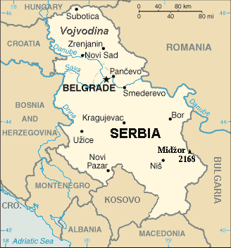
| BeschreibungRb-map.png | Map of the Republic of Serbia (FIPS 10 country code standard: RB) | ||||
| Datum | |||||
| Quelle | The World Factbook (published by CIA in 2008). | ||||
| Urheber | Central Intelligence Agency of the Government of the United States of America | ||||
| Genehmigung (Weiternutzung dieser Datei) |
|
||||
| Andere Versionen | Recommend that Image:Sr-map.png should be deleted and Image:Serbia-CIA WFB Map.png should be spared to show how the map looked before 2008. |
Inhaltsverzeichnis
Beschreibung
Map of Serbia from The World Factbook Archivkopie in der Wayback Machine (published by CIA in 2008).
This map is updated with current events; independence of Kosovo and certain faults like BUL. is replaced with BULGARIA. The name of the country is in bold font, like the name of the Autonomous Province of Vojvodina (Northern Serbian province). Also the highest mountain in Serbia (Central Serbia region) is marked at the border with Bulgaria with the name of that peak - Midžor - and added the height in meters.
The name of the file
The National Geospatial-Intelligence Agency maintains the FIPS 10 country code standard that US Government use.
On 2006-07-11 the following changes have been made:
DELETE the following geopolitical entities and codes:
- YI SERBIA AND MONTENEGRO
- YI01 Crna Gora (Montenegro)
- YI02 Srbija (Serbia)
ADD the following geopolitical entity and code:
- MJ MONTENEGRO
ADD the following geopolitical entity and code:
- RB SERBIA
The notice was issued by:
Randall E. Flynn
Geographer
National Geospatial-Intelligence Agency
GEOnet Names Server at this web-site.
Recommend that Image:Sr-map.png should be deleted and Image:Serbia-CIA WFB Map.png should be spared to show how the map looked before 2008.
Lizenz
| Public domainPublic domainfalsefalse |
Dieses Werk ist gemeinfrei, weil es Bildmaterial aus dem CIA World Factbook darstellt, das ursprünglich vom Zentralen Nachrichtendienst der Vereinigten Staaten veröffentlicht wurde.
Bahasa Indonesia ∙ čeština ∙ Deutsch ∙ eesti ∙ English ∙ español ∙ Esperanto ∙ français ∙ galego ∙ hrvatski ∙ italiano ∙ Nederlands ∙ norsk nynorsk ∙ polski ∙ português ∙ sicilianu ∙ slovenščina ∙ suomi ∙ Türkçe ∙ Zazaki ∙ беларуская (тарашкевіца) ∙ македонски ∙ русский ∙ српски / srpski ∙ українська ∙ ქართული ∙ বাংলা ∙ தமிழ் ∙ മലയാളം ∙ 한국어 ∙ 日本語 ∙ 中文 ∙ 中文(简体) ∙ 中文(繁體) ∙ العربية ∙ +/− |
 |
For enhancements
| Public domainPublic domainfalsefalse |
| Ich, der Urheberrechtsinhaber dieses Werkes, veröffentliche es als gemeinfrei. Dies gilt weltweit. In manchen Staaten könnte dies rechtlich nicht möglich sein. Sofern dies der Fall ist: Ich gewähre jedem das bedingungslose Recht, dieses Werk für jedweden Zweck zu nutzen, es sei denn, Bedingungen sind gesetzlich erforderlich. |
Kurzbeschreibungen
In dieser Datei abgebildete Objekte
Motiv
28. Februar 2008
Dateiversionen
Klicke auf einen Zeitpunkt, um diese Version zu laden.
| Version vom | Vorschaubild | Maße | Benutzer | Kommentar | |
|---|---|---|---|---|---|
| aktuell | 23:22, 15. Jan. 2014 | | 328 × 352 (13 KB) | Denniss | Reverted to version as of 19:30, 14 February 2008 |
| 23:13, 15. Jan. 2014 |  | 328 × 352 (36 KB) | Ivan VA | updating borders | |
| 23:12, 15. Jan. 2014 |  | 328 × 352 (36 KB) | Ivan VA | vandalizm | |
| 00:29, 3. Jan. 2014 |  | 328 × 352 (13 KB) | No More Cats | oops, I got the wrong version | |
| 18:11, 2. Jan. 2014 |  | 328 × 352 (13 KB) | No More Cats | Reverted to version as of 12:25, 28 February 2011 - original CIA map | |
| 15:53, 8. Aug. 2013 |  | 328 × 352 (36 KB) | Pokrajac | Reverted to version as of 21:00, 11 February 2011 | |
| 14:25, 28. Feb. 2011 |  | 328 × 352 (13 KB) | IJA | Reverted to version as of 19:30, 14 February 2008 | |
| 23:00, 11. Feb. 2011 |  | 328 × 352 (36 KB) | Pokrajac | {{Information |Description=Map of the Republic of Serbia (FIPS 10 country code standard: RB) |Source=[https://www.cia.gov/library/publications/the-world-factbook/geos/rb.html The World Factbook] (published by CIA in 2008). |Date=2008-02-28 |Author=Central | |
| 21:30, 14. Feb. 2008 |  | 328 × 352 (13 KB) | Imbris~commonswiki | {{Information |Description=Map of the Republic of Serbia (FIPS 10 country code standard: RB) |Source=[https://www.cia.gov/library/publications/the-world-factbook/geos/rb.html The World Factbook] (published by CIA in 2008). |Date=2008-06-15 |Author=Central |
Dateiverwendung
Die folgende Seite verwendet diese Datei:
Globale Dateiverwendung
Die nachfolgenden anderen Wikis verwenden diese Datei:
- Verwendung auf eo.wikipedia.org
- Verwendung auf he.wikipedia.org
- Verwendung auf nl.wiktionary.org
- Verwendung auf to.wikipedia.org
Metadaten
Diese Datei enthält weitere Informationen (beispielsweise Exif-Metadaten), die in der Regel von der Digitalkamera oder dem verwendeten Scanner stammen. Durch nachträgliche Bearbeitung der Originaldatei können einige Details verändert worden sein.
| Speicherzeitpunkt | 14:13, 8. Apr. 2007 |
|---|---|
| Horizontale Auflösung | 28,34 dpc |
| Vertikale Auflösung | 28,34 dpc |