File:Colonisation_1550.png
From Wikipedia, the free encyclopedia
Εικόνα σε υψηλότερη ανάλυση (3.600 × 1.578 εικονοστοιχεία, μέγεθος αρχείου: 1,14 MB, τύπος MIME: image/png)
|
|
Αυτό το αρχείο και η περιγραφή του προέρχονται από το Wikimedia Commons. Οι πληροφορίες από την σελίδα περιγραφής του εκεί εμφανίζονται παρακάτω. |
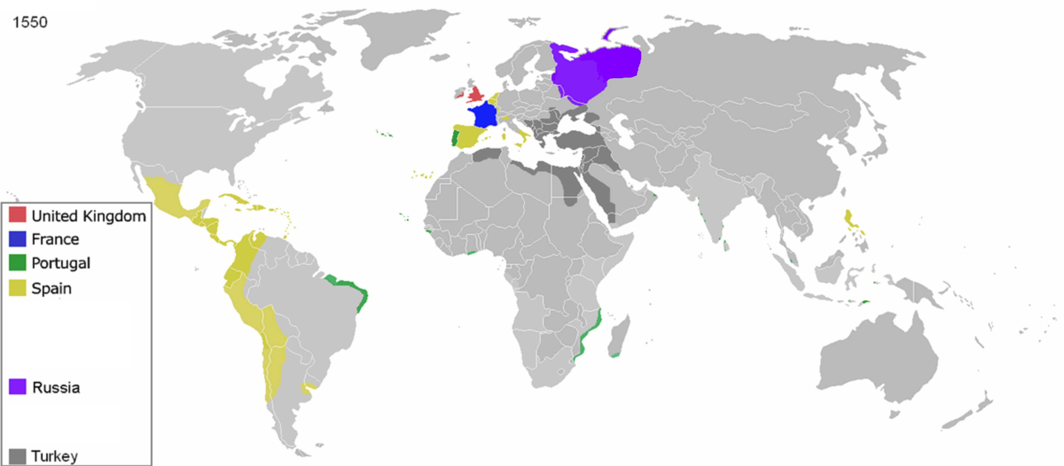
| ΠεριγραφήColonisation 1550.png |
Map of major world powers by year
As the orriginal licence of the animation was Public Domain, this image which has been derived from it is too:
|
|||||||||||||||||||
| Ημερομηνία | ||||||||||||||||||||
| Πηγή | public domain animated map by ArdadN here | |||||||||||||||||||
| Δημιουργός | ArdadN | |||||||||||||||||||
.jpg)
._LOC_2001620596.jpg)

|
This historical map image could be re-created using vector graphics as an SVG file. This has several advantages; see Commons:Media for cleanup for more information. If an SVG form of this image is available, please upload it and afterwards replace this template with
{{vector version available|new image name}}.
It is recommended to name the SVG file “Colonisation 1550.svg”—then the template Vector version available (or Vva) does not need the new image name parameter. |
Λεζάντες
Items portrayed in this file
απεικονίζει
22 Μαρτίου 2007
image/png
checksum Αγγλικά
1518c8ff6198c32258e859d2c3981eec8c6858ea
data size Αγγλικά
1.195.143 Byte
1.578 εικονοστοιχείο
3.600 εικονοστοιχείο
Ιστορικό αρχείου
Κλικάρετε σε μια ημερομηνία/ώρα για να δείτε το αρχείο όπως εμφανιζόταν εκείνη τη στιγμή.
| Ώρα/Ημερομ. | Μικρογραφία | Διαστάσεις | Χρήστης | Σχόλια | |
|---|---|---|---|---|---|
| τελευταία | 11:32, 26 Απριλίου 2020 | | 3.600 × 1.578 (1,14 MB) | Ориенталист | Clarified the territory of Russia by 1550 |
| 09:25, 5 Απριλίου 2020 |  | 3.600 × 1.578 (1,14 MB) | Ориенталист | cosmetic changes | |
| 14:55, 27 Μαρτίου 2020 |  | 4.275 × 1.875 (1,05 MB) | Ориенталист | Clarified the territory of Russia. | |
| 23:25, 3 Μαΐου 2010 |  | 1.425 × 625 (73 KB) | Kieran4 | Fixed errors. | |
| 10:40, 22 Μαρτίου 2007 |  | 1.425 × 625 (65 KB) | Roke~commonswiki | {{Information |Description=Map of major world powers by year {{Maps of world history}} As the orriginal licence of the animation was Public Domain, this image which has been derived from it is too: {{PD-User|Andrei nacu}} |Source=public domain animated m |
Συνδέσεις αρχείου
Δεν υπάρχουν σελίδες που συνδέουν σε αυτό το αρχείο.
Καθολική χρήση αρχείου
Τα ακόλουθα άλλα wiki χρησιμοποιούν αυτό το αρχείο:
- Χρήση σε af.wikipedia.org
- Χρήση σε ast.wikipedia.org
- Χρήση σε bn.wikipedia.org
- Χρήση σε bs.wikipedia.org
- Χρήση σε cs.wikipedia.org
- Χρήση σε de.wikipedia.org
- Χρήση σε en.wikipedia.org
- Χρήση σε es.wikipedia.org
- Χρήση σε fa.wikipedia.org
- Χρήση σε fr.wikipedia.org
- Χρήση σε he.wikipedia.org
- Χρήση σε kk.wikipedia.org
- Χρήση σε mg.wikipedia.org
- Χρήση σε no.wikipedia.org
- Χρήση σε pt.wikipedia.org
- Χρήση σε sk.wikipedia.org
Μεταδεδομένα
Αυτό το αρχείο περιέχει πρόσθετες πληροφορίες, πιθανόν από την ψηφιακή φωτογραφική μηχανή ή το scanner που χρησιμοποιήθηκε για την δημιουργία ή την ψηφιοποίησή της. Αν το αρχείο έχει τροποποιηθεί από την αρχική του κατάσταση, ορισμένες λεπτομέρειες πιθανόν να μην αντιστοιχούν πλήρως στην τροποποιημένη εικόνα.
| Οριζόντια ανάλυση | 37,8 dpc |
|---|---|
| Κατακόρυφη ανάλυση | 37,8 dpc |
| Ημερομηνία και ώρα τελευταίας επεξεργασίας αρχείου | 14:55, 27 Μαρτίου 2020 |