Αρχείο:Britain-fractal-coastline-combined.jpg
From Wikipedia, the free encyclopedia
Δεν διατίθεται υψηλότερη ανάλυση.
Britain-fractal-coastline-combined.jpg (451 × 289 εικονοστοιχεία, μέγεθος αρχείου: 33 KB, τύπος MIME: image/jpeg)
|
|
Αυτό το αρχείο και η περιγραφή του προέρχονται από το Wikimedia Commons. Οι πληροφορίες από την σελίδα περιγραφής του εκεί εμφανίζονται παρακάτω. |
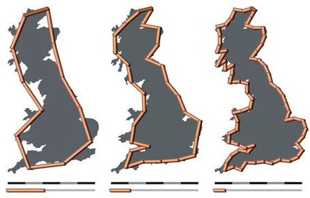
| ΠεριγραφήBritain-fractal-coastline-combined.jpg |
English: The coastline of the United Kingdom as measured with measuring rods of 200 km, 100 km and 50 km in length. The resulting coastline is about 2350 km, 2775 km and 3425 km; the shorter the scale, the longer the measured length of the coast.
Deutsch: Die Küstenlinie Vereinigtes Königreich bei Messung mit unterschliedlich langen Messstäben von 200 km, 100 km und 50 km Länge. Die resultierende Küstenlänge beträgt ungefähr 2350 km, 2775 km bzw. 3425 km, d.h. je kürzer der Massstab, desto länger wird die ermittelte Länge der Küste. |
||||||||
| Ημερομηνία | 6 Μαΐου 2005 (upload date) | ||||||||
| Πηγή |
own work by Avsa
|
||||||||
| Δημιουργός |
originals made by Avsa mixed by Acadac |
||||||||
| Άδεια (Επαναχρησιμοποίηση αυτού του αρχείου) |
|
||||||||
| άλλες εκδόσεις |
|


|
This map image could be re-created using vector graphics as an SVG file. This has several advantages; see Commons:Media for cleanup for more information. If an SVG form of this image is available, please upload it and afterwards replace this template with
{{vector version available|new image name}}.
It is recommended to name the SVG file “Britain-fractal-coastline-combined.svg”—then the template Vector version available (or Vva) does not need the new image name parameter. |
 | This map image was uploaded in the JPEG format even though it consists of non-photographic data. This information could be stored more efficiently or accurately in the PNG or SVG format. If possible, please upload a PNG or SVG version of this image without compression artifacts, derived from a non-JPEG source (or with existing artifacts removed). After doing so, please tag the JPEG version with {{Superseded|NewImage.ext}} and remove this tag. This tag should not be applied to photographs or scans. If this image is a diagram or other image suitable for vectorisation, please tag this image with {{Convert to SVG}} instead of {{BadJPEG}}. If not suitable for vectorisation, use {{Convert to PNG}}. For more information, see {{BadJPEG}}. |  |
Λεζάντες
Δεν ορίστηκε λεζάντα
Items portrayed in this file
απεικονίζει
6 Μαΐου 2005
image/jpeg
checksum Αγγλικά
90d3cdd6f79041e536ded07805f0700ac135f650
data size Αγγλικά
33.517 Byte
289 εικονοστοιχείο
451 εικονοστοιχείο
Ιστορικό αρχείου
Κλικάρετε σε μια ημερομηνία/ώρα για να δείτε το αρχείο όπως εμφανιζόταν εκείνη τη στιγμή.
| Ώρα/Ημερομ. | Μικρογραφία | Διαστάσεις | Χρήστης | Σχόλια | |
|---|---|---|---|---|---|
| τελευταία | 15:32, 28 Οκτωβρίου 2005 | | 451 × 289 (33 KB) | Nk | '''Source:''' en:Image:Britain-fractal-coastline-combined.jpg '''Uploded by:''' en:User:Acadac This is a derivative work. Acadac combined the following three images by Wapcaplet into one image to sim |
Συνδέσεις αρχείου
Τα παρακάτω λήμματα συνδέουν σε αυτό το αρχείο:
Καθολική χρήση αρχείου
Τα ακόλουθα άλλα wiki χρησιμοποιούν αυτό το αρχείο:
- Χρήση σε ar.wikipedia.org
- Χρήση σε bg.wikipedia.org
- Χρήση σε cy.wikipedia.org
- Χρήση σε en.wikipedia.org
- Χρήση σε et.wikipedia.org
- Χρήση σε fr.wikipedia.org
- Χρήση σε hu.wikipedia.org
- Χρήση σε ko.wikipedia.org
- Χρήση σε lmo.wikipedia.org
- Χρήση σε pl.wikipedia.org
- Χρήση σε uk.wikipedia.org
- Χρήση σε www.wikidata.org
- Χρήση σε zh.wikipedia.org
Μεταδεδομένα
Αυτό το αρχείο περιέχει πρόσθετες πληροφορίες, πιθανόν από την ψηφιακή φωτογραφική μηχανή ή το scanner που χρησιμοποιήθηκε για την δημιουργία ή την ψηφιοποίησή της. Αν το αρχείο έχει τροποποιηθεί από την αρχική του κατάσταση, ορισμένες λεπτομέρειες πιθανόν να μην αντιστοιχούν πλήρως στην τροποποιημένη εικόνα.
| _error | 0 |
|---|