155th Street (Manhattan)
West-east street in Manhattan, New York From Wikipedia, the free encyclopedia
West-east street in Manhattan, New York From Wikipedia, the free encyclopedia
155th Street is a crosstown street separating the Harlem and Washington Heights neighborhoods, in the New York City borough of Manhattan. It is the northernmost of the 155 crosstown streets mapped out in the Commissioner's Plan of 1811 that established the numbered street grid in Manhattan.[1]

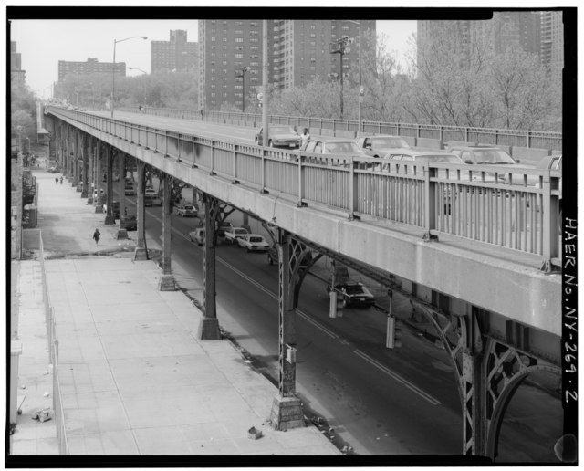
The street consists of upper and lower portions, linked only by a steep pedestrian stairwell. The upper portion starts on the West Side at Riverside Drive, crossing Broadway, Amsterdam Avenue, and St. Nicholas Avenue. At St. Nicholas Place, the terrain drops off steeply, forming Coogan's Bluff. 155th Street is carried on the 1,600-foot (490 m) long 155th Street Viaduct, a City Landmark constructed in 1893, that slopes down towards the Harlem River, continuing onto the Macombs Dam Bridge, crossing over (but not intersecting with) the Harlem River Drive.[2][3] An unconnected lower section of 155th Street runs at ground level under the viaduct, between a dead-end west of Bradhurst Avenue and a service road of the Harlem River Drive.[4]
The New York City Subway serves the upper portion of 155th Street at 155th Street/St. Nicholas Avenue on the IND Eighth Avenue Line and the lower portion at 155th Street/Frederick Douglass Boulevard on the IND Concourse Line.[5]
This section needs additional citations for verification. (December 2023) |
Seamless Wikipedia browsing. On steroids.
Every time you click a link to Wikipedia, Wiktionary or Wikiquote in your browser's search results, it will show the modern Wikiwand interface.
Wikiwand extension is a five stars, simple, with minimum permission required to keep your browsing private, safe and transparent.