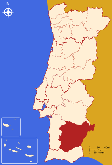
The Comunidade Intermunicipal do Baixo Alentejo (Portuguese pronunciation: [ˈbai̯ʃu ɐlẽˈtɛʒu]; English: Lower Alentejo) is an administrative division in Portugal. It was created in 2009.[1] It is also a NUTS3 subregion of the Alentejo Region.[2] The seat of the intermunicipal community is Beja. Baixo Alentejo comprises 13 of the 14 municipalities of the Beja District. The population in 2011 was 126,692,[3] in an area of 8,542.72 km2.[4]

It is bordered on the North by Alentejo Central Subregion, on the East by Spain, on the South by the Algarve and on the West by Alentejo Litoral. It covers the Eastern part of the former Baixo Alentejo Province.
Municipalities
It is composed of 13 municipalities:[5]
| Municipality | Population (2011)[3] | Area (km2)[4] |
|---|---|---|
| Aljustrel | 9,257 | 458.47 |
| Almodôvar | 7,449 | 777.88 |
| Alvito | 2,504 | 264.85 |
| Barrancos | 1,834 | 168.42 |
| Beja | 35,854 | 1146.44 |
| Castro Verde | 7,276 | 569.44 |
| Cuba | 4,878 | 172.09 |
| Ferreira do Alentejo | 8,255 | 648.25 |
| Mértola | 7,274 | 1292.87 |
| Moura | 15,167 | 958.46 |
| Ourique | 5,389 | 663.31 |
| Serpa | 15,623 | 1105.63 |
| Vidigueira | 5,932 | 316.61 |
| Total | 126,692 | 8,542.72 |
References
External links
Wikiwand in your browser!
Seamless Wikipedia browsing. On steroids.
Every time you click a link to Wikipedia, Wiktionary or Wikiquote in your browser's search results, it will show the modern Wikiwand interface.
Wikiwand extension is a five stars, simple, with minimum permission required to keep your browsing private, safe and transparent.

