Chase Side
From Wikipedia, the free encyclopedia

Chase Side is a road between Cockfosters and Southgate in the London Borough of Enfield. It runs from the junction of Cat Hill, Cockfosters Road and Bramley Road in the north to Southgate Circus in the south and forms part of the boundary with the London Borough of Barnet. Chase Side is named for its former location adjacent to Enfield Chase.[1]


In the north on the east side are the Chicken Shed Theatre and Bramley Sports Ground. Opposite is the Cat Hill Chase Side Pond and one of the entrances to the housing development known as Bolingbroke Park on the former Middlesex University campus site. Mid-way along the road is the former Sir Thomas Lipton Care Home, aka Osidge House, on the west side. At the southern end is St Andrew's church, Southgate and the main Southgate shopping area. The road terminates at Southgate Circus adjacent to Southgate Underground Station.
Gallery
 Sir Thomas Lipton Care Home
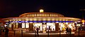 Southgate Underground Station
 Cat Hill Chase Side Pond


References
External links
Wikiwand in your browser!
Seamless Wikipedia browsing. On steroids.
Every time you click a link to Wikipedia, Wiktionary or Wikiquote in your browser's search results, it will show the modern Wikiwand interface.
Wikiwand extension is a five stars, simple, with minimum permission required to keep your browsing private, safe and transparent.