
Châtenay, Isère
Commune in Auvergne-Rhône-Alpes, France / From Wikipedia, the free encyclopedia
Châtenay (French pronunciation: [ʃatnɛ]) is a commune in the Isère department in southeastern France.
Quick Facts Country, Region ...
Châtenay | |
|---|---|
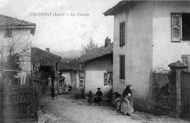 The centre of Châtenay in 1920 | |
Location of Châtenay  | |
 Châtenay  Châtenay | |
| Coordinates: 45°19′18″N 5°13′48″E | |
| Country | France |
| Region | Auvergne-Rhône-Alpes |
| Department | Isère |
| Arrondissement | Vienne |
| Canton | Bièvre |
| Government | |
| • Mayor (2020–2026) | Christian Chevallier[1] |
| Area 1 | 4.62 km2 (1.78 sq mi) |
| Population (2021)[2] | 434 |
| • Density | 94/km2 (240/sq mi) |
| Time zone | UTC+01:00 (CET) |
| • Summer (DST) | UTC+02:00 (CEST) |
| INSEE/Postal code | 38093 /38980 |
| Elevation | 324–548 m (1,063–1,798 ft) (avg. 385 m or 1,263 ft) |
| 1 French Land Register data, which excludes lakes, ponds, glaciers > 1 km2 (0.386 sq mi or 247 acres) and river estuaries. | |
Close