File:50TH_PENNSYLVANIA_VOLUNTEER_INFANTRY_MONUMENT,_EAST_SIDE_RODMAN_AVENUE_-_Antietam_National_Battlefield,_Sharpsburg,_Washington_County,_MD_HABS_MD,22-SHARP.V,9-78.tif
From Wikipedia, the free encyclopedia

Size of this JPG preview of this TIF file: 428 × 599 pixels. Other resolutions: 171 × 240 pixels | 343 × 480 pixels | 549 × 768 pixels | 731 × 1,024 pixels | 1,463 × 2,048 pixels | 3,572 × 5,000 pixels.
Original file (3,572 × 5,000 pixels, file size: 17.04 MB, MIME type: image/tiff)
| This is a file from the Wikimedia Commons. Information from its description page there is shown below. Commons is a freely licensed media file repository. You can help. |
Summary
| General Benjamin C. Christ (1904) by William Clark Noble.50TH PENNSYLVANIA VOLUNTEER INFANTRY MONUMENT, EAST SIDE RODMAN AVENUE - Antietam National Battlefield, Sharpsburg, Washington County, MD | |||||
|---|---|---|---|---|---|
| Title |
General Benjamin C. Christ (1904) by William Clark Noble. 50TH PENNSYLVANIA VOLUNTEER INFANTRY MONUMENT, EAST SIDE RODMAN AVENUE - Antietam National Battlefield, Sharpsburg, Washington County, MD |
||||
| Description |
Mansfield, Joseph K, F; Stetson, John L; Starke, William E; Anderson; Richardson, Israel; McKinley, William; O'Branch, L; Rodman, Isaac; Barton, Clara; Reilly, O T; Boucher, Jack E, photographer; Boucher, Jack E, photographer; Price, Virginia B, transmitter |
||||
| Depicted place | Maryland; Washington County; Sharpsburg | ||||
| Date | Documentation compiled after 1933 | ||||
| Dimensions | 5 x 7 in. | ||||
| Current location |
Library of Congress Prints and Photographs Division Washington, D.C. 20540 USA http://hdl.loc.gov/loc.pnp/pp.print |
||||
| Accession number |
HABS MD,22-SHARP.V,9-78 |
||||
| Credit line |
|
||||
| Notes |
|
||||
| References |
|
||||
| Source | https://www.loc.gov/pictures/item/md1073.photos.085388p | ||||
| Permission (Reusing this file) |
|
||||

| Object location | 39° 27′ 03.5″ N, 77° 44′ 24.3″ W | View this and other nearby images on: OpenStreetMap |
|---|
Captions
Add a one-line explanation of what this file represents
Items portrayed in this file
depicts
39°27'27.0"N, 77°44'57.1"W
39°27'3.499"N, 77°44'24.299"W
image/tiff
60b58bd1503d5568d375b1f66176e4f5c0fa8dfd
17,862,520 byte
5,000 pixel
3,572 pixel
File history
Click on a date/time to view the file as it appeared at that time.
| Date/Time | Thumbnail | Dimensions | User | Comment | |
|---|---|---|---|---|---|
| current | 02:49, 23 July 2014 | 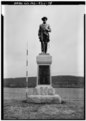 | 3,572 × 5,000 (17.04 MB) | Fæ | GWToolset: Creating mediafile for Fæ. HABS 21 July 2014 (1601:1800) |
File usage
The following pages on the English Wikipedia use this file (pages on other projects are not listed):
Global file usage
The following other wikis use this file:
- Usage on ar.wikipedia.org
- Usage on es.wikipedia.org
- Usage on www.wikidata.org
Metadata
This file contains additional information, probably added from the digital camera or scanner used to create or digitize it.
If the file has been modified from its original state, some details may not fully reflect the modified file.
| Author | Library of Congress |
|---|---|
| Width | 3,572 px |
| Height | 5,000 px |
| Compression scheme | Uncompressed |
| Pixel composition | Black and white (Black is 0) |
| Orientation | Normal |
| Number of components | 1 |
| Number of rows per strip | 18 |
| Horizontal resolution | 700 dpi |
| Vertical resolution | 700 dpi |
| Data arrangement | chunky format |
| File change date and time | 15:33, 2 March 1999 |