File:European_Union_Exclusive_Economic_Zones.PNG
From Wikipedia, the free encyclopedia
Size of this preview: 767 × 600 pixels. Other resolutions: 307 × 240 pixels | 614 × 480 pixels | 982 × 768 pixels | 1,280 × 1,001 pixels | 2,560 × 2,002 pixels | 4,572 × 3,576 pixels.
Original file (4,572 × 3,576 pixels, file size: 1.65 MB, MIME type: image/png)
| This is a file from the Wikimedia Commons. Information from its description page there is shown below. Commons is a freely licensed media file repository. You can help. |
Summary
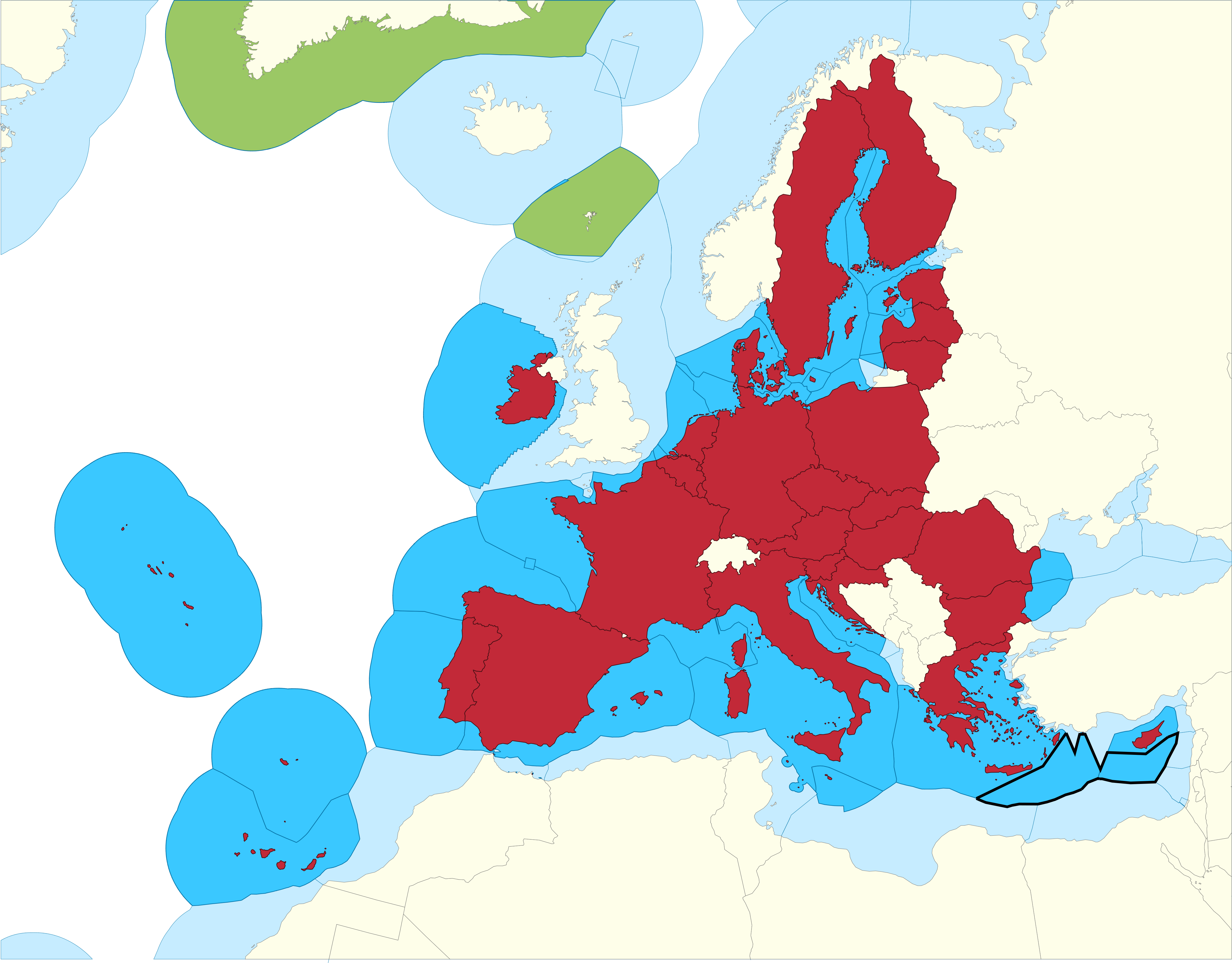
| DescriptionEuropean Union Exclusive Economic Zones.PNG |
English: European Union Member states Exclusive Economic Zones |
|||||
| Date | ||||||
| Source |
|
|||||
| Author | Sette-quattro, replacing the previous work done by Luis_wiki | |||||
| Permission (Reusing this file) |
Own work | |||||
| Other versions |
|


Licensing
| Public domainPublic domainfalsefalse |
| I, the copyright holder of this work, release this work into the public domain. This applies worldwide. In some countries this may not be legally possible; if so: I grant anyone the right to use this work for any purpose, without any conditions, unless such conditions are required by law. |
Captions
Add a one-line explanation of what this file represents
Items portrayed in this file
depicts
8 September 2020
image/png
File history
Click on a date/time to view the file as it appeared at that time.
| Date/Time | Thumbnail | Dimensions | User | Comment | |
|---|---|---|---|---|---|
| current | 11:14, 17 February 2021 | | 4,572 × 3,576 (1.65 MB) | Ahmetlii | higher resolution |
| 11:09, 17 February 2021 |  | 1,280 × 997 (308 KB) | Ahmetlii | added the disputed EEZ border per en:Cyprus–Turkey maritime zones dispute | |
| 21:33, 8 September 2020 |  | 4,572 × 3,566 (1.22 MB) | Sette-quattro | updated without UK, clearer boundaries | |
| 08:54, 16 July 2011 |  | 485 × 294 (86 KB) | Epipelagic | Somewhat simplified the map | |
| 11:12, 23 December 2010 |  | 489 × 298 (19 KB) | Begg maps | {{Information |Description={{es|1=-}} |Source=- |Author=- |Date=- |Permission= |other_versions= }} | |
| 23:31, 27 August 2007 |  | 489 × 298 (19 KB) | Luis wiki | {{Information |Description= European Union Member states Exclusive Economic Zones |Source= Own work over screen capture of Map Interface of VLIZ Maritime Boundaries Geodatabase (http://w2.vliz.be/vmdcdata/marbound/geointerface.php) |Date= 28 August 2007 |
File usage
The following pages on the English Wikipedia use this file (pages on other projects are not listed):
Global file usage
The following other wikis use this file:
- Usage on ar.wikipedia.org
- Usage on ast.wikipedia.org
- Usage on ca.wikipedia.org
- Usage on cs.wikipedia.org
- Usage on es.wikipedia.org
- Usage on eu.wikipedia.org
- Usage on fi.wikipedia.org
- Usage on he.wikipedia.org
- Usage on id.wikipedia.org
- Usage on it.wikipedia.org
- Usage on ja.wikipedia.org
- Usage on ko.wikipedia.org
- Usage on no.wikipedia.org
- Usage on pt.wikipedia.org
- Usage on sv.wikipedia.org
- Usage on uk.wikipedia.org
- Usage on zh.wikipedia.org
Metadata
This file contains additional information, probably added from the digital camera or scanner used to create or digitize it.
If the file has been modified from its original state, some details may not fully reflect the modified file.
| Horizontal resolution | 377.57 dpc |
|---|---|
| Vertical resolution | 377.57 dpc |
| Software used |