File:Karte_Bodensee.png
From Wikipedia, the free encyclopedia
Size of this preview: 800 × 467 pixels. Other resolutions: 320 × 187 pixels | 640 × 373 pixels | 1,181 × 689 pixels.
Original file (1,181 × 689 pixels, file size: 213 KB, MIME type: image/png)
| This is a file from the Wikimedia Commons. Information from its description page there is shown below. Commons is a freely licensed media file repository. You can help. |
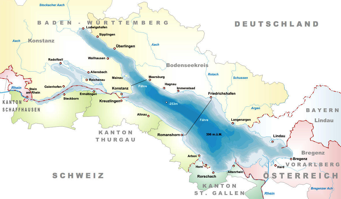
Deutsch: Karte des Bodensee
English: Map of the Lake Constance
Español: Mapa del lago de Constanza
Français : Carte du Lac de Constance
Italiano: Mappa del lago di Costanza
Polski: Mapa Jeziora Bodeńskiego
Русский: Карта Боденского озера
Image History (before Commons @deWP):
- 18:09, 1. Mär 2005 . . Tschubby (288703 Byte) (This Version)
- 11:09, 27. Feb 2005 . . Tschubby (288714 Byte)
- 11:05, 27. Feb 2005 . . Tschubby (288489 Byte)
This Image is Used in:
- The German Wikipedia Image Description Page
- please edit and complete this listening

|
Permission is granted to copy, distribute and/or modify this document under the terms of the GNU Free Documentation License, Version 1.2 or any later version published by the Free Software Foundation; with no Invariant Sections, no Front-Cover Texts, and no Back-Cover Texts. A copy of the license is included in the section entitled GNU Free Documentation License.http://www.gnu.org/copyleft/fdl.htmlGFDLGNU Free Documentation Licensetruetrue |
| This file is licensed under the Creative Commons Attribution-Share Alike 3.0 Unported license. | ||
| ||
| This licensing tag was added to this file as part of the GFDL licensing update.http://creativecommons.org/licenses/by-sa/3.0/CC BY-SA 3.0Creative Commons Attribution-Share Alike 3.0truetrue |
Captions
Add a one-line explanation of what this file represents
Items portrayed in this file
depicts
File history
Click on a date/time to view the file as it appeared at that time.
| Date/Time | Thumbnail | Dimensions | User | Comment | |
|---|---|---|---|---|---|
| current | 18:08, 1 December 2005 | | 1,181 × 689 (213 KB) | Wiki-vr | borders taken away, which were none :-) |
| 14:46, 26 September 2005 |  | 1,181 × 689 (282 KB) | Tschubby | ||
| 18:15, 18 February 2005 |  | 1,181 × 689 (282 KB) | Schaengel89~commonswiki |
File usage
More than 100 pages use this file. The following list shows the first 100 pages that use this file only. A full list is available.
- Aach (Arbon)
- Allensbach
- Alpine Rhine
- Altnau
- Appenzell Alps
- Appenzell Ausserrhoden
- Arbon
- Arbon District
- Arenenberg
- Berlingen, Switzerland
- Bodanrück
- Bodenseekreis
- Bodensee–Toggenburg railway
- Bodman-Ludwigshafen
- Bottighofen
- Bregenz
- Bregenz District
- Bregenzer Ach
- Canton of St. Gallen
- Dornbirner Ach
- Egnach
- Eriskirch
- Ermatingen
- Eschenz
- Ferdinand von Zeppelin
- Frauenfeld District
- Friedrichshafen
- Friedrichshafen Airport
- Fußach
- Gaienhofen
- Gaißau
- Gnadensee
- Goldach
- Gottlieben
- Güttingen
- Hagnau am Bodensee
- Hard, Austria
- Heiden, Switzerland
- Henry Dunant
- High Rhine
- High Rhine Railway
- Horn, Switzerland
- Höchst, Austria
- Hörbranz
- Immenstaad am Bodensee
- Kesswil
- Konstanz
- Konstanz (district)
- Konstanz Minster
- Kressbronn am Bodensee
- Kreuzlingen
- Kreuzlingen District
- Lake Constance
- Lake Line
- Langenargen
- Lindau
- Lindau (district)
- Lochau
- Lutzenberg, Switzerland
- Mainau
- Mammern
- Meersburg
- Meersburg Castle
- Moos, Baden-Württemberg
- Münsterlingen
- Neues Schloss (Meersburg)
- Nonnenhorn
- Petershausen Abbey
- Pfahlbaumuseum Unteruhldingen
- Pfänder
- Radolfzell
- Reichenau Abbey
- Reichenau Island
- Romanshorn
- Rorschach, Switzerland
- Rorschach (Wahlkreis)
- Rorschach–Heiden railway
- Salenstein
- Salmsach
- Schussen
- Seefelder Aach
- Sipplingen
- St. Gallen–Altenrhein Airport
- Steckborn
- Stein am Rhein
- Steinach, St. Gallen
- Stetten, Bodenseekreis
- THURBO
- Thal, St. Gallen
- Thurgau
- Triboltingen
- Tägerwilen
- Uhldingen-Mühlhofen
- Unteruhldingen
- Uttwil
- Vorarlberg
- Walzenhausen
- Wasserburg am Bodensee
- Wolfhalden
- Zeppelin Museum Friedrichshafen
View more links to this file.
Global file usage
The following other wikis use this file:
- Usage on af.wikipedia.org
- Usage on als.wikipedia.org
- Usage on ar.wikipedia.org
- Usage on arz.wikipedia.org
- Usage on be.wikipedia.org
- Usage on br.wikipedia.org
- Usage on bs.wikipedia.org
- Usage on ca.wikipedia.org
- Usage on ceb.wikipedia.org
- Usage on cs.wikipedia.org
- Usage on cu.wikipedia.org
- Usage on cy.wikipedia.org
- Usage on da.wikipedia.org
- Usage on de.wikipedia.org
- Höri (Bodensee)
- Wikipedia:Kandidaten für exzellente Bilder/Archiv2005/3
- Bodanrück
- Benutzer Diskussion:HaSee/A6
- Wikipedia:Kandidaten für exzellente Bilder/Archiv2007/1
- Wikipedia:Grafikwerkstatt/Archiv/2010/April
- Benutzer Diskussion:Tschubby/Archiv 2010
- Dreiländerecke Europas
- Benutzer:Kpfiwa/Dreiländerecke Europas
- Usage on de.wikinews.org
- Usage on de.wiktionary.org
- Usage on el.wikipedia.org
- Usage on es.wikipedia.org
- Usage on eu.wikipedia.org
- Usage on fa.wikipedia.org
- Usage on fo.wikipedia.org
- Usage on fr.wikipedia.org
- Usage on fy.wikipedia.org
- Usage on ga.wikipedia.org
- Usage on gl.wikipedia.org
- Usage on hu.wikipedia.org
- Usage on ia.wikipedia.org
- Usage on incubator.wikimedia.org
- Usage on it.wikipedia.org
- Usage on it.wikivoyage.org
- Usage on ja.wikipedia.org
- Usage on ko.wikipedia.org
- Usage on lb.wikipedia.org
- Usage on lv.wikipedia.org
- Usage on mk.wikipedia.org
- Usage on mn.wikipedia.org
- Usage on mr.wikipedia.org
- Usage on ms.wikipedia.org
- Usage on ne.wikipedia.org
- Usage on nl.wikipedia.org
- Usage on nn.wikipedia.org
- Usage on no.wikipedia.org
View more global usage of this file.
Retrieved from "https://en.wikipedia.org/wiki/File:Karte_Bodensee.png"