File:Lower_Egypt_ancient_nomes_position_map.jpg
From Wikipedia, the free encyclopedia
No higher resolution available.
Lower_Egypt_ancient_nomes_position_map.jpg (564 × 249 pixels, file size: 28 KB, MIME type: image/jpeg)
| This is a file from the Wikimedia Commons. Information from its description page there is shown below. Commons is a freely licensed media file repository. You can help. |
Summary
| DescriptionLower Egypt ancient nomes position map.jpg |
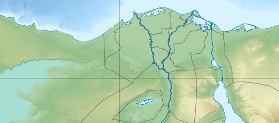
English: Location map of Lower Egypt Topographic scale: 1:4,932,000 (precision: 1,233 m) Equirectangular projection, WGS84 datum *Standard meridian: 030° 45' E *Central parallel: 26° 42' N Geographic limits of the map: * Top: 31° 45' N * Bottom: 29° 00' N * Left: 027° 00' E * Right: 034° 00' E |
| Date | (UTC) |
| Source | |
| Author |
|
| This is a retouched picture, which means that it has been digitally altered from its original version. Modifications: Extracted the Lower Egypt area. The original can be viewed here: Egypt relief location map.jpg:
|
I, the copyright holder of this work, hereby publish it under the following licenses:
This file is licensed under the Creative Commons Attribution-Share Alike 3.0 Unported license.
- You are free:
- to share – to copy, distribute and transmit the work
- to remix – to adapt the work
- Under the following conditions:
- attribution – You must give appropriate credit, provide a link to the license, and indicate if changes were made. You may do so in any reasonable manner, but not in any way that suggests the licensor endorses you or your use.
- share alike – If you remix, transform, or build upon the material, you must distribute your contributions under the same or compatible license as the original.

|
Permission is granted to copy, distribute and/or modify this document under the terms of the GNU Free Documentation License, Version 1.2 or any later version published by the Free Software Foundation; with no Invariant Sections, no Front-Cover Texts, and no Back-Cover Texts. A copy of the license is included in the section entitled GNU Free Documentation License.http://www.gnu.org/copyleft/fdl.htmlGFDLGNU Free Documentation Licensetruetrue |
You may select the license of your choice.
Original upload log
This image is a derivative work of the following images:
- File:Egypt_relief_location_map.jpg licensed with Cc-by-sa-3.0, GFDL
- 2011-04-18T13:59:05Z Sting 1055x975 (424455 Bytes) Updated after Governorats dissolution
- 2010-07-19T13:30:06Z Sting 1055x973 (462160 Bytes) Color profile
- 2010-03-07T19:04:48Z Sting 1055x973 (461278 Bytes) == {{int:filedesc}} == {{Location|26|42|00|N|30|45|00|E|scale:10000000}} {{Information |Description= {{de|Relief Positionskarte von [[:de:Ägypten|Ägypten]]}} {{en|Physical location map of [[:en:Egypt|Egypt]].}} {{fr|Carte
Uploaded with derivativeFX
Captions
Add a one-line explanation of what this file represents
Items portrayed in this file
depicts
19 June 2011
File history
Click on a date/time to view the file as it appeared at that time.
| Date/Time | Thumbnail | Dimensions | User | Comment | |
|---|---|---|---|---|---|
| current | 20:31, 19 June 2011 | | 564 × 249 (28 KB) | Bogomolov.PL | {{Information |Description={{en|Location map of Lower Egypt <br/> Topographic scale: 1:4,932,000 (precision: 1,233 m)<br/> Equirectangular projection, WGS84 datum<br/> *Standard meridian: 030° 45' E<br/> *Central parallel: 26° 42' N |
File usage
The following pages on the English Wikipedia use this file (pages on other projects are not listed):
- Battle of Heliopolis
- Battle of the Nile
- El Kurdi
- Environmental issues in Egypt
- Fatimid conquest of Egypt
- Fatimid invasion of Egypt (914–915)
- Fatimid invasion of Egypt (919–921)
- Haïm Capoussi Synagogue
- Headless Pyramid
- Lepsius L
- Pyramid of Djedkare Isesi
- Pyramid of Djoser
- Pyramid of Neferefre
- Pyramid of Neferirkare
- Pyramid of Nyuserre
- Pyramid of Pepi I
- Pyramid of Sahure
- Pyramid of Unas
- Suez
- Unfinished Pyramid of Abusir
- User:Archaeobuf/sandbox/hyksos
- User:Maggie39/sandbox
- Module:Location map/data/Lower Egypt
- Module:Location map/data/Lower Egypt/doc
Global file usage
The following other wikis use this file:
- Usage on azb.wikipedia.org
- Usage on bh.wikipedia.org
- Usage on bn.wikipedia.org
- Usage on es.wikipedia.org
- Usage on fa.wikipedia.org
- Usage on id.wikipedia.org
- Usage on ja.wikipedia.org
- Usage on la.wikipedia.org
- Usage on ru.wikipedia.org
- Usage on sco.wikipedia.org
- Usage on si.wikipedia.org
- Usage on th.wikipedia.org
- Usage on ur.wikipedia.org
View more global usage of this file.
Metadata
This file contains additional information, probably added from the digital camera or scanner used to create or digitize it.
If the file has been modified from its original state, some details may not fully reflect the modified file.
| _error | 0 |
|---|