File:Roman_Empire_Map.png
From Wikipedia, the free encyclopedia
No higher resolution available.
Roman_Empire_Map.png (800 × 548 pixels, file size: 44 KB, MIME type: image/png)
| This is a file from the Wikimedia Commons. Information from its description page there is shown below. Commons is a freely licensed media file repository. You can help. |
Summary
| DescriptionRoman Empire Map.png |
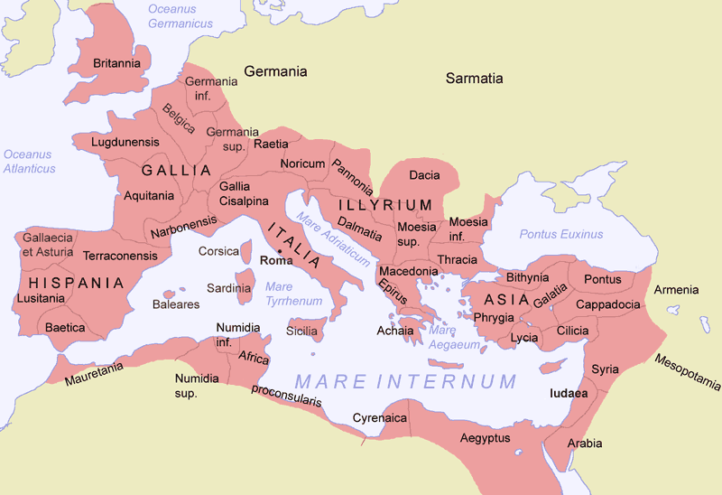
Deutsch: Römisches Reich um 117 zur Zeit Trajans
English: Roman empire around 117 AD.
Español: El Imperio Romano en su máxima extensión, durante el reinado de Trajano (hacia el 117)
Suomi: Rooman valtakunta |
||
| Date | |||
| Source |
Own work
|
||
| Author | Jani Niemenmaa | ||
| Other versions |
|
Licensing

|
Permission is granted to copy, distribute and/or modify this document under the terms of the GNU Free Documentation License, Version 1.2 or any later version published by the Free Software Foundation; with no Invariant Sections, no Front-Cover Texts, and no Back-Cover Texts. A copy of the license is included in the section entitled GNU Free Documentation License.http://www.gnu.org/copyleft/fdl.htmlGFDLGNU Free Documentation Licensetruetrue |
| This file is licensed under the Creative Commons Attribution-Share Alike 3.0 Unported license. | ||
| ||
| This licensing tag was added to this file as part of the GFDL licensing update.http://creativecommons.org/licenses/by-sa/3.0/CC BY-SA 3.0Creative Commons Attribution-Share Alike 3.0truetrue |
Captions
Add a one-line explanation of what this file represents
Karttakuva Rooman valtakunnasta suurimmillaan vuonna 117.
Items portrayed in this file
depicts
2004
image/png
File history
Click on a date/time to view the file as it appeared at that time.
| Date/Time | Thumbnail | Dimensions | User | Comment | |
|---|---|---|---|---|---|
| current | 15:11, 4 February 2012 | | 800 × 548 (44 KB) | AnonMoos | change "Palestina"[sic] to "Iudaea" -- term "Palaestina" did not come into official use until ca. 135 AD |
| 23:40, 17 July 2007 |  | 800 × 548 (45 KB) | ARTE | removed watermark | |
| 16:22, 10 January 2005 |  | 800 × 548 (69 KB) | Jniemenmaa | {{GFDL}} |
File usage
The following pages on the English Wikipedia use this file (pages on other projects are not listed):
Global file usage
The following other wikis use this file:
- Usage on als.wikipedia.org
- Usage on ar.wikipedia.org
- Usage on ast.wikipedia.org
- Usage on bat-smg.wikipedia.org
- Usage on ba.wikipedia.org
- Usage on be.wikipedia.org
- Usage on bg.wikipedia.org
- Usage on bn.wikibooks.org
- Usage on br.wikipedia.org
- Usage on ca.wikipedia.org
- Usage on co.wikipedia.org
- Usage on cs.wikipedia.org
- Usage on cv.wikipedia.org
- Usage on cy.wikipedia.org
- Usage on da.wikipedia.org
- Usage on de.wikipedia.org
- Usage on de.wiktionary.org
- Usage on dsb.wikipedia.org
- Usage on el.wikipedia.org
- Usage on en.wikibooks.org
- Usage on en.wiktionary.org
- Usage on eo.wikipedia.org
- Usage on es.wikipedia.org
- Usage on es.wikiversity.org
- Usage on et.wikipedia.org
View more global usage of this file.
Retrieved from "https://en.wikipedia.org/wiki/File:Roman_Empire_Map.png"