File:Somaliland.png
From Wikipedia, the free encyclopedia
Size of this preview: 800 × 504 pixels. Other resolutions: 320 × 202 pixels | 640 × 403 pixels | 1,024 × 645 pixels | 1,280 × 806 pixels | 1,815 × 1,143 pixels.
Original file (1,815 × 1,143 pixels, file size: 2.6 MB, MIME type: image/png)
| This is a file from the Wikimedia Commons. Information from its description page there is shown below. Commons is a freely licensed media file repository. You can help. |
Summary
| DescriptionSomaliland.png |
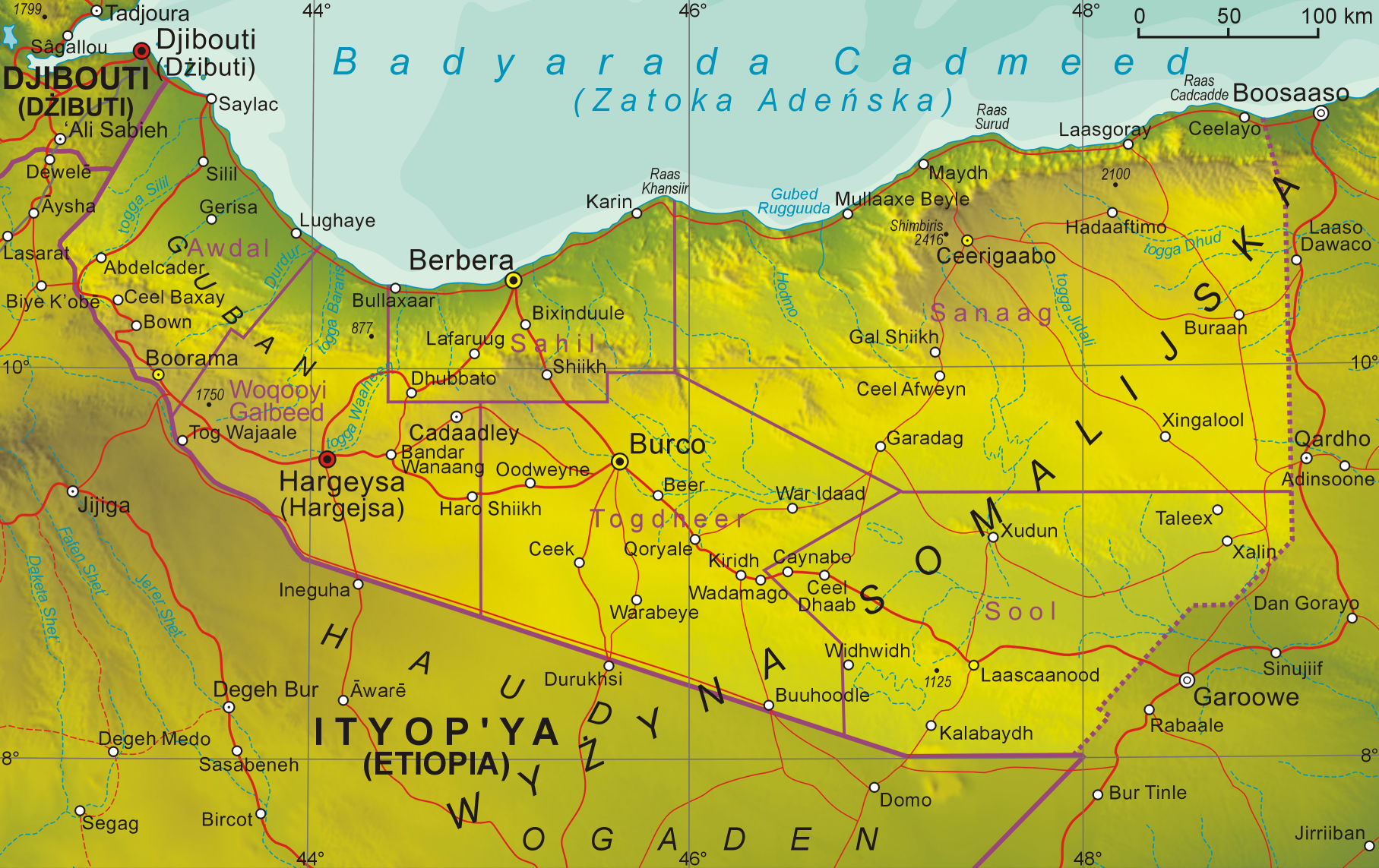
English: Map of Somaliland
Polski: Mapa Somalilandu |
| Date | 12.10.2008 |
| Source | Own work |
| Author | Aotearoa |
Licensing
I, the copyright holder of this work, hereby publish it under the following license:

|
Permission is granted to copy, distribute and/or modify this document under the terms of the GNU Free Documentation License, Version 1.2 or any later version published by the Free Software Foundation; with no Invariant Sections, no Front-Cover Texts, and no Back-Cover Texts. A copy of the license is included in the section entitled GNU Free Documentation License.http://www.gnu.org/copyleft/fdl.htmlGFDLGNU Free Documentation Licensetruetrue |
| This file is licensed under the Creative Commons Attribution-Share Alike 3.0 Unported license. | ||
| ||
| This licensing tag was added to this file as part of the GFDL licensing update.http://creativecommons.org/licenses/by-sa/3.0/CC BY-SA 3.0Creative Commons Attribution-Share Alike 3.0truetrue |
Captions
Add a one-line explanation of what this file represents
Items portrayed in this file
depicts
File history
Click on a date/time to view the file as it appeared at that time.
| Date/Time | Thumbnail | Dimensions | User | Comment | |
|---|---|---|---|---|---|
| current | 17:57, 20 June 2020 | | 1,815 × 1,143 (2.6 MB) | Kzl55 | Reverted to version as of 08:20, 1 November 2008 (UTC) Irrelevant, map is about claimed territory. |
| 18:35, 16 June 2020 |  | 800 × 504 (724 KB) | Meelpringthusss | added disputed region | |
| 08:20, 1 November 2008 |  | 1,815 × 1,143 (2.6 MB) | Aotearoa | {{Information |Description= |Source= |Date= |Author= |Permission= |other_versions= }} | |
| 08:55, 12 October 2008 |  | 1,360 × 854 (1.65 MB) | Aotearoa | {{Information |Description={{en|1=Map of Somaliland}} {{pl|1=Mapa Somalilandu}} |Source=Praca własna osoby przesyłającej (own work by uploader) |Author=Aotearoa |Date=12.10.2008 |Permission= |other_versions= }} <!--{{ImageUpload|full |
File usage
The following pages on the English Wikipedia use this file (pages on other projects are not listed):
Global file usage
The following other wikis use this file:
- Usage on en.wikibooks.org
- Usage on os.wikipedia.org
- Usage on pl.wikipedia.org
Metadata
This file contains additional information, probably added from the digital camera or scanner used to create or digitize it.
If the file has been modified from its original state, some details may not fully reflect the modified file.
| PNG file comment | |
|---|---|
| Horizontal resolution | 236.22 dpc |
| Vertical resolution | 236.22 dpc |
Retrieved from "https://en.wikipedia.org/wiki/File:Somaliland.png"