Franklin County, Georgia
County in Georgia, United States / From Wikipedia, the free encyclopedia
Dear Wikiwand AI, let's keep it short by simply answering these key questions:
Can you list the top facts and stats about Franklin County, Georgia?
Summarize this article for a 10 year old
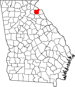
Franklin County is a county located in the northeastern part of the U.S. state of Georgia. As of the 2020 census, the population was 23,424.[1] The county seat is Carnesville.[2] On February 25, 1784, Franklin and Washington became Georgia's eighth and ninth counties,[3] with Franklin named in honor of patriot Benjamin Franklin.[4]
Franklin County | |
|---|---|
 Franklin County Courthouse in Carnesville | |
 Location within the U.S. state of Georgia | |
 Georgia's location within the U.S. | |
| Coordinates: 34°22′N 83°14′W | |
| Country | |
| State | |
| Founded | February 25, 1784; 240 years ago (1784) |
| Named for | Benjamin Franklin |
| Seat | Carnesville |
| Largest city | Lavonia |
| Area | |
| • Total | 266 sq mi (690 km2) |
| • Land | 261 sq mi (680 km2) |
| • Water | 5.0 sq mi (13 km2) 1.15% |
| Population (2020) | |
| • Total | 23,424 |
| • Density | 90/sq mi (30/km2) |
| Time zone | UTC−5 (Eastern) |
| • Summer (DST) | UTC−4 (EDT) |
| Congressional district | 9th |
| Website | www |
In its original form, Franklin County included all of the territory now in Banks, Barrow, Clarke, Jackson, Oconee, and Stephens counties, and parts of the modern-day Gwinnett, Hall, Hart, and Madison counties, as well as three counties that are now part of South Carolina. Franklin County has several miles of shoreline on Lake Hartwell.