Langelsheim
Place in Lower Saxony, Germany From Wikipedia, the free encyclopedia
Place in Lower Saxony, Germany From Wikipedia, the free encyclopedia
Langelsheim is a town in the district of Goslar in Lower Saxony, Germany.
Langelsheim | |
|---|---|
 Coat of arms | |
Location of Langelsheim within Goslar district 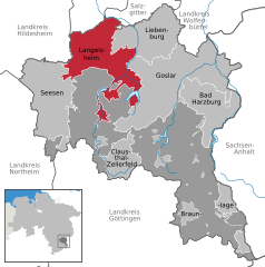 | |
 Langelsheim  Langelsheim | |
| Coordinates: 51°56′17″N 10°20′06″E | |
| Country | Germany |
| State | Lower Saxony |
| District | Goslar |
| Subdivisions | 8 Ortschaften |
| Government | |
| • Mayor (2021–26) | Ingo Henze[1] (SPD) |
| Area | |
| • Total | 108.77 km2 (42.00 sq mi) |
| Elevation | 204 m (669 ft) |
| Population (2022-12-31)[2] | |
| • Total | 15,043 |
| • Density | 140/km2 (360/sq mi) |
| Time zone | UTC+01:00 (CET) |
| • Summer (DST) | UTC+02:00 (CEST) |
| Postal codes | 38685 |
| Dialling codes | 05326 |
| Vehicle registration | GS |
| Website | www |
The municipality is situated between the river Innerste and its tributary the river Grane, on the northern edge of the Harz mountain range and the Harz National Park, located about 8 km (5.0 mi) northwest of Goslar.
Langelsheim is divided into eight Ortschaften[3] with the following population as of 30 June 2020:[4]
The place once called Langenizze developed in the 10th century out of a hill fort at the Kahnstein mountain, erected by the Ottonian dynasty. Langelsheim was the site of historic ironworks, first documented in the 13th century, where ore from the Mines of Rammelsberg was smelted. The former municipalities Hahausen, Lutter am Barenberge and Wallmoden are part of Langelsheim since 1 November 2021.[5]
As of 30 June 2020 there were 11,305 inhabitants in Langelsheim.[4]

|
|
|
|

2006 local elections:
2016 local elections:
SPD: 12 FDP: 1 WGL: 6 CDU: 7
Langelsheim is twinned with:

Seamless Wikipedia browsing. On steroids.
Every time you click a link to Wikipedia, Wiktionary or Wikiquote in your browser's search results, it will show the modern Wikiwand interface.
Wikiwand extension is a five stars, simple, with minimum permission required to keep your browsing private, safe and transparent.
