| Name |
Location |
Date Listed |
Grid Ref. [note 1] |
Geo-coordinates |
Notes |
LB Number [note 2] |
Image |
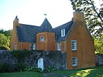
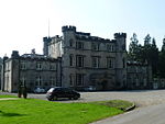
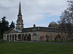
| Preston Hall Stables |
Preston Hall Policies, Pathhead |
|
NT3962865930 |
55°52′58″N 2°58′00″W |
Late-18th-century stable block including kennels, piggery, pheasantry and cottages[5] |
113 |

Upload Photo
|
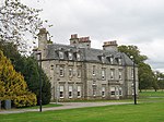
| Whitehill House |
Rosewell |
|
NT2964062010 |
55°50′46″N 3°07′31″W |
19th-century country house by William Burn, later St Joseph's Institution[6] |
687 |
Upload Photo
|
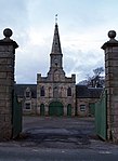
| Preston Hall, North Gate |
Preston Hall Policies, Pathhead |
|
NT4027767156 |
55°53′38″N 2°57′24″W |
18th-century estate gateway[7] |
745 |
Upload Photo
|
| Preston Hall, The Lion's Gate |
Preston Hall Policies, Pathhead |
|
NT3925265209 |
55°52′34″N 2°58′21″W |
Late-18th-century gates and lodges[8] |
746
|  Upload another image
See more images
|
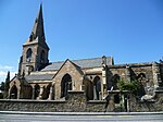
| Crichton Parish Church |
Crichton |
|
NT3808261614 |
55°50′37″N 2°59′25″W |
15th-century former collegiate church of S.S. Mary and Kentigern, including graveyard[9] |
753
|  Upload another image
See more images
|
| Ford House |
Ford, Pathhead |
|
NT3893564359 |
55°52′07″N 2°58′39″W |
17th-century laird's house[10] |
756
|  Upload another image
See more images
|
| Crichton House |
Crichton |
|
NT4003562476 |
55°51′06″N 2°57′34″W |
17th-century laird's house[11] |
757
|  Upload another image
|
| Oxenfoord Castle |
Pathhead |
|
NT3881665507 |
55°52′44″N 2°58′46″W |
18th-century country house by Robert Adam[12] |
768
|  Upload another image
See more images
|
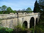
| Oxenfoord Viaduct |
Pathhead |
|
NT3882265580 |
55°52′46″N 2°58′46″W |
18th-century bridge accessing Oxenfoord Castle[13] |
769
|  Upload another image
See more images
|
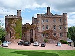
| Preston Hall |
Pathhead |
|
NT3943165760 |
55°52′52″N 2°58′11″W |
Late-18th-century country house by Robert Mitchell[14] |
775
|  Upload another image
See more images
|
| Preston Hall, Walled Garden |
Preston Hall Policies, Pathhead |
|
NT3924265952 |
55°52′58″N 2°58′22″W |
Walled garden including sheds, gazebos, glass houses, sundial and gardener's house[15] |
777 |
Upload Photo
|
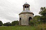
| Preston Hall, The Temple |
Preston Hall Policies, Pathhead |
|
NT3950366419 |
55°53′14″N 2°58′07″W |
Classical temple folly[16] |
779
|  Upload another image
|
| Cockpen and Carrington Parish Church |
Bonnyrigg |
|
NT3193364195 |
55°51′58″N 3°05′21″W |
19th-century church by Archibald Elliot[17] |
780
|  Upload another image
See more images
|
| Dalhousie Castle |
Bonnyrigg |
|
NT3234563595 |
55°51′39″N 3°04′57″W |
15th-century castle, extended in the 19th century by William Burn[18] |
784
|  Upload another image
See more images
|
| Vogrie House |
Newlandrig, Pathhead |
|
NT3808663236 |
55°51′30″N 2°59′26″W |
19th-century country house[19] |
799
|  Upload another image
See more images
|
| Borthwick Castle |
Borthwick |
|
NT3699059732 |
55°49′36″N 3°00′26″W |
15th-century tower house[20] |
805
|  Upload another image
See more images
|
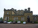
| Middleton Hall |
North Middleton |
|
NT3680558261 |
55°48′48″N 3°00′36″W |
Early-18th-century country house[21] |
806 |
Upload Photo
|
| Arniston House |
Temple |
|
NT3258959467 |
55°49′25″N 3°04′39″W |
[22] |
808
|  Upload another image
See more images
|
| Arniston House, Grotto |
Temple |
|
NT3239959186 |
55°49′16″N 3°04′50″W |
18th-century country house by William Adam[23] |
811 |
Upload Photo
|
| Arniston House, North Gate-Lodge and Elephant Gates |
Temple |
|
NT3366761215 |
55°50′22″N 3°03′39″W |
18th-century gates and lodges[24] |
814 |
Upload Photo
|
| Dalkeith House, Conservatory |
Dalkeith |
|
NT3381868175 |
55°54′08″N 3°03′36″W |
19th-century conservatory by William Burn[25] |
1410
|  Upload another image
See more images
|
| Dalkeith House |
Dalkeith |
|
NT3332567905 |
55°53′59″N 3°04′04″W |
Early-18th-century country house by James Smith[26] |
1411
|  Upload another image
See more images
|
| Dalkeith House, Dark Walk Gateway |
Dalkeith |
|
NT3384067660 |
55°53′51″N 3°03′34″W |
18th-century gateway[27] |
1412
|  Upload another image
See more images
|
| Dalkeith House, King's Gate |
Dalkeith |
|
NT3219267700 |
55°53′51″N 3°05′09″W |
19th-century gateway and lodge by David Bryce and William Burn[28] |
1437
|  Upload another image
|
| Dalkeith House, Montagu Bridge |
Dalkeith |
|
NT3336368120 |
55°54′06″N 3°04′02″W |
18th-century bridge by Robert Adam[29] |
1440
|  Upload another image
See more images
|
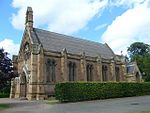
| St Mary's Episcopal Church, Dalkeith |
Musselburgh Road, Dalkeith |
|
NT3348967727 |
55°53′53″N 3°03′55″W |
19th-century Gothic church by David Bryce and William Burn[30] |
1441
|  Upload another image
See more images
|
| Dalkeith House, Stables and Coach House |
Dalkeith |
|
NT3377968134 |
55°54′06″N 3°03′38″W |
18th-century stable block by William Adam[31] |
1442 |
Upload Photo
|
| Glenesk Railway Viaduct |
Eskbank |
|
NT3237267136 |
55°53′33″N 3°04′58″W |
19th-century bridge carrying the Edinburgh and Dalkeith Railway over the River North Esk[32] |
1445 |
Upload Photo
|
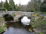
| Lothian Bridge |
Pathhead |
|
NT3910064527 |
55°52′12″N 2°58′29″W |
19th-century bridge by Thomas Telford, carrying the A68 road over the Tyne Water[33] |
5090
|  Upload another image
See more images
|
| Mavisbank House, Dovecot |
Loanhead |
|
NT2939265742 |
55°52′47″N 3°07′49″W |
18th-century circular doocot[34] |
7386
|  Upload another image
|
| Mavisbank House, Gazebo |
Loanhead |
|
NT2886864916 |
55°52′20″N 3°08′18″W |
18th-century garden building[35] |
7387 |
Upload Photo
|
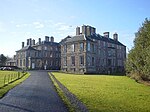
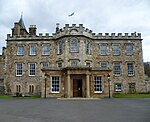
| Melville Castle |
Lasswade |
|
NT3103066981 |
55°53′28″N 3°06′16″W |
18th-century Gothic house by James Playfair[36] |
7394
|  Upload another image
See more images
|
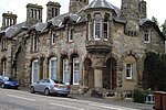
| Barony House |
Wadingburn Road, Lasswade |
|
NT2970065910 |
55°52′52″N 3°07′31″W |
Late-18th-century cottage, remodelled by John Clerk of Eldin[37] |
7398 |
Upload Photo
|
| Mavisbank House |
Loanhead |
|
NT2880765146 |
55°52′27″N 3°08′22″W |
18th-century country house by William Adam and Sir John Clerk of Penicuik[38] |
7404
|  Upload another image
See more images
|
| Glencorse Old Parish Church |
Glencorse, Penicuik |
|
NT2451863038 |
55°51′17″N 3°12′26″W |
17th-century church, now roofless[39] |
7454
|  Upload another image
|
| Glencorse Parish Church |
Glencorse, Penicuik |
|
NT2466762616 |
55°51′03″N 3°12′17″W |
19th-century church by Robert Rowand Anderson[40] |
7456
|  Upload another image
See more images
|
| Bush House |
Bush, Penicuik |
|
NT2457863534 |
55°51′33″N 3°12′23″W |
18th-century house by the Adam Brothers[41] |
7462
|  Upload another image
See more images
|
| Melville Castle, Willie's Temple |
Lasswade |
|
NT3053966850 |
55°53′23″N 3°06′44″W |
18th-century folly[42] |
12940 |
Upload Photo
|
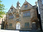
| Hawthornden Castle |
Rosewell, Midlothian |
|
NT2862063677 |
55°51′39″N 3°08′31″W |
Castle, largely of the 17th century, partly restored[43] |
13023
|  Upload another image
See more images
|
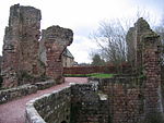
| Roslin Castle |
Roslin |
|
NT2747562763 |
55°51′09″N 3°09′36″W |
Ruined 15th-century defences, with 17th-century house[44] |
13026
|  Upload another image
See more images
|
| Rosslyn Chapel |
Roslin |
|
NT2748963073 |
55°51′19″N 3°09′36″W |
15th-century collegiate chapel[45] |
13028
|  Upload another image
See more images
|
| Auchendinny House |
Auchendinny |
|
NT2517261336 |
55°50′22″N 3°11′47″W |
Early-18th-century house by Sir William Bruce[46] |
13034 |
Upload Photo
|
| Bilston Viaduct |
Loanhead |
|
NT2807364861 |
55°52′17″N 3°09′04″W |
19th-century viaduct for the Edinburgh, Loanhead and Roslin Railway, over the Bilston Burn[47] |
13035
|  Upload another image
See more images
|
| Woolmet House, Gateway |
Danderhall |
|
NT3071569917 |
55°55′02″N 3°06′36″W |
17th-century gateway of demolished Woolmet House, now part of Danderhall Miners' Club[48] |
14184
|  Upload another image
|
| Newbattle Abbey |
Newbattle |
|
NT3334966021 |
55°52′58″N 3°04′01″W |
16th-century house, later extended, on site of a 12th-century Cistercian monastery[49] |
14561
|  Upload another image
See more images
|
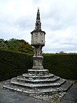
| Newbattle Abbey, North Sundial |
Newbattle |
|
NT3340366084 |
55°53′00″N 3°03′58″W |
17th-century sundial, one of a pair with the South Sundial[50] |
14562
|  Upload another image
|
| Newbattle Abbey, South Sundial |
Newbattle |
|
NT3343566019 |
55°52′58″N 3°03′56″W |
17th-century sundial, one of a pair with the North Sundial[51] |
14563
|  Upload another image
|
| Newbattle Abbey, Maiden Bridge |
Newbattle |
|
NT3367366590 |
55°53′16″N 3°03′43″W |
15th-century bridge over the River South Esk[52] |
14564
|  Upload another image
See more images
|
| Newbattle Abbey, Monkland Wall |
Newbattle |
|
NT3311465839 |
55°52′52″N 3°04′15″W |
Medieval boundary wall[53] |
14566
|  Upload another image
|
| Newbattle Abbey, Port Gate-Lodges and Gates |
Newbattle |
|
NT3311565881 |
55°52′53″N 3°04′15″W |
Early-18th-century gateway and lodges[54] |
14567
|  Upload another image
|
| Newbattle Old Bridge |
Newbattle Road, Newbattle |
|
NT3314465712 |
55°52′48″N 3°04′13″W |
16th-century road bridge[55] |
14568
|  Upload another image
|
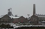
| Lady Victoria Colliery |
Newtongrange |
|
NT3326263693 |
55°51′42″N 3°04′04″W |
Late 19th to mid-20th century, now the Scottish Mining Museum[56] |
14604
|  Upload another image
See more images
|
| Arniston House, Walled Garden |
Gorebridge |
|
NT3252759109 |
55°49′14″N 3°04′42″W |
18th-century walled garden[57] |
14625 |
Upload Photo
|
| Rosebery Home Farm |
Temple |
|
NT3025857458 |
55°48′19″N 3°06′51″W |
Early-19th-century Gothic farm[58] |
14630
|  Upload another image
See more images
|
| Penicuik House |
Penicuik |
|
NT2172659208 |
55°49′11″N 3°15′03″W |
Shell of 18th-century country house by Sir James Clerk, 3rd Baronet, burned out in 1899, currently under major restoration[59] |
14634
|  Upload another image
See more images
|
| New Penicuik House |
Penicuik |
|
NT2168859366 |
55°49′16″N 3°15′05″W |
Former stable block, converted after the main house burned out in 1899[60] |
14635
|  Upload another image
See more images
|
| Fairfield House hot house |
Croft Street, Dalkeith |
|
NT3321167040 |
55°53′31″N 3°04′10″W |
Early- to mid-19th-century glasshouse[61] |
24339 |
Upload Photo
|
| St David's RC Church |
Eskbank Road, Dalkeith |
|
NT3282266921 |
55°53′27″N 3°04′32″W |
Mid-19th-century gothic church[62] |
24355
|  Upload another image
See more images
|
| Eskbank House |
14 Glenesk Crescent, Dalkeith |
|
NT3255966872 |
55°53′25″N 3°04′47″W |
18th-century villa[63] |
24375 |
Upload Photo
|
| Dalkeith Old Kirk |
High Street, Dalkeith |
|
NT3325867442 |
55°53′44″N 3°04′08″W |
15th century, remodelled by David Bryce, includes watch house in graveyard[64] |
24377
|  Upload another image
See more images
|
| Dalkeith Tolbooth |
176-180 High Street, Dalkeith |
|
NT3332367436 |
55°53′43″N 3°04′04″W |
18th-century town hall[65] |
24417
|  Upload another image
See more images
|
| Dalkeith Corn Exchange |
200 High Street And 61 St Andrew Street, Dalkeith |
|
NT3339967526 |
55°53′46″N 3°04′00″W |
Mid-19th-century hall by David Cousin[66] |
24422
|  Upload another image
See more images
|
| Linsandel House |
12 Melville Road, Dalkeith |
|
NT3246366773 |
55°53′22″N 3°04′53″W |
19th-century Italianate villa[67] |
24443 |
Upload Photo
|
| Dalkeith Lodge (Newbattle Abbey West Lodge) |
Newmills Road, Dalkeith |
|
NT3337967047 |
55°53′31″N 3°04′00″W |
Mid-19th-century Gothic gateway and lodge[68] |
24452 |
Upload Photo
|
| 22-34 Bridge Street and 1-7 Park End |
Penicuik |
|
NT2356559726 |
55°49′29″N 3°13′18″W |
19th-century Gothic shops and tenements by F T Pilkington[69] |
39294
|  Upload another image
|
| Penicuik South Church |
Peebles Road, Penicuik |
|
NT2357959504 |
55°49′22″N 3°13′17″W |
19th-century Gothic church by F T Pilkington[70] |
39295
|  Upload another image
See more images
|
| Mavisbank House, Walled Garden |
Loanhead |
|
NT2893565072 |
55°52′25″N 3°08′14″W |
18th-century walled garden[71] |
44166 |
Upload Photo
|
| Glencorse Barracks Clock Tower |
Glencorse, Penicuik |
|
NT2474861993 |
55°50′43″N 3°12′12″W |
Early-19th-century clock tower and prison[72] |
44614 |
Upload Photo |


.jpg)

.jpg)


.jpg)


.jpg)


.jpg)

.jpg)
.jpg)
.jpg)


