
Mount Himekami
From Wikipedia, the free encyclopedia
Mount Himekami (Japanese: 姫神山, Himekami-san) is a mountain in Morioka, Iwate Prefecture, Japan.[1][2] It lends its name to the band Himekami.[3] Mt. Himekami is about 20 kilometres (12 mi) north of urban Morioka and features alpine flora and views of Mount Iwate. A relatively easy hike to its summit is practicable from April to November.
 Seen from the WNW
 Seen from the west. Taken from Mount Iwate
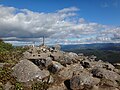 The top of Mount Himekami
.JPG)


Quick Facts Highest point, Elevation ...
| Mount Himekami | |
|---|---|
 Seen from the NbE. | |
| Highest point | |
| Elevation | 1,124 m (3,688 ft) |
| Coordinates | 39°54′59.91″N 141°12′56.8″E |
| Naming | |
| Native name | 姫神山 (Japanese) |
| Geography | |
 Mount Himekami | |
| Climbing | |
| Access | Hiking |
Close