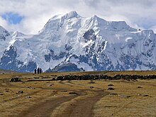
Callangate
Mountain in Peru From Wikipedia, the free encyclopedia
Callangate or Ccallangate is a mountain massif in the Vilcanota mountain range of the Andes in Peru.[3][4] Its highest point is Collpa Ananta[5][6][7] (possibly from Aymara and Quechua qullpa, "saltpeter"),[8][9] also known as Chimboya, with an elevation of 6,110 metres (20,046 ft).[4][5] Another peak in the massif is called Ccallangate.[5] It lies in the Cusco Region, Quispicanchi Province, Ocongate District.[7][6] Collpa Ananta is the second-highest peak in Cusco, and ranks as the 24th highest in Peru.[10][11]
| Callangate | |
|---|---|
 | |
| Highest point | |
| Elevation | 6,110 m (20,050 ft) |
| Prominence | 1,403 m (4,603 ft)[1] |
| Parent peak | Ausangate |
| Coordinates | 13°43′53″S 71°09′36″W |
| Geography | |
| Location | Cusco Region, Peru |
| Parent range | Andes, Vilcanota |
| Climbing | |
| First ascent | 30 July 1957, Günther Hauser, Bernhard Kuhn (Germany)[2] |
First ascent
Callangate was first climbed by Germans Günther Hauser and Bernhard Kuhn on 30 July 1957.[2]
Elevation
Other data from available digital elevation models: SRTM 6104 metres.[12] The height of the nearest key col is 4707 meters, leading to a topographic prominence of 1403 meters.[13] Callangate is considered a Mountain Subrange according to the Dominance System [14] and its dominance is 22.96%. Its parent peak is Ausangate and the Topographic isolation is 9.7 kilometers.[13]
See also
References
External links
Wikiwand in your browser!
Seamless Wikipedia browsing. On steroids.
Every time you click a link to Wikipedia, Wiktionary or Wikiquote in your browser's search results, it will show the modern Wikiwand interface.
Wikiwand extension is a five stars, simple, with minimum permission required to keep your browsing private, safe and transparent.

