Loading AI tools
Ile aux Souris is an island in Seychelles, lying in the eastern shores of Mahe.
Native name: Ile aux Souris Nickname: Rat Island | |
|---|---|
 Souris Island | |
| Geography | |
| Location | Seychelles, Indian Ocean |
| Coordinates | 4°37′S 55°30′E |
| Archipelago | Inner Islands, Seychelles |
| Adjacent to | Indian Ocean |
| Total islands | 1 |
| Major islands |
|
| Area | 0.005 km2 (0.0019 sq mi) |
| Length | 0.1 km (0.06 mi) |
| Width | 0.1 km (0.06 mi) |
| Coastline | 0.25 km (0.155 mi) |
| Highest elevation | 14 m (46 ft) |
| Highest point | Souris |
| Administration | |
| Group | Granitic Seychelles |
| Sub-Group | Mahe Islands |
| Districts | Anse Royale |
| Demographics | |
| Population | 0 (2014) |
| Pop. density | 0/km2 (0/sq mi) |
| Ethnic groups | Creole, French, East Africans, Indians. |
| Additional information | |
| Time zone | |
| ISO code | SC-05 |
| Official website | www |
With a 14-metre elevation ‘it stands just inside the long line of coral reef fringing the coasts of Anse Royale and Anse Bougainville. It is rocky, about 500 metres south west of Pointe au Sel. In the vicinity you can find the Seychelles university.
The island belongs to Anse Royale District.[1]
 Map 1
Map 1 District Map
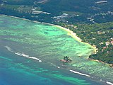 Souris Island in front of the University of Mahe


Wikiwand in your browser!
Seamless Wikipedia browsing. On steroids.
Every time you click a link to Wikipedia, Wiktionary or Wikiquote in your browser's search results, it will show the modern Wikiwand interface.
Wikiwand extension is a five stars, simple, with minimum permission required to keep your browsing private, safe and transparent.