Top Qs
Timeline
Chat
Perspective
Swat District
District in Khyber Pakhtunkhwa, Pakistan From Wikipedia, the free encyclopedia

Remove ads
Swat District (Urdu: ضلع سوات), also known as the Swat Valley, is a district in the Malakand Division of Khyber Pakhtunkhwa, Pakistan. Known for its stunning natural beauty, the district is a popular tourist destination. With a population of 2,687,384 per the 2023 national census, Swat is the 15th-largest district of Khyber Pakhtunkhwa.


Swat District is centred on the Valley of Swat, usually referred to simply as Swat, which is a natural geographic region surrounding the Swat River. The valley was a major centre of early Buddhism of the ancient civilisation of Gandhara, mainly Gandharan Buddhism, with pockets of Buddhism persisting in the valley until the 16th century conquest of Swat by the Yousafzais, after which the area became largely Muslim, along with the Pashtunization of Swat and its neighbouring regions.[5][6][7][8] In the early 19th century, Swat emerged as an independent state under Saidu Baba. State of Swat became a Princely state under British suzerainty as part of the British Raj in 1918.
In 1947, following the Partition of British India and subsequent independence of Pakistan, Swat acceded to the Dominion of Pakistan continuing as a self-governing princely state until it was officially annexed and merged into West Pakistan and later became a part of North-West Frontier Province (now Khyber Pakhtunkhwa) in 1969. The region was seized by the Tehrik-i-Taliban in late-2007 until Pakistani control was re-established in mid-2009.[9][10]
The average elevation of Swat is 980 m (3,220 ft),[6] resulting in a considerably cooler and wetter climate compared to the rest of Pakistan. With lush forests, verdant alpine meadows, and snow-capped mountains, Swat is one of the country's most popular tourist destinations.[11][12]
Remove ads
Etymology
The name "Swat" is derived from the Swat River. The Swat River referred to as the Suvāstu in the Rig Veda, with a literal meaning "of fair dwellings". Some have suggested the Sanskrit name may mean "clear blue water."[13] Another theory derives the word Swat from the Sanskrit word shveta (lit. 'white'), also used to describe the clear water of the Swat River.[14] To the ancient Greeks, the river was known as the Soastus.[15][16][17][14] The Chinese pilgrim Faxian referred to Swat as the Su-ho-to.[18]
Remove ads
Geography
Summarize
Perspective

Swat's total area is 5,337 square kilometres (2,061 sq mi). Swat District consists of two well-defined geographic regions, Swat Kohistan and Swat Proper. Swat Kohistan forms the larger, northern part of the district, and is mainly inhabited by the indigenous Kohistani, Torwali and Kalami peoples. Swat Proper forms the lower portion of the district and has a Pashtun majority, with a significant Gujar population.[19] In terms of administrative divisions, Swat is surrounded by Chitral, Upper Dir and Lower Dir to the west, Gilgit-Baltistan to the north, and Kohistan, Buner and Shangla to the east and southeast, respectively. The former tehsil of Buner was granted the status of a separate district in 1991.[20]
The Swat Valley is enclosed by mountains that forms a natural geographic boundary for it. The Swat River whose headwaters arise in the 5,500-to-5,800-metre-tall (18,000–19,000 ft) Hindu Kush mountain range runs through the length of the region. The main area consists of many sub valleys such as Kalam, Bahrain, Matiltan, Utror, and Gabral.
Valley
The Valley of Swat is delineated by natural geographic boundaries, and is centered on the Swat River. The valley is enclosed on all sides by mountains, and is intersected by glens and ravines.[21] Above mountains ridges to the west is the valley of the Panjkora River, to the north the Gilgit Valley, and Indus River gorges to the east. To the south, across a series of low mountains, lies the wide Peshawar valley.[22]
The northernmost area of Swat district are the high valleys and alpine meadows of Swat Kohistan (Swat Mountains), a region where numerous glaciers feed the Usho, and Gabral rivers (also known as the Utrar River), which form a confluence at Kalam, and thereafter forms the Swat river - which forms the spine of the Swat Valley and district. Swat then is characterized by thick forests along the narrow gorges of the Kalam Valley until the city of Madyan. From there, the river courses gently for 160 km through the wider Yousufzai Plains of the lower Swat Valley until Chakdara.
Climate
Climate in Swat is a function of altitude, with mountains in the Kohistan region snow-clad year round. The upper areas of the region are relatively colder and often get snowfall in the winter. Drier, warmer temperatures in the lower portions in the Yousafzai Plains where summer temperatures can reach 105 °F (41 °C), although the lower plains experience occasional snow.[21] Both regions are subject to two monsoon seasons - one in winter and the other in summer. Swat's lower reaches have vegetation characterized by dry bush and deciduous trees, while the upper areas mostly have thick pine forests.[22]
Airport
The Saidu Sharif Airport at Kanju is a stone throw from Mingora, adding much to the tourism in the past. The runway is situated between Swat River and the Sham Baba mountainous range, with lush green gardens and large trees being added as "charm" to the climate in the area. More than 20 km² has been covered strategically, as was proposed during the last Wali's rule and constructed later-on by the Pakistani government. The Kanju village has seen an influx of academics in the region and is considered a hub for the Matta and Kabal Tehsils of Swat Valley.
Remove ads
History
Summarize
Perspective
Ancient
The Gandhara grave culture that emerged c. 1400 BCE and lasted until 800 BCE,[23] and named for their distinct funerary practices, was found along the Middle Swat River course.[24] Swat, then known as Oddiyana, was a major centre of Gandhara civilization. The Gandhāra Kingdom, which emerged as an independent entity around 700 BCE, was recognized as a Mahajanapadas (Great Realm). Following the Achaemenid conquest of the Indus Valley, the region was incorporated as the satrapy of Gandāra. In 327 BCE, Alexander the Great fought his way to Odigram and Barikot and stormed their battlements; in Greek accounts, these towns are identified as Ora and Bazira. After the Alexandrian invasion of Swat, and adjacent regions of Buner, control of the wider Gandhara region was handedclaimed by Seleucus I Nicator.

In 305 BCE, the Mauryan Emperor conquered the wider region from the Greeks, and probably established control of Swat, until their control of the region ceased around 187 BCE.[25] It was during the rule of the Mauryan emperor Ashoka that Buddhism was introduced into Swat,[26] and some of the earliest stupas built in the region. Following collapse of Mauryan rule, Swat came under control of the Greco-Bactrians, then the Scythians of the Central Asian Steppe.[27]
The region of Gandhara (based in the Peshawar valley and the adjacent hilly regions of Swat, Buner, Dir, and Bajaur), broke away from Greco-Bactrian rule to establish their own independence as the Indo-Greek Kingdom.[28] Following the death of the most famous Indo-Greek king, Menander I around 140 BCE, the region was overrun by the Indo-Scythians, and then the Persian Parthian Empire around 50 CE. The arrival of the Parthians began the long tradition of Greco-Buddhist art.[29]
The Parthians were ousted from Swat by the Kushans, based in the Peshawar valley. Kushan rule began what is considered by many to be the golden age of Gandhara. Under the greatest Kushan king, Kanishka, Swat became an important region for the production of Buddhist art, and numerous Buddhists shrines were built in the area. As a patron of Mahayana Buddhism, new Buddhists stupas were built and old ones were enlarged. The Chinese pilgrim Fa-Hsien, who visited the valley around 403 CE, mentions 500 monasteries.[29]
 Butkara Stupa may have first been built during Mauryan rule in the 2nd century BCE.
 Amlukdara Stupa was built around the 3rd century CE, and is one of many Buddhist ruins in Swat.
 Nemogram Stupa, dating from the Kushan period c. 2-3 centuries CE, with many of its statues on display at the Swat Museum
 Shingardar Stupa, a 27-metre tall stupa built along the main road that enters Swat from the Peshawar Valley[30]
 Shamozi Stupa


.jpg)
Medieval

Swat and the wider region of Gandhara were overrun by the Alchon Huns around about 465 CE.[32] Under the rule of Mihirakula, Buddhism was suppressed as he himself became virulently anti-Buddhist after a perceived slight against him by a Buddhist monk.[33] Under his rule, Buddhist monks were reportedly killed, and Buddhist shrines attacked.[33] He himself appears to have been inclined towards the Shaivism sect of Hinduism.[33]
In around 520 CE, the Chinese monk Song Yun visited the area, and recorded that area had been in ruin and ruled by a leader that did not practice the laws of the Buddha.[34] The Tang-era Chinese monk Xuanzang recorded the decline of Buddhism in the region, and ascendance of Hinduism in the region. According to him, of the 1400 monasteries that had supposedly been there, most were in ruins or had been abandoned.[35]

Following the collapse of Buddhism in Swat following the Alchon Hun invasion, Swat was ruled by the Hindu Shahi dynasty beginning in the 8th century,[36] who made their capital at Udigram in lower Swat.[36] The Hindu Shahis are believed to belong to the Uḍi/Oḍi tribe, namely the people of Oddiyana, present-day Swat.[37][38]
The Shahis built an extensive array of temples and other architectural buildings, of which ruins remain today. Under their rule, Hinduism ascended, and Sanskrit is believed to have been the lingua franca of the locals during this time.[39] By the time of the Muslim conquests (c. 1000 CE), the population in the region was predominantly Hindu,[40]: 19 though Buddhism persisting in the valley until the 10th century, after which the area became largely Muslim.[5][6] Hindu Shahi rulers built fortresses to guard and tax the commerce through this area,[41] and ruins dating back to their rule can be seen on the hills at the southern entrance of Swat, at the Malakand Pass.[42]

Around 1001 CE, the last Hindu Shahi king, Jayapala was decisively defeated at the Battle of Peshawar (1001) by Mahmud of Ghazni, thereby ending 2 centuries of Hindu rule over Gandhara. The Sultanate of Swat was the last Dardic state that existed in the Swat valley between 12th and 16th centuries. It was conquered by the Yousafzai Pashtuns from west during the reign of Sultan Awes Jahangiri in 1519, resulting into the Pashtunization of Swat.[43]
Modern
The princely state of Swat was a kingdom established in the late 19th century by the Muslim saint Akhund Abdul Gaffur, more commonly known as Saidu Baba,[44][40] that was ruled by chiefs known as Akhunds. It was then recognized as a princely state in alliance with the British Indian Empire between 1926 and 1947, after which the Akhwand acceded to the newly independent state of Pakistan. Swat continued to exist as an autonomous region until it was dissolved in 1969,[45] and incorporated into Khyber Pakhtunkhwa Province (formerly called NWFP).

The region was seized by the Pakistani Taliban in late-2007,[9] and its highly-popular tourist industry was subsequently decimated until Pakistani control was re-established in mid-2009 after a month-long military campaign launched by the Pakistan Army.[10] During their occupation, the group attacked Nobel laureate Malala Yousafzai in 2012, who at the time was a young school-girl who wrote a blog for BBC Urdu detailing life under Tehreek-i-Taliban rule, and their curb on girls' education.
Kushan-era Buddhist stupas and statues in the Swat Valley were demolished by the Tehreek-i-Taliban,[46] and the Jehanabad Buddha's face was blown up using dynamite,[47][48] but was repaired by a group of Italian restorers in a nine-year-long process.[49] Looters subsequently destroyed many of Pakistan's Buddhist artifacts,[50] and deliberately targeted Gandhara Buddhist relics for destruction.[51] Gandhara artifacts remaining from the demolitions were thereafter plundered by thieves and smugglers.[52]
Remove ads
Demographics
Summarize
Perspective
As of the 2023 census, Swat district has 381,212 households and a population of 2,687,384. The district has a sex ratio of 104.83 males to 100 females and a literacy rate of 48.13%: 61.83% for males and 33.95% for females. 808,888 (30.11% of the surveyed population) are under 10 years of age. 794,368 (29.56%) live in urban areas.[2]
Languages
Swat is mostly inhabited by Pashto speaking communities who make up 92.18% of the population.[54] Kohistani languages are spoken by 1.47% of the population and languages classified as 'Others', mainly Kalami and Torwali, are spoken by 6.10% of the population, and form the majority in the Swat Kohistan region of Upper Swat.[54]
Ethnic groups
The main ethnic groups in swat are:
- Gujjar[55][56][57]
- Pashtun tribes (Yousafzai,[6] Shinwari, Tarkani, Ghoryakhel, Sulaimankhel[6])
- Tanoli
- Kalasha people
Religions
Remove ads
Economy
Approximately 38% of economy of Swat depends on tourism[60] and 31% depends on agriculture.[61]
Agriculture
Gwalerai, a village located near Mingora, is one of those few villages which produces 18 varieties of apples due to its agriculturally favourable temperate climate in summer. The apple produced here is consumed in Pakistan as well as exported to other countries. It is known as ‘the apple of Swat’.[62] Swat is also famous for peach production mostly grown in the valley bottom plains and accounts for about 80% of the peach production of the country - thus oft marketed in the national markets with a branded as "Swat Peaches". The supply starts in April and continues till September because of a diverse range of varieties grown. Salampur village, located near Saidu Sharif, is a principle region in Pakistan for the manufacture of sheets and shawls.
Remove ads
Unregulated River Mining
Unregulated sand and gravel mining has severely degraded the Swat River in Pakistan, transforming its natural course and increasing its deadliness, particularly during floods.[63] Excessive extraction creates deep pits and alters the riverbed, leading to accelerated bank erosion and the destruction of vital aquatic habitats, impacting fish species like trout.[63] The disturbed sediment also pollutes the water, affecting both aquatic ecosystems and human communities reliant on the river for drinking and irrigation. This environmental degradation exacerbates flood risk, as the altered river morphology becomes less capable of safely accommodating high water flows, leading to increased damage to infrastructure and loss of life. Despite bans and legal action, illegal mining persists, highlighting significant governance and enforcement challenges.[63]
Remove ads
Education
According to the Alif Ailaan Pakistan Education Rankings for 2017, Swat with a score of 53.1, is ranked 86 out of 155 districts in terms of education. Furthermore, the Swat schools infrastructure scores 90.26 which ranks it on number 31 out of 155.[64]
Administrative divisions
Summarize
Perspective

Swat is subdivided into seven administrative units, known as Tehsils:[66]
Each tehsil comprises certain numbers of union councils. Swat has 65 union councils: 56 rural and 9 urban.
According to the Khyber Pakhtunkhwa Local Government Act, 2013, a new local governments system was introduced, in which Swat is included. This system has 67 wards, in which the total amount of village councils are around 170, while neighbourhood councils number around 44.[69][70]
Politics
The region elects three male members of the National Assembly of Pakistan (MNAs), one female MNA, seven male members of the Provincial Assembly of Khyber Pakhtunkhwa (MPAs)[71] and two female MPAs. In the 2002 National and Provincial elections, the Muttahida Majlis-e-Amal (MMA), an alliance of religious political parties, won all the seats.
Provincial Assembly
Remove ads
Gallery


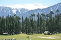 Pine forests occur in Swat at elevations over 1,500 m (5,000 ft)
 The northernmost region of Swat – a region known as Kohistan – has high alpine valley at the base of tall mountains
 Jarogo Waterfall, in middle Swat
 Alpine lakes, such as Mahodand Lake are found in the mountains of Swat Kohistan.
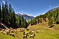 Alpine meadows in Utror


.jpg)
Notable people
- Wadud of Swat (Miangul Abdul Wadud)
- Jahan Zeb of Swat (Miangul Jahan Zeb)
- Miangul Aurangzeb
- Miangul Adnan Aurangzeb
- Mubarika Yusufzai
- Wāli of Swat
- Zebunisa Jilani
- Mahmood Khan
- Malala Yousafzai
- Ziauddin Yousafzai
- Muhib Ullah Khan
- Anwar Ali
- Nazia Iqbal
- Ghazala Javed
- Afzal Khan Lala
- Haider Ali Khan
- Jamila Ahmad
- Rahim Khan
- Nasirul Mulk
- Badar Munir
- Murad Saeed
- Shaheen Sardar Ali
- Rahim Shah
- Sherin Zada
Remove ads
References
Notes and Bibliography
External links
Wikiwand - on
Seamless Wikipedia browsing. On steroids.
Remove ads