Top Qs
Timeline
Chat
Perspective
Aalter
Municipality in Flemish Community, Belgium From Wikipedia, the free encyclopedia

Remove ads
Aalter (Dutch pronunciation: [ˈaːltər] ⓘ) is a municipality located between Bruges and Ghent in the Belgian province of East Flanders. The municipality comprises the towns of Aalter, Bellem, Lotenhulle, Poeke, Knesselare and Ursel. It is bordered on the north by Maldegem, on the east by Zomergem and Nevele, on the south by Deinze, and on the west by the province of West Flanders. The mayor is Pieter De Crem.[2]


Effective 1 January 2019, the municipality of Knesselare was merged into Aalter.[3] Aalter was home to 29,242 people in 2021.[4]
Remove ads
History
Aalter is located on the border of the Meetjesland with the forest of Flanders. The area was inhabited since prehistory. Artefacts have been recovered from 3,000 to 2,000 BC. The village was first mentioned in 974 as "Villa Haleftra". The etymology is unclear. The current name started to emerge around 1700. Aalter was home to several small heerlijkheden (landed estates), some of which had motte-and-bailey castles.[5][6]
Between 1613 and 1623, the Ghent-Bruges Canal was dug, and several fortifications were built by Spanish against the Dutch. In 1838, a railway station opened and Aalter started to develop into a town which nowadays has many commuters.[5][6]
Remove ads
Gallery
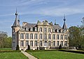

 Mariahove castle in Bellem
 Bandstand in the square

.JPG)
.jpg)

See also
References
External links
Wikiwand - on
Seamless Wikipedia browsing. On steroids.
Remove ads