Top Qs
Timeline
Chat
Perspective
Abraham Mountain
Mountain in Alberta, Canada From Wikipedia, the free encyclopedia

Remove ads
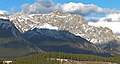
Abraham Mountain is a 2,820-metre (9,250-foot) mountain summit located in the North Saskatchewan River valley of the Canadian Rockies of Alberta, Canada. Its nearest higher peak is Allstones Peak, 2.0 km (1.2 mi) to the west.[1] Abraham Mountain can be seen from David Thompson Highway and Abraham Lake. Precipitation runoff from Abraham Mountain drains east into Abraham Lake.


Remove ads
History
Like the lake, the mountain was named for Silas Abraham (1871–1961), a Stoney Indian inhabitant of the Kootenay Plains and Saskatchewan River valley, who was employed by Mary Schäffer as her guide during her 1906 and 1907 explorations.[2] He also guided Martin Nordegg.[3]
Geology
Abraham Mountain is composed of sedimentary rock laid down from the Precambrian to Jurassic periods that was pushed east and over the top of younger rock during the Laramide orogeny.[4]
Climate
Based on the Köppen climate classification, Abraham Mountain is located in a subarctic climate zone with cold, snowy winters, and mild summers.[5] Temperatures can drop below −20 °C with wind chill factors below −30 °C.
Gallery
 Abraham Mountain seen from mouth of Cline River
 Allstones Peak (left) and Abraham Mountain (right)


See also
References
Wikiwand - on
Seamless Wikipedia browsing. On steroids.
Remove ads