Top Qs
Timeline
Chat
Perspective
Ak-Suu District
District in Issyk-Kul, Kyrgyzstan From Wikipedia, the free encyclopedia
Remove ads
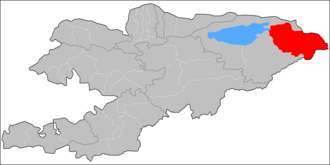
Ak-Suu (Kyrgyz: Ак-Суу району) is a district of Isxsyk-Kul Region in eastern Kyrgyzstan. The administrative center lies at the village Teploklyuchenka.[2] Its area is 9,917 square kilometres (3,829 sq mi),[3] and its resident population was 69,439 in 2021.[1]
Remove ads
Geography
Located in Kyrgyzstan's eastern corner, the district borders in the north with the Almaty Region of Kazakhstan, and in the east, with the Aksu Prefecture of China's Xinjiang Uyghur Autonomous Region. Two of Kyrgyzstan's highest mountains, Jengish Chokusu (Victory Peak, or Pobeda Peak in Russian) and Khan Tengri, are located on these borders. Some 93% of the district is occupied by mountains and 7% - by valleys [4]
Remove ads
Climate
The average temperature in January is -8 °C in valleys and -26 °C - in mountains. In July, the average monthly temperature varies from +14 °C in valleys and 9 °C - in mountains. The minimum temperature drops to 40 °C below zero. The average high temperatures are from +30 °C in valleys and +15 °C - in mountains. The total precipitation is from 300 to 400 mm in valleys and from 500 to 600 mm - in mountains. The snow accumulation reaches 40 cm in valleys. The maximum expected wind speed (once in 20-year period) is 34 m/s.[4]
Remove ads
Tourism
The Ak-Suu district is an important hub for Kyrgyzstan's adventure tourism industry centred on Karakol, most notably trekking to lake Ala-Köl and the newly-established Ak-Suu Traverse, a multi-day trek which typically takes between seven and nine days to complete.[5]
Demographics
The district population, as of 2021, was 69,439.[1] The population density was 7.0 people per square kilometer.
Ethnic composition
According to the 2009 Census, the ethnic composition (de jure population) of the Ak-Suu District was:[3]
Remove ads
Populated places
Summarize
Perspective

In total, Ak-Suu District includes 48 settlements in 14 rural communities (ayyl aymagy). Each rural community can consist of one or several villages. The rural communities and settlements in the Ak-Suu District are:[2][6]
- Ak-Bulung (seat: Ak-Bulung; incl. Ak-Bulak, Toktogul and Türgön)
- Ak-Chiy (seat: Ak-Chiy; incl. Kachybek, Kök-Jayyk, Kyzyl-Jar and Sovetskoye)
- Börü-Bash (seat: Börü-Bash; incl. Cherik)
- Boz-Uchuk (seat: Novovoznesenovka; incl. Boz-Uchuk and Ichke-Jergez)
- Chelpek (seat: Chelpek; incl. Burma-Suu and Tash-Kyya)
- Engilchek (seat: Engilchek, incl. Keng-Suu, Koyluu, Kurgak, May-Saz, Tash-Koroo and Echkili-Tash)
- Jyrgalang (seat: Jyrgalang)
- Kara-Jal (seat: Tegizchil; incl. Jangy-Aryk, Kara-Jal and Boz-Bulung)
- Karakol (seat: Karakol; incl. Cholpon)
- Kerege-Tash (seat: Sary-Kamysh; incl. Kerege-Tash, Kayyrma-Aryk, Novokonstantinovka and Pioner)
- Oktyabr (seat: Oktyabrskoye; incl. Jol-Kolot, Otuz-Uul and Üch-Kaynar)
- Otradnoye (seat: Otradnoye; incl. Orlinoye and Shapak)
- Tepke (seat: Tepke; incl. Jyldyz and Kurbu)
- Teploklyuchenka (seat: Teploklyuchenka; incl. Lesnoye)

Ak-Bulak
Toktogul
Türgön
Börü-Bash
Cherik
Tegizchil→
Jangy-Aryk
Kara-Jal
Boz-Bulung
Karakol
↑
Sary-
Kamysh
Sary-
Kamysh
←Kayyrma-Aryk
Kerege-
Tash
Tash
Novo-konstantinovka
←Pioner
Oktyabrskoye
Jol-Kolot
Üch-Kaynar
Otradnoye
Orlinoye
Shapak
Ak-Chiy
Kachybek
Kök-Jayyk
Kyzyl-Jar
Sovetskoye
Jyldyz
Lesnoye
↑
Chelpek
Chelpek
Burma-
Suu
Suu
←Tash-Kyya
Keng-Suu
Koyluu
Kurgak
May-Saz
Tash-Koroo
Echkili-Tash
Settlements of the Ak-Suu District
Remove ads
References
Wikiwand - on
Seamless Wikipedia browsing. On steroids.
Remove ads

