Top Qs
Timeline
Chat
Perspective
Alberta Highway 40
Highway in Alberta, Canada From Wikipedia, the free encyclopedia

Remove ads
Highway 40 is a south–north highway in western Alberta, Canada.[2] It is also named Bighorn Highway and Kananaskis Trail in Kananaskis Country. Its segmented sections extend from Coleman in the Municipality of Crowsnest Pass northward to the City of Grande Prairie and is currently divided into four sections.[3]

.svg)
Remove ads
Route description
Summarize
Perspective
The southernmost section is gravel; it runs for 3.9 km (2.4 mi) through the Municipality of Crowsnest Pass, where it then becomes the Forestry Trunk Road to Highway 541, which has a combined length of 102 km (63 mi).
The second section of Highway 40 is Kananaskis Trail, which is paved and runs through Kananaskis Country for 104 km (65 mi) from Highway 541, over Highwood Pass, and through Peter Lougheed Provincial Park and Spray Valley Provincial Park. The highway passes Kananaskis Village before terminating at the Trans-Canada Highway (Highway 1).[4]
The third section is gravel and is part of the Forestry Trunk Road, which runs 46 km (29 mi) from Highway 1A to Highway 579. The highway continues as the Forestry Trunk Road and Highway 734 for approximately 293 km (182 mi), through the Rocky Mountains Forest Reserve. The intention is that one day the entire road will be a continuous paved highway. In the past, other gravel sections were named Highway 940; the 900 series in Alberta is used for temporary names. There is no signed connection between the Kananaskis Trail section and the Forestry Trunk Road section; however, it is connected by using Highway 1, Highway 1X, and Highway 1A between Seebe and Ghost Lake.
The fourth section is 434 km (270 mi) and runs from the Lovett River in Yellowhead County to the City of Grande Prairie. The 61 km (38 mi) section south of Cadomin is gravel while the remainder is paved. The highway shares 2 km (1.2 mi) concurrency with the Yellowhead Highway (Highway 16), before continuing north and passing through the Hamlet of Grande Cache en route to Grande Prairie.[5]
Remove ads
Old Highway 40
A section of what is today Alberta Highway 501 on the south edge of the province, running between Cardston and Whiskey Gap was originally designated as Highway 40 prior to the 1970s. A further section of roadway marked Old Highway 40 runs south of Highway 501 from a junction south of Taylorville, and runs to the U.S. border. The only location of note along this roadway is a stone monument to Mormon settlers.
Remove ads
Major intersections
Summarize
Perspective
Starting from the south end of Highway 40:
Remove ads
Gallery
 Highway 40 crossing Wapiti River south of Grande Prairie
 Highway 40 in Grande Cache
 Bighorn Highway, westbound, east of Grande Cache
 Highway 734 through the Foothills, southbound, north of Nordegg
 Kananaskis Trail, southbound through the Canadian Rockies in Kananaskis Country
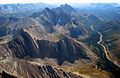 Kananaskis Trail at Highwood Pass


References
Wikiwand - on
Seamless Wikipedia browsing. On steroids.
Remove ads