Top Qs
Timeline
Chat
Perspective
Amfikleia
Municipal unit in Greece From Wikipedia, the free encyclopedia

Remove ads
Amfikleia (Greek: Αμφίκλεια, before 1915: Δαδί - Dadi[2]) is a town and a former municipality in Phthiotis, Greece. Since the 2011 local government reform it is part of the municipality Amfikleia-Elateia, of which it is a municipal unit.[3] The municipal unit has an area of 229.366 km2, the community 108.124 km2.[4] At the 2021 census, the population of the municipal unit was 2,996 and of the community 2,157.[1] The town is situated at the northern foot of Mount Parnassus, in the valley of the river Cephissus.[5] It is 11 km northwest of Kato Tithorea and 31 km southeast of Lamia. Greek National Road 3 (Thebes - Lamia) passes through the town. The town is served by a railway station with connections on the Athens–Thessaloniki railway.

Remove ads
Subdivisions
The municipal unit Amfikleia consists of the following communities:
- Amfikleia
- Bralos
- Drymaia
- Palaiochori
- Tithroni
- Xylikoi
History
Amfikleia was named after the ancient town Amphicleia (Ancient Greek: Ἀμφίκλεια). Amphicleia was also named Amphicaea (Ἀμφίκαια) and Ophiteia (Ὀφιτεία). It was situated in the north of ancient Phocis.[6] The Persians under Xerxes destroyed the city in 480 BC during the second Persian invasion of Greece.[7] It was rebuilt afterwards, and at the time of Pausanias (2nd century AD), it was known for the worship of Dionysus.[6][8]
During the Middle Ages, a tower was built on the site of the acropolis. Today the site is occupied by the cemetery.[5]
Dadi, which was founded near the site of ancient Amphicleia, became a vibrant town; in early 19th century, William Leake reported 500 families living in the town.[9] Dadi was renamed to Amfikleia in 1915.[2]
Remove ads
Notable people
- Athanasios Eftaxias (1849–1931), politician
Gallery
 The church of Holy Jerusalem above Amfikleia
 Memorial to the 11 inhabitants executed by the Germans in 1943 as reprisals for a sabotage attack on Amfikleia railway station
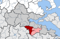 Position of Amfiklia municipal unit in Amfiklia-Elatia Municipality, Fthiotida Regional Unit Greece


References
External links
Wikiwand - on
Seamless Wikipedia browsing. On steroids.
Remove ads