Top Qs
Timeline
Chat
Perspective
Ancient and Primeval Beech Forests of the Carpathians and Other Regions of Europe
UNESCO world heritage site From Wikipedia, the free encyclopedia

Remove ads
Ancient and Primeval Beech Forests of the Carpathians and Other Regions of Europe is a transnational serial nature UNESCO World Heritage Site, encompassing 93 component parts (forests of European beech, Fagus sylvatica) in 18 European countries.[1][2][3] Together, the sites protect the largest and least disturbed forests dominated by the beech tree. In many of these stands, especially those in the Carpathians, beech forests have persisted without interruption or interference since the last ice age. These sites document the undisturbed postglacial repopulation of the species.[1]
_valley_42.jpg)
Remove ads
Carpathian region
Summarize
Perspective
This section needs to be updated. The reason given is: This part appears to be written before 2017. (August 2021) |
The Primeval Beech Forests of the Carpathians include ten separate massifs located along the 185 km (115 mi) long axis from the Rakhiv mountains and Chornohora ridge in Ukraine over the Poloniny Ridge (Slovakia) to the Vihorlat Mountains in Slovakia. The Ancient Beech Forests of Germany include five locations, cover 4,391 hectares and were added in 2011.
The Carpathian site covers a total area of 77,971.6 ha (192,672 acres), out of which only 29,278.9 ha (72,350 acres) are part of the actual preserved area, while the rest is considered a "buffer zone". Primeval Beech Forests of the Carpathians cover areas of Zakarpattia and Prešov Regions. Over 70% of the site is located in Ukraine. The area includes two national parks, and some habitat controlled areas, mostly in Slovakia. Both national parks, along with a neighboring area in Poland, compose a separate biosphere reserve, the East Carpathian Biosphere Reserve. Besides Havešová, Rožok, and Stužica (all of them located in Bukovské vrchy), there is a fourth component situated in Slovakia, named Kyjovský prales of Vihorlat. Ukrainian locations include Chornohora, Kuziy-Trybushany, Maramarosh,[n 1] Stuzhytsia–Uzhok, Svydovets, and Uholka–Shyrikyi Luh. Only a few of the ten components are accessible to visitors. Stužica is the only one of three locations in Bukovské vrchy (Slovakia) with available hiking trails. In 2017, UNESCO extended the site, adding forests in Albania, Austria, Belgium, Bulgaria, Croatia, Italy, Romania, Slovenia, and Spain.[4] In 2021 UNESCO extended the site again adding forests in Bosnia and Herzegovina, Czechia, France, Italy, North Macedonia, Poland, Slovakia and Switzerland.[5] Then in 2023 further minor extensions were made, including an expansion to the Dürrenstein-Lassingtal site in Austria, and the addition of a forest at Paklenica National Park in Croatia, including former Paklenica National Park-Suva draga-Klimenta and -Oglavinovac-Javornik.[6]
Remove ads
List of component parts
Summarize
Perspective


Poloniny
Vihorlat
Chornohora
Kuziy-Trybushany
Maramarosh
Stuzhytsia – Uzhok
Svydovets
Uholka – Shyrokyi Luh
Grumsin
Hainich
Jasmund
Kellerwald
Serrahn
Lumi i gashit
Rrajca
Dürrenstein-Lassingtal
Kalkalpen
Sonian Forest
Central Balkan
Hajdučki i Rožanski Kukovi
Paklenica
Abruzzo, Lazio & Molise
Pollino
Foresta Umbra
Monte Cimino
Monte Raschio
Sasso Fratino
Cheile Nerei-Beușnița
Codrul Secular Șinca
Codrul Secular Slătioara
Cozia
Domogled - Valea Cernei-
Groșii Țibleșului
Izvoarele Nerei
Strâmbu Băiuț
Krokar
Snežnik-Ždrocle
Hayedos de Ayllon
Hayedos de Navarra
Hayedos de Picos de Europa
Gorgany
Roztochchya
Satanіvska Dacha
Synevyr
Zacharovanyi Krai
Prašuma Janj
Jizera Mountains
Chapitre
Grand Ventron
Massane
Valle Infernale
Dlaboka Reka
Bieszczady
Forêt de la Bettlachstock
Valli di Lodano, Busai & Soladino
Location of Ancient and Primeval Beech Forests (component clusters) in Europe
The component parts included in the site as of December 2023 are:[1][7][8][9][10][11][12][13][14][2][3][15]
* Only boundary modification.
Udava (Bukovské Vrchy, Slovakia) was created by modifying the boundary of Stužica before. Falascone (Italy) in turn was named previously Umbra Forest (Foresta Umbra).[13][14][2]
This is a transnational serial nature UNESCO World Heritage Site, encompassing 94 component parts (forests) in 18 European countries.[1][2] The total area of component parts is 99,947.81 ha (246,976.4 acres), including buffer zones 396,223.61 ha (979,089.9 acres).[1] The largest total area of component parts is in Ukraine and Romania – 53% total (41% including buffer zones).
Remove ads
Forms of protection
Summarize
Perspective
Component parts of this property overlap more or less with various protected areas like national parks, nature reserves, Natura 2000 network.[16][17][18][11][13][19][20]
Abbreviations:
C – count of component parts in a given cluster
N – overlapping with Natura 2000 areas
Remove ads
Tentative list
This forest is placed on the World Heritage Tentative list as a proposal for the expansion of the Ancient and Primeval Beech Forests of the Carpathians and Other Regions of Europe site:
Montenegro[21]
- Virgin Forest Reserve in NP Biogradska Gora
Serbia[12]
Gallery
 Forest in Stuzica
 Havešová
 Stužica
 Freshwater stream in Stužica
 Stužica
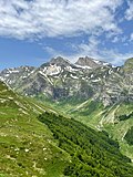 Dlaboka Reka


Notes
- "Maramorosh" changed to "Maramarosh".
- Geographic coordinates corrected from "N49 4 14 E22 3 1" to N49°4’58’’ E22°35’45’’
- "Uholka-Shyrikyi Luh" corrected to "Uholka-Shyrokyi Luh".
- "Strimbu Băiuț" changed to "Strâmbu Băiuț".
- "Gorna Solinka" corrected to "Górna Solinka".
- "Polonina Wetlinska" corrected to "Połonina Wetlińska".
- "Roztochya" corrected to "Roztochchia".
- "Peesh skali" corrected to "Peeshti skali".
- Latitude corrected from "N41 143" to N41°14’43’’
- "Cuesta Fria" changed to "Cuesta Fría".
Remove ads
References
External links
Wikiwand - on
Seamless Wikipedia browsing. On steroids.
Remove ads